Property Record
811 Valley Rd, Mansfield, PA 16933


NEARBY LISTINGS FOR SALE OR LEASE
-
-
View all Mansfield listings for sale on LoopNet.com
Property Detail
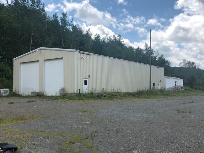
811 Valley Rd
Commercialnec
Scott L Hhouse
X
Tioga
42117C0386D
Pennsylvania
2025
7.46 AC
2025
Pennsylvania Central Area
950600
Other Market Areas
4,504 SF
29-05.00-022
DEMOGRAPHICS near 811 Valley Rd
1 Mile
3 Mile
5 Mile
2024 Total Population
178
4,966
6,667
2029 Population
176
5,002
6,663
Pop Growth 2024-2029
(1.12%)
+ 0.72%
(0.06%)
Average Age
46
38
39
2024 Total Households
80
1,786
2,502
HH Growth 2024-2029
(1.25%)
+ 0.22%
(0.48%)
Median Household Inc
$53,889
$46,566
$50,915
Avg Household Size
2.20
2.20
2.20
2024 Avg HH Vehicles
2.00
2.00
2.00
Median Home Value
$216,667
$175,984
$186,614
Median Year Built
1980
1973
1974
Nearby Places
Map Layers
Map Styles
 Street
 Aerial
- Restaurants
- Banks
- Shops
- Fitness
- Groceries
PUBLIC TRANSPORTATION
AIRPORT
Elmira/Corning Regional
DRIVE
WALK
Distance
Elmira/Corning Regional
55 min
42.3 mi
SALE & LEASE HISTORY
LISTING DATE
SALE/LEASE

Jun 14, 2018
For Lease
Jul 09, 2021
For Sale
Nearby Properties
Address
Land Use
TOTAL SIZE
Lot Size
Zoning
Address
Land Use
TOTAL SIZE
Lot Size
Zoning
581,537 SF
175 AC
Address
Land Use
TOTAL SIZE
Lot Size
Zoning
407,773 SF
Address
Land Use
TOTAL SIZE
Lot Size
Zoning
173,689 SF
30.83 AC
Address
Land Use
TOTAL SIZE
Lot Size
Zoning
155,591 SF
12.83 AC
Address
Land Use
TOTAL SIZE
Lot Size
Zoning
111,033 SF
26.16 AC
Address
Land Use
TOTAL SIZE
Lot Size
Zoning
74,850 SF
14.29 AC
Address
Land Use
TOTAL SIZE
Lot Size
Zoning
62,749 SF
4.13 AC
Address
Land Use
TOTAL SIZE
Lot Size
Zoning
98,611 SF
3.68 AC
Address
Land Use
TOTAL SIZE
Lot Size
Zoning
38,540 SF
4.69 AC
Address
Land Use
TOTAL SIZE
Lot Size
Zoning
42,272 SF
4.57 AC
Address
Land Use
TOTAL SIZE
Lot Size
Zoning
58,160 SF
9.51 AC
Address
Land Use
TOTAL SIZE
Lot Size
Zoning
59,616 SF
3.74 AC
Address
Land Use
TOTAL SIZE
Lot Size
Zoning
19,242 SF
0.38 AC
Address
Land Use
TOTAL SIZE
Lot Size
Zoning
27,162 SF
6.41 AC
Address
Land Use
TOTAL SIZE
Lot Size
Zoning
19,568 SF
4.39 AC
Address
Land Use
TOTAL SIZE
Lot Size
Zoning
16,091 SF
2.52 AC
Address
Land Use
TOTAL SIZE
Lot Size
Zoning
36,480 SF
1.43 AC
Address
Land Use
TOTAL SIZE
Lot Size
Zoning
47,280 SF
1.49 AC
Address
Land Use
TOTAL SIZE
Lot Size
Zoning
49,172 SF
4.47 AC
Address
Land Use
TOTAL SIZE
Lot Size
Zoning
14,591 SF
100.04 AC
Address
Land Use
TOTAL SIZE
Lot Size
Zoning
14,470 SF
0.20 AC
Address
Land Use
TOTAL SIZE
Lot Size
Zoning
32,352 SF
1.15 AC
Address
Land Use
TOTAL SIZE
Lot Size
Zoning
902.76 AC
Address
Land Use
TOTAL SIZE
Lot Size
Zoning
60,012 SF
7.20 AC
Address
Land Use
TOTAL SIZE
Lot Size
Zoning
23,051 SF
3.63 AC
Address
Land Use
TOTAL SIZE
Lot Size
Zoning
21,585 SF
9.51 AC
Address
Land Use
TOTAL SIZE
Lot Size
Zoning
8,498 SF
1.55 AC
Address
Land Use
TOTAL SIZE
Lot Size
Zoning
20,760 SF
1 AC
Address
Land Use
TOTAL SIZE
Lot Size
Zoning
11,776 SF
1.41 AC
Address
Land Use
TOTAL SIZE
Lot Size
Zoning
11,756 SF
0.23 AC
The World's #1 Commercial Real Estate Marketplace
Connect with us
© 2025 CoStar Group
The information above has been obtained from sources believed reliable. While we do not doubt its accuracy we have not verified it and make no guarantee, warranty or representation about it. It is your responsibility to independently confirm its accuracy and completeness. Any projections, opinions, assumptions, or estimates used are for example only and do not represent the current or future performance of the property. The value of this transaction to you depends on tax and other factors which should be evaluated by your tax, financial, and legal advisors. You and your advisors should conduct a careful, independent investigation of the property to determine to your satisfaction the suitability of the property for your needs.