Property Record
8110 W Purdue Pl, Sioux Falls, SD 57106
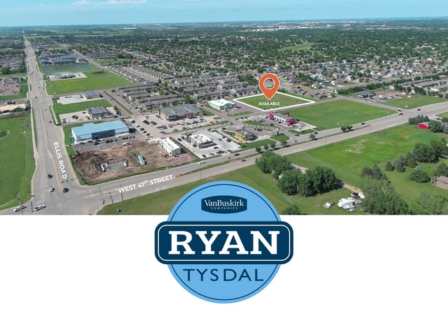

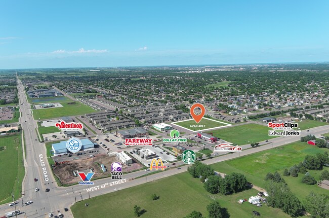
Current Lease Availabilities
Property Detail
8110 W Purdue Pl
Other Market Areas
Elrods Addition
Sioux Falls, SD-MN
LOT 7 BLOCK 7 OF ELRODS ADDITION AN ADDITION TO THE CITY OF SIOUX FALLS
96080
Minnehaha
Commercialacreage
South Dakota
2024
7
2024
2.24 AC
001111
Sioux Falls
NEARBY LISTINGS FOR SALE OR LEASE
DEMOGRAPHICS near 8110 W Purdue Pl
1 mile
3 mile
5 mile
2024 Total Population
12,315
56,239
116,716
2029 Population
14,201
66,814
142,293
Pop Growth 2024-2029
+ 15.31%
+ 18.80%
+ 21.91%
Average Age
35
37
37
2024 Total Households
4,699
22,683
47,703
HH Growth 2024-2029
+ 16.41%
+ 19.69%
+ 22.43%
Median Household Inc
$92,230
$77,418
$73,011
Avg Household Size
2.60
2.40
2.40
2024 Avg HH Vehicles
2.00
2.00
2.00
Median Home Value
$351,368
$290,049
$291,794
Median Year Built
2008
2000
1998
Nearby Places
Map Layers
Map Styles
 Street
 Aerial
Transit
 Traffic
 Biking
Places
Listings with unknown addresses are not visible on the map
- Restaurants
- Banks
- Shops
- Fitness
- Groceries
PUBLIC TRANSPORTATION
AIRPORT
Joe Foss Field
Drive
Walk
Distance
Joe Foss Field
19 min
10.6 mi
Nearby Properties
Address
Land Use
TOTAL SIZE
Lot Size
Zoning
Address
Land Use
TOTAL SIZE
Lot Size
Zoning
639,393 SF
53.46 AC
FP;FP
Address
Land Use
TOTAL SIZE
Lot Size
Zoning
8.80 AC
MUNICIPALI
Address
Land Use
TOTAL SIZE
Lot Size
Zoning
32,169 SF
9.91 AC
Address
Land Use
TOTAL SIZE
Lot Size
Zoning
55,998 SF
5.42 AC
FP;FP
Address
Land Use
TOTAL SIZE
Lot Size
Zoning
8.51 AC
MUNICIPALI
Address
Land Use
TOTAL SIZE
Lot Size
Zoning
15.40 AC
MUNICIPALI
Address
Land Use
TOTAL SIZE
Lot Size
Zoning
15.89 AC
Address
Land Use
TOTAL SIZE
Lot Size
Zoning
8.57 AC
MUNICIPALI
Address
Land Use
TOTAL SIZE
Lot Size
Zoning
13,806 SF
10.99 AC
Address
Land Use
TOTAL SIZE
Lot Size
Zoning
100,053 SF
8.50 AC
FP;FP
Address
Land Use
TOTAL SIZE
Lot Size
Zoning
9.56 AC
MUNICIPALI
Address
Land Use
TOTAL SIZE
Lot Size
Zoning
16.45 AC
MUNICIPALI
Address
Land Use
TOTAL SIZE
Lot Size
Zoning
7.07 AC
MUNICIPALI
Address
Land Use
TOTAL SIZE
Lot Size
Zoning
1.66 AC
FP;FP
Address
Land Use
TOTAL SIZE
Lot Size
Zoning
23,832 SF
216 AC
Address
Land Use
TOTAL SIZE
Lot Size
Zoning
Address
Land Use
TOTAL SIZE
Lot Size
Zoning
26,601 SF
5.31 AC
Address
Land Use
TOTAL SIZE
Lot Size
Zoning
72,601 SF
15.33 AC
Address
Land Use
TOTAL SIZE
Lot Size
Zoning
21,060 SF
6.70 AC
FP;FP
Address
Land Use
TOTAL SIZE
Lot Size
Zoning
9.27 AC
MUNICIPALI
Address
Land Use
TOTAL SIZE
Lot Size
Zoning
8,768 SF
5.48 AC
Address
Land Use
TOTAL SIZE
Lot Size
Zoning
5,649 SF
9.13 AC
Address
Land Use
TOTAL SIZE
Lot Size
Zoning
9.16 AC
MUNICIPALI
Address
Land Use
TOTAL SIZE
Lot Size
Zoning
185,662 SF
18.09 AC
Address
Land Use
TOTAL SIZE
Lot Size
Zoning
23,606 SF
6.03 AC
Address
Land Use
TOTAL SIZE
Lot Size
Zoning
5.27 AC
MUNICIPALI
Address
Land Use
TOTAL SIZE
Lot Size
Zoning
72,820 SF
12.43 AC
Address
Land Use
TOTAL SIZE
Lot Size
Zoning
214,855 SF
14.65 AC
FP;FP
Address
Land Use
TOTAL SIZE
Lot Size
Zoning
1,796 SF
7.57 AC
Address
Land Use
TOTAL SIZE
Lot Size
Zoning
18,451 SF
6.12 AC
The World's #1 Commercial Real Estate Marketplace
Connect with us
© 2026 CoStar Group
The information above has been obtained from sources believed reliable. While we do not doubt its accuracy we have not verified it and make no guarantee, warranty or representation about it. It is your responsibility to independently confirm its accuracy and completeness. Any projections, opinions, assumptions, or estimates used are for example only and do not represent the current or future performance of the property. The value of this transaction to you depends on tax and other factors which should be evaluated by your tax, financial, and legal advisors. You and your advisors should conduct a careful, independent investigation of the property to determine to your satisfaction the suitability of the property for your needs.