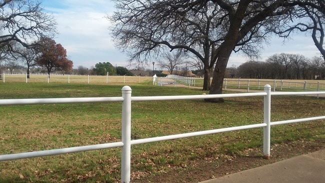
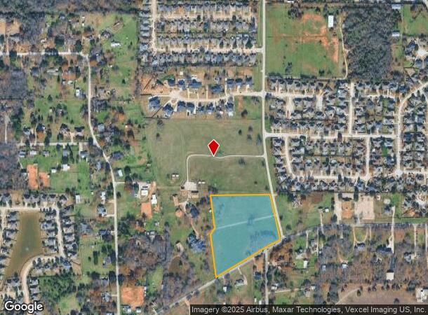
Property Record
8110 Russell Curry Rd, Arlington, TX 76001

NEARBY LISTINGS FOR SALE OR LEASE
Property Detail
8110 Russell Curry Rd
Dallas-Fort Worth-Arlington, TX
Curry, William H Survey
06249779
CURRY, WILLIAM H SURVEY ABSTRACT 277 TRACT 1B02
Timberlandforesttreesagricultural
Tarrant
X
Texas
48251C0100J
9.06 AC
2024
Arlington/Mansfield
2025
Dallas/Ft Worth
111408
DEMOGRAPHICS near 8110 Russell Curry Rd
1 Mile
3 Mile
5 Mile
2024 Total Population
3,218
57,215
186,795
2029 Population
3,440
60,406
196,712
Pop Growth 2024-2029
+ 6.90%
+ 5.58%
+ 5.31%
Average Age
40
39
38
2024 Total Households
1,063
19,478
63,619
HH Growth 2024-2029
+ 6.96%
+ 5.65%
+ 5.36%
Median Household Inc
$112,019
$96,527
$89,352
Avg Household Size
3.00
2.90
2.90
2024 Avg HH Vehicles
2.00
2.00
2.00
Median Home Value
$353,533
$319,858
$284,337
Median Year Built
2004
1998
1993
Nearby Places
Map Layers
Map Styles
 Street
 Aerial
- Restaurants
- Banks
- Shops
- Fitness
- Groceries
PUBLIC TRANSPORTATION
AIRPORT
Dallas-Fort Worth International
DRIVE
WALK
Distance
Dallas-Fort Worth International
42 min
30.2 mi
Dallas Love Field
DRIVE
WALK
Distance
Dallas Love Field
50 min
38.8 mi
Freight Ports
Port of Shreveport
DRIVE
WALK
Distance
Port of Shreveport
242 min
224.5 mi
SALE & LEASE HISTORY
LISTING DATE
SALE/LEASE

Mar 27, 2017
For Sale
Nearby Properties
Address
Land Use
TOTAL SIZE
Lot Size
Zoning
Address
Land Use
TOTAL SIZE
Lot Size
Zoning
348,951 SF
18.66 AC
Address
Land Use
TOTAL SIZE
Lot Size
Zoning
160,000 SF
26.90 AC
Address
Land Use
TOTAL SIZE
Lot Size
Zoning
413,000 SF
19.16 AC
Address
Land Use
TOTAL SIZE
Lot Size
Zoning
298,988 SF
7.16 AC
Address
Land Use
TOTAL SIZE
Lot Size
Zoning
249,922 SF
17.26 AC
Address
Land Use
TOTAL SIZE
Lot Size
Zoning
170,082 SF
36.49 AC
Address
Land Use
TOTAL SIZE
Lot Size
Zoning
724,286 SF
48.41 AC
Address
Land Use
TOTAL SIZE
Lot Size
Zoning
208,630 SF
8.62 AC
Address
Land Use
TOTAL SIZE
Lot Size
Zoning
214,444 SF
17.45 AC
Address
Land Use
TOTAL SIZE
Lot Size
Zoning
231,551 SF
25.69 AC
Address
Land Use
TOTAL SIZE
Lot Size
Zoning
171,820 SF
59.63 AC
Address
Land Use
TOTAL SIZE
Lot Size
Zoning
234,580 SF
65.82 AC
Address
Land Use
TOTAL SIZE
Lot Size
Zoning
167,643 SF
8.99 AC
Address
Land Use
TOTAL SIZE
Lot Size
Zoning
169,347 SF
13.92 AC
Address
Land Use
TOTAL SIZE
Lot Size
Zoning
229,168 SF
6.13 AC
Address
Land Use
TOTAL SIZE
Lot Size
Zoning
399,496 SF
23.29 AC
Address
Land Use
TOTAL SIZE
Lot Size
Zoning
149,494 SF
3.73 AC
Address
Land Use
TOTAL SIZE
Lot Size
Zoning
79,070 SF
11.98 AC
Address
Land Use
TOTAL SIZE
Lot Size
Zoning
217,786 SF
39.04 AC
Address
Land Use
TOTAL SIZE
Lot Size
Zoning
268,603 SF
12.45 AC
Address
Land Use
TOTAL SIZE
Lot Size
Zoning
238,119 SF
7.52 AC
Address
Land Use
TOTAL SIZE
Lot Size
Zoning
119,741 SF
45 AC
Address
Land Use
TOTAL SIZE
Lot Size
Zoning
275,337 SF
14 AC
Address
Land Use
TOTAL SIZE
Lot Size
Zoning
158,103 SF
13.27 AC
Address
Land Use
TOTAL SIZE
Lot Size
Zoning
86,342 SF
12.15 AC
Address
Land Use
TOTAL SIZE
Lot Size
Zoning
3,600 SF
43.24 AC
Address
Land Use
TOTAL SIZE
Lot Size
Zoning
249,888 SF
11.57 AC
Address
Land Use
TOTAL SIZE
Lot Size
Zoning
206,568 SF
14.66 AC
Address
Land Use
TOTAL SIZE
Lot Size
Zoning
355,228 SF
37.53 AC
Address
Land Use
TOTAL SIZE
Lot Size
Zoning
85,786 SF
9.43 AC
The World's #1 Commercial Real Estate Marketplace
Connect with us
© 2025 CoStar Group
The information above has been obtained from sources believed reliable. While we do not doubt its accuracy we have not verified it and make no guarantee, warranty or representation about it. It is your responsibility to independently confirm its accuracy and completeness. Any projections, opinions, assumptions, or estimates used are for example only and do not represent the current or future performance of the property. The value of this transaction to you depends on tax and other factors which should be evaluated by your tax, financial, and legal advisors. You and your advisors should conduct a careful, independent investigation of the property to determine to your satisfaction the suitability of the property for your needs.