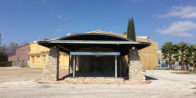
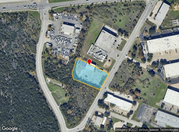
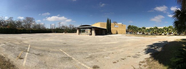
Property Record
8110 Springdale Rd, Austin, TX 78724

NEARBY LISTINGS FOR SALE OR LEASE
Property Detail
8110 Springdale Rd
Austin-Round Rock, TX
Springdale Commercial Ii
230789
LOT 1 SPRINGDALE COMMERCIAL II
Warehouse
Travis
A
Texas
48453C0460K
1
2024
1.96 AC
2025
East
002201
Austin
16,190 SF
DEMOGRAPHICS near 8110 Springdale Rd
1 Mile
3 Mile
5 Mile
2024 Total Population
5,211
90,644
269,395
2029 Population
5,615
98,819
294,408
Pop Growth 2024-2029
+ 7.75%
+ 9.02%
+ 9.28%
Average Age
36
35
36
2024 Total Households
1,988
33,056
109,318
HH Growth 2024-2029
+ 8.20%
+ 9.72%
+ 10.08%
Median Household Inc
$78,160
$55,502
$65,241
Avg Household Size
2.50
2.60
2.30
2024 Avg HH Vehicles
2.00
2.00
2.00
Median Home Value
$343,459
$338,400
$393,248
Median Year Built
1989
1986
1988
Nearby Places
Map Layers
Map Styles
 Street
 Aerial
- Restaurants
- Banks
- Shops
- Fitness
- Groceries
PUBLIC TRANSPORTATION
COMMUTER RAIL
DRIVE
WALK
Distance
17 min
9.4 mi
AIRPORT
Austin-Bergstrom International
DRIVE
WALK
Distance
Austin-Bergstrom International
25 min
14.0 mi
SALE & LEASE HISTORY
LISTING DATE
SALE/LEASE

Sep 24, 2016
For Lease
Sep 23, 2016
For Sale
Aug 28, 2019
For Sale
Apr 15, 2017
For Sale
Nearby Properties
Address
Land Use
TOTAL SIZE
Lot Size
Zoning
Address
Land Use
TOTAL SIZE
Lot Size
Zoning
372,075 SF
4.97 AC
Address
Land Use
TOTAL SIZE
Lot Size
Zoning
729,000 SF
16.16 AC
Address
Land Use
TOTAL SIZE
Lot Size
Zoning
367,756 SF
10.66 AC
Address
Land Use
TOTAL SIZE
Lot Size
Zoning
425,200 SF
2.49 AC
Address
Land Use
TOTAL SIZE
Lot Size
Zoning
126.15 AC
Address
Land Use
TOTAL SIZE
Lot Size
Zoning
274,943 SF
42.35 AC
Address
Land Use
TOTAL SIZE
Lot Size
Zoning
376,385 SF
26.47 AC
Address
Land Use
TOTAL SIZE
Lot Size
Zoning
306,658 SF
9.49 AC
Address
Land Use
TOTAL SIZE
Lot Size
Zoning
76,454 SF
199.64 AC
Address
Land Use
TOTAL SIZE
Lot Size
Zoning
115,640 SF
18 AC
Address
Land Use
TOTAL SIZE
Lot Size
Zoning
769,240 SF
71.87 AC
Address
Land Use
TOTAL SIZE
Lot Size
Zoning
320,797 SF
12.04 AC
Address
Land Use
TOTAL SIZE
Lot Size
Zoning
264,401 SF
10.48 AC
Address
Land Use
TOTAL SIZE
Lot Size
Zoning
252,450 SF
2.72 AC
Address
Land Use
TOTAL SIZE
Lot Size
Zoning
254,796 SF
11.29 AC
Address
Land Use
TOTAL SIZE
Lot Size
Zoning
277,987 SF
11.01 AC
Address
Land Use
TOTAL SIZE
Lot Size
Zoning
267,928 SF
2.50 AC
Address
Land Use
TOTAL SIZE
Lot Size
Zoning
92.83 AC
Address
Land Use
TOTAL SIZE
Lot Size
Zoning
7,268 SF
29.08 AC
Address
Land Use
TOTAL SIZE
Lot Size
Zoning
241,800 SF
13.27 AC
Address
Land Use
TOTAL SIZE
Lot Size
Zoning
399,650 SF
22.87 AC
Address
Land Use
TOTAL SIZE
Lot Size
Zoning
594,000 SF
55.12 AC
Address
Land Use
TOTAL SIZE
Lot Size
Zoning
228,331 SF
13.63 AC
Address
Land Use
TOTAL SIZE
Lot Size
Zoning
316,064 SF
18.98 AC
Address
Land Use
TOTAL SIZE
Lot Size
Zoning
336,658 SF
22.91 AC
Address
Land Use
TOTAL SIZE
Lot Size
Zoning
253,578 SF
21.12 AC
Address
Land Use
TOTAL SIZE
Lot Size
Zoning
206,250 SF
6 AC
Address
Land Use
TOTAL SIZE
Lot Size
Zoning
350,341 SF
30.34 AC
Address
Land Use
TOTAL SIZE
Lot Size
Zoning
168,450 SF
8.16 AC
Address
Land Use
TOTAL SIZE
Lot Size
Zoning
272,286 SF
27.02 AC
The World's #1 Commercial Real Estate Marketplace
Connect with us
© 2025 CoStar Group
The information above has been obtained from sources believed reliable. While we do not doubt its accuracy we have not verified it and make no guarantee, warranty or representation about it. It is your responsibility to independently confirm its accuracy and completeness. Any projections, opinions, assumptions, or estimates used are for example only and do not represent the current or future performance of the property. The value of this transaction to you depends on tax and other factors which should be evaluated by your tax, financial, and legal advisors. You and your advisors should conduct a careful, independent investigation of the property to determine to your satisfaction the suitability of the property for your needs.