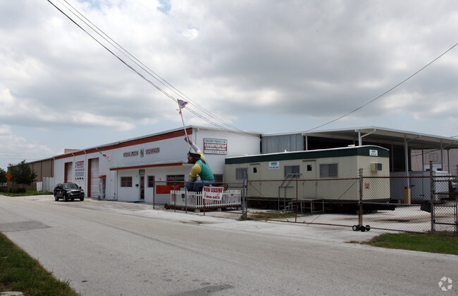
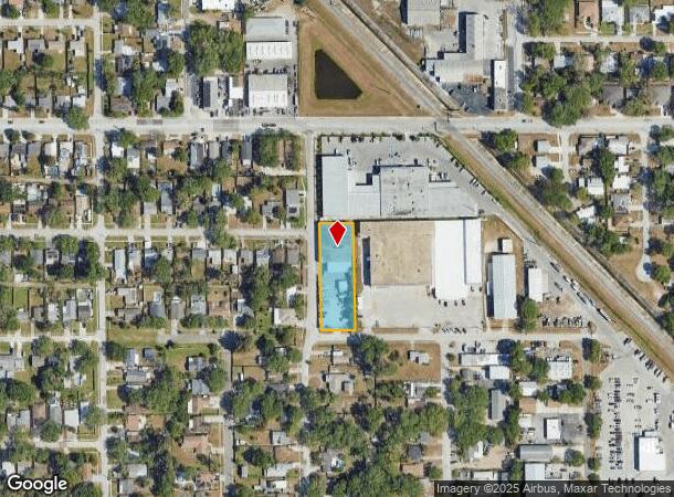
Property Record
8111 63Rd St N, Pinellas Park, FL 33781

NEARBY LISTINGS FOR SALE OR LEASE
Property Detail
8111 63Rd St N
Tampa-St. Petersburg-Clearwater, FL
Pinellas Park Industries
29-30-16-71168-000-0060
PINELLAS PARK INDUSTRIES LOT 6 & S 1/2 OF VAC PVT R/W ADJ ON N PER O.R. 13580/895
Lightindustrial
Pinellas
X
Florida
12103C0201J
6
2024
0.82 AC
2025
South Pinellas
024904
Tampa/St Petersburg
14,058 SF
DEMOGRAPHICS near 8111 63Rd St N
1 Mile
3 Mile
5 Mile
2024 Total Population
13,623
106,133
260,630
2029 Population
13,487
106,569
261,100
Pop Growth 2024-2029
(1.00%)
+ 0.41%
+ 0.18%
Average Age
41
45
45
2024 Total Households
5,257
46,086
116,946
HH Growth 2024-2029
(1.31%)
+ 0.36%
+ 0.08%
Median Household Inc
$60,376
$54,901
$57,659
Avg Household Size
2.40
2.20
2.10
2024 Avg HH Vehicles
2.00
2.00
2.00
Median Home Value
$254,832
$215,139
$223,262
Median Year Built
1975
1974
1973
Nearby Places
Map Layers
Map Styles
 Street
 Aerial
- Restaurants
- Banks
- Shops
- Fitness
- Groceries
PUBLIC TRANSPORTATION
AIRPORT
St Pete-Clearwater International
DRIVE
WALK
Distance
St Pete-Clearwater International
20 min
8.2 mi
Tampa International
DRIVE
WALK
Distance
Tampa International
31 min
19.3 mi
Freight Ports
Port Manatee
DRIVE
WALK
Distance
Port Manatee
46 min
32.7 mi
SALE & LEASE HISTORY
LISTING DATE
SALE/LEASE

Mar 30, 2018
For Sale
Aug 11, 2022
For Sale
Nearby Properties
Address
Land Use
TOTAL SIZE
Lot Size
Zoning
Address
Land Use
TOTAL SIZE
Lot Size
Zoning
459,848 SF
19.74 AC
R6
Address
Land Use
TOTAL SIZE
Lot Size
Zoning
372,013 SF
10.10 AC
Address
Land Use
TOTAL SIZE
Lot Size
Zoning
447,664 SF
34.44 AC
Address
Land Use
TOTAL SIZE
Lot Size
Zoning
382,389 SF
13.62 AC
Address
Land Use
TOTAL SIZE
Lot Size
Zoning
404,063 SF
12.98 AC
Address
Land Use
TOTAL SIZE
Lot Size
Zoning
404,899 SF
35.35 AC
Address
Land Use
TOTAL SIZE
Lot Size
Zoning
358,681 SF
11.70 AC
Address
Land Use
TOTAL SIZE
Lot Size
Zoning
402,681 SF
18.40 AC
Address
Land Use
TOTAL SIZE
Lot Size
Zoning
300,546 SF
6.49 AC
Address
Land Use
TOTAL SIZE
Lot Size
Zoning
294,478 SF
44.79 AC
M1
Address
Land Use
TOTAL SIZE
Lot Size
Zoning
206,685 SF
16.75 AC
RPD5
Address
Land Use
TOTAL SIZE
Lot Size
Zoning
267,649 SF
17.86 AC
Address
Land Use
TOTAL SIZE
Lot Size
Zoning
582,271 SF
17.14 AC
Address
Land Use
TOTAL SIZE
Lot Size
Zoning
249,699 SF
15 AC
Address
Land Use
TOTAL SIZE
Lot Size
Zoning
174,082 SF
17.08 AC
C2
Address
Land Use
TOTAL SIZE
Lot Size
Zoning
193,194 SF
13.53 AC
Address
Land Use
TOTAL SIZE
Lot Size
Zoning
360,137 SF
37.64 AC
AE
Address
Land Use
TOTAL SIZE
Lot Size
Zoning
211,684 SF
14.48 AC
M1
Address
Land Use
TOTAL SIZE
Lot Size
Zoning
172,600 SF
20.57 AC
Address
Land Use
TOTAL SIZE
Lot Size
Zoning
172,768 SF
15.05 AC
RPD20
Address
Land Use
TOTAL SIZE
Lot Size
Zoning
125,218 SF
13.51 AC
Address
Land Use
TOTAL SIZE
Lot Size
Zoning
297,508 SF
36.80 AC
Address
Land Use
TOTAL SIZE
Lot Size
Zoning
196,000 SF
13.06 AC
Address
Land Use
TOTAL SIZE
Lot Size
Zoning
226,561 SF
24.34 AC
Address
Land Use
TOTAL SIZE
Lot Size
Zoning
116,358 SF
12.74 AC
Address
Land Use
TOTAL SIZE
Lot Size
Zoning
248,572 SF
15.22 AC
PSP
Address
Land Use
TOTAL SIZE
Lot Size
Zoning
116,080 SF
12.42 AC
Address
Land Use
TOTAL SIZE
Lot Size
Zoning
130,331 SF
12.83 AC
C2
Address
Land Use
TOTAL SIZE
Lot Size
Zoning
136,376 SF
15.11 AC
Address
Land Use
TOTAL SIZE
Lot Size
Zoning
89,316 SF
9.24 AC
The World's #1 Commercial Real Estate Marketplace
Connect with us
© 2025 CoStar Group
The information above has been obtained from sources believed reliable. While we do not doubt its accuracy we have not verified it and make no guarantee, warranty or representation about it. It is your responsibility to independently confirm its accuracy and completeness. Any projections, opinions, assumptions, or estimates used are for example only and do not represent the current or future performance of the property. The value of this transaction to you depends on tax and other factors which should be evaluated by your tax, financial, and legal advisors. You and your advisors should conduct a careful, independent investigation of the property to determine to your satisfaction the suitability of the property for your needs.