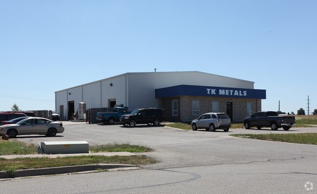
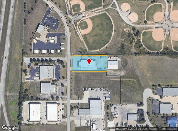
Property Record
8115 Monticello Ter, Lenexa, KS 66227
NEARBY LISTINGS FOR SALE OR LEASE
Property Detail
8115 Monticello Ter
Kansas City, MO-KS
K-7 Commercial Center
QP32600000-0004
K-7 COMMERCIAL CENTER N 167 LT 4 SHC 479 1 4
Warehouse
Johnson
X
Kansas
20091C0032G
4
2024
1.41 AC
2024
Lenexa
052611
Kansas City
17,550 SF
DEMOGRAPHICS near 8115 Monticello Ter
1 Mile
3 Mile
5 Mile
2024 Total Population
2,738
26,899
76,099
2029 Population
2,938
28,406
79,759
Pop Growth 2024-2029
+ 7.30%
+ 5.60%
+ 4.81%
Average Age
40
39
39
2024 Total Households
981
9,307
28,130
HH Growth 2024-2029
+ 7.44%
+ 5.80%
+ 4.87%
Median Household Inc
$123,863
$140,558
$126,590
Avg Household Size
2.70
2.90
2.70
2024 Avg HH Vehicles
2.00
2.00
2.00
Median Home Value
$406,987
$428,668
$395,346
Median Year Built
2007
2006
2003
Nearby Places
Map Layers
Map Styles
 Street
 Aerial
- Restaurants
- Banks
- Shops
- Fitness
- Groceries
PUBLIC TRANSPORTATION
AIRPORT
Kansas City International
DRIVE
WALK
Distance
Kansas City International
45 min
36.6 mi
Freight Ports
Tulsa Port Of Catoosa
DRIVE
WALK
Distance
Tulsa Port Of Catoosa
263 min
234.3 mi
Nearby Properties
Address
Land Use
TOTAL SIZE
Lot Size
Zoning
Address
Land Use
TOTAL SIZE
Lot Size
Zoning
163,515 SF
70.39 AC
R1
Address
Land Use
TOTAL SIZE
Lot Size
Zoning
202,945 SF
30.29 AC
AG
Address
Land Use
TOTAL SIZE
Lot Size
Zoning
106,283 SF
11.79 AC
R1
Address
Land Use
TOTAL SIZE
Lot Size
Zoning
91,639 SF
19.51 AC
R1
Address
Land Use
TOTAL SIZE
Lot Size
Zoning
69,675 SF
11.85 AC
R1
Address
Land Use
TOTAL SIZE
Lot Size
Zoning
32,186 SF
2.80 AC
CH
Address
Land Use
TOTAL SIZE
Lot Size
Zoning
100,591 SF
33.88 AC
AG
Address
Land Use
TOTAL SIZE
Lot Size
Zoning
67,336 SF
26.85 AC
AG
Address
Land Use
TOTAL SIZE
Lot Size
Zoning
42,261 SF
9.58 AC
R1
Address
Land Use
TOTAL SIZE
Lot Size
Zoning
99,600 SF
7.77 AC
PI
Address
Land Use
TOTAL SIZE
Lot Size
Zoning
75,626 SF
17.48 AC
AG
Address
Land Use
TOTAL SIZE
Lot Size
Zoning
79,697 SF
11.36 AC
PSF
Address
Land Use
TOTAL SIZE
Lot Size
Zoning
74,420 SF
20.04 AC
AG
Address
Land Use
TOTAL SIZE
Lot Size
Zoning
73,003 SF
15.62 AC
R1
Address
Land Use
TOTAL SIZE
Lot Size
Zoning
69,923 SF
11.99 AC
AG
Address
Land Use
TOTAL SIZE
Lot Size
Zoning
30,751 SF
9.73 AC
R1
Address
Land Use
TOTAL SIZE
Lot Size
Zoning
24,208 SF
8.13 AC
CPO
Address
Land Use
TOTAL SIZE
Lot Size
Zoning
28,707 SF
11.92 AC
R1
Address
Land Use
TOTAL SIZE
Lot Size
Zoning
52,710 SF
29.55 AC
AG
Address
Land Use
TOTAL SIZE
Lot Size
Zoning
4.93 AC
CTY RUR
Address
Land Use
TOTAL SIZE
Lot Size
Zoning
39,668 SF
6.02 AC
Address
Land Use
TOTAL SIZE
Lot Size
Zoning
483,724 SF
50.52 AC
BP
Address
Land Use
TOTAL SIZE
Lot Size
Zoning
24,478 SF
3.10 AC
R1
Address
Land Use
TOTAL SIZE
Lot Size
Zoning
20,832 SF
19.85 AC
AG
Address
Land Use
TOTAL SIZE
Lot Size
Zoning
13,500 SF
10.92 AC
R1
Address
Land Use
TOTAL SIZE
Lot Size
Zoning
12,746 SF
8.99 AC
AG
Address
Land Use
TOTAL SIZE
Lot Size
Zoning
19,003 SF
4.47 AC
CH
Address
Land Use
TOTAL SIZE
Lot Size
Zoning
28,390 SF
9.85 AC
AG
Address
Land Use
TOTAL SIZE
Lot Size
Zoning
16,078 SF
19.48 AC
PUDMR
Address
Land Use
TOTAL SIZE
Lot Size
Zoning
8,113 SF
1.31 AC
RPE
The World's #1 Commercial Real Estate Marketplace
Connect with us
© 2025 CoStar Group
The information above has been obtained from sources believed reliable. While we do not doubt its accuracy we have not verified it and make no guarantee, warranty or representation about it. It is your responsibility to independently confirm its accuracy and completeness. Any projections, opinions, assumptions, or estimates used are for example only and do not represent the current or future performance of the property. The value of this transaction to you depends on tax and other factors which should be evaluated by your tax, financial, and legal advisors. You and your advisors should conduct a careful, independent investigation of the property to determine to your satisfaction the suitability of the property for your needs.