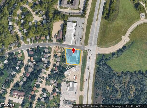
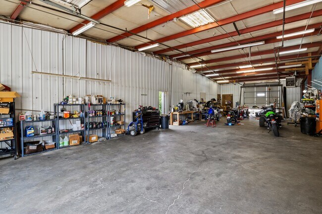
Property Record
812 Fort Crook Rd S, Bellevue, NE 68005
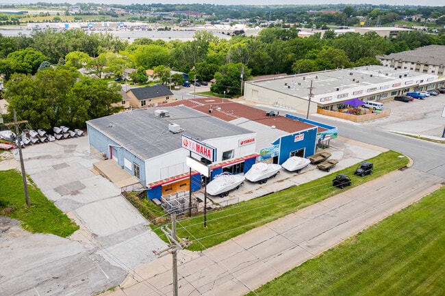
This Property Is For Sale
NEARBY LISTINGS FOR SALE OR LEASE
Property Detail
812 Fort Crook Rd S
Omaha-Council Bluffs, NE-IA
Twin Ridge Ii
010451137
LOT 3E TWIN RIDGE II
Commercialnec
Sarpy
X
Nebraska
31153C0093G
3e
2024
0.78 AC
2025
Sarpy East
010108
Omaha/Council Bluffs
11,808 SF
DEMOGRAPHICS near 812 Fort Crook Rd S
1 Mile
3 Mile
5 Mile
2024 Total Population
9,607
52,933
122,597
2029 Population
10,405
56,929
129,867
Pop Growth 2024-2029
+ 8.31%
+ 7.55%
+ 5.93%
Average Age
40
37
36
2024 Total Households
3,879
20,459
43,984
HH Growth 2024-2029
+ 8.48%
+ 7.77%
+ 6.25%
Median Household Inc
$58,902
$65,242
$69,338
Avg Household Size
2.40
2.50
2.70
2024 Avg HH Vehicles
2.00
2.00
2.00
Median Home Value
$191,831
$198,774
$209,765
Median Year Built
1977
1978
1979
Nearby Places
- Restaurants
- Banks
- Shops
- Fitness
- Groceries
PUBLIC TRANSPORTATION
COMMUTER RAIL
Omaha Amtrak Station (California Zephyr - Amtrak)
DRIVE
WALK
Distance
Omaha Amtrak Station (California Zephyr - Amtrak)
12 min
7.0 mi
Omaha Amtrak Station (California Zephyr - Amtrak)
DRIVE
WALK
Distance
Omaha Amtrak Station (California Zephyr - Amtrak)
13 min
7.2 mi
AIRPORT
Eppley Airfield
DRIVE
WALK
Distance
Eppley Airfield
22 min
12.9 mi
Freight Ports
Tulsa Port Of Catoosa
DRIVE
WALK
Distance
Tulsa Port Of Catoosa
455 min
411.5 mi
Nearby Properties
Address
Land Use
TOTAL SIZE
Lot Size
Zoning
Address
Land Use
TOTAL SIZE
Lot Size
Zoning
272,760 SF
2.40 AC
Address
Land Use
TOTAL SIZE
Lot Size
Zoning
276,509 SF
3.67 AC
Address
Land Use
TOTAL SIZE
Lot Size
Zoning
17,155 SF
13.11 AC
Address
Land Use
TOTAL SIZE
Lot Size
Zoning
24,969 SF
3.79 AC
RG20
Address
Land Use
TOTAL SIZE
Lot Size
Zoning
10,052 SF
9.38 AC
Address
Land Use
TOTAL SIZE
Lot Size
Zoning
3,906 SF
13.62 AC
RG20
Address
Land Use
TOTAL SIZE
Lot Size
Zoning
160,000 SF
22.48 AC
Address
Land Use
TOTAL SIZE
Lot Size
Zoning
18,727 SF
11.15 AC
RG20
Address
Land Use
TOTAL SIZE
Lot Size
Zoning
143 SF
17.56 AC
RG28
Address
Land Use
TOTAL SIZE
Lot Size
Zoning
254,734 SF
18.90 AC
Address
Land Use
TOTAL SIZE
Lot Size
Zoning
1,216 SF
22.82 AC
Address
Land Use
TOTAL SIZE
Lot Size
Zoning
18,825 SF
15.18 AC
Address
Land Use
TOTAL SIZE
Lot Size
Zoning
117,829 SF
11.13 AC
BG
Address
Land Use
TOTAL SIZE
Lot Size
Zoning
12.71 AC
Address
Land Use
TOTAL SIZE
Lot Size
Zoning
119,396 SF
13.46 AC
Address
Land Use
TOTAL SIZE
Lot Size
Zoning
226,320 SF
12.75 AC
Address
Land Use
TOTAL SIZE
Lot Size
Zoning
3.95 AC
Address
Land Use
TOTAL SIZE
Lot Size
Zoning
1,850 SF
8.14 AC
Address
Land Use
TOTAL SIZE
Lot Size
Zoning
400 SF
23.26 AC
Address
Land Use
TOTAL SIZE
Lot Size
Zoning
42,900 SF
16.25 AC
Address
Land Use
TOTAL SIZE
Lot Size
Zoning
2,032 SF
8.67 AC
Address
Land Use
TOTAL SIZE
Lot Size
Zoning
62,735 SF
0.65 AC
Address
Land Use
TOTAL SIZE
Lot Size
Zoning
212,990 SF
8.75 AC
MH
Address
Land Use
TOTAL SIZE
Lot Size
Zoning
88,232 SF
6.72 AC
BG
Address
Land Use
TOTAL SIZE
Lot Size
Zoning
1,103 SF
9.27 AC
Address
Land Use
TOTAL SIZE
Lot Size
Zoning
33,713 SF
14.39 AC
Address
Land Use
TOTAL SIZE
Lot Size
Zoning
63,669 SF
6.58 AC
Address
Land Use
TOTAL SIZE
Lot Size
Zoning
6,140 SF
7.05 AC
Address
Land Use
TOTAL SIZE
Lot Size
Zoning
4.53 AC
The World's #1 Commercial Real Estate Marketplace
Connect with us
© 2025 CoStar Group
The information above has been obtained from sources believed reliable. While we do not doubt its accuracy we have not verified it and make no guarantee, warranty or representation about it. It is your responsibility to independently confirm its accuracy and completeness. Any projections, opinions, assumptions, or estimates used are for example only and do not represent the current or future performance of the property. The value of this transaction to you depends on tax and other factors which should be evaluated by your tax, financial, and legal advisors. You and your advisors should conduct a careful, independent investigation of the property to determine to your satisfaction the suitability of the property for your needs.