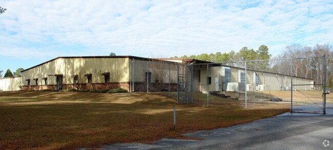
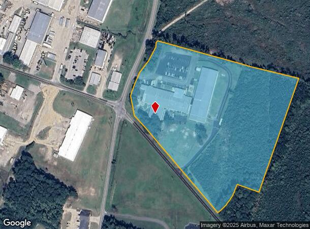
Property Record
812 Instrument Dr, Rocky Mount, NC 27804

NEARBY LISTINGS FOR SALE OR LEASE
Property Detail
812 Instrument Dr
3852-16-93-1468
Property Of George & Mina Finkelstein
Publicstorage
301 5 2 10, 15.26 AC, SUBURBIA IND PARK AC 1C SUBURBIA IND PARK
X
Nash
3720385200J
North Carolina
0
15.26 AC
2025
Rocky Mount/Wilson
010603
Other Market Areas
38,870 SF
Rocky Mount, NC
DEMOGRAPHICS near 812 Instrument Dr
1 Mile
3 Mile
5 Mile
2024 Total Population
1,778
10,791
34,540
2029 Population
1,831
11,091
35,394
Pop Growth 2024-2029
+ 2.98%
+ 2.78%
+ 2.47%
Average Age
36
40
41
2024 Total Households
709
4,736
15,009
HH Growth 2024-2029
+ 2.82%
+ 2.74%
+ 2.55%
Median Household Inc
$55,021
$60,735
$49,799
Avg Household Size
2.30
2.20
2.20
2024 Avg HH Vehicles
2.00
2.00
2.00
Median Home Value
$80,519
$147,429
$131,477
Median Year Built
1981
1984
1979
Nearby Places
Map Layers
Map Styles
 Street
 Aerial
- Restaurants
- Banks
- Shops
- Fitness
- Groceries
PUBLIC TRANSPORTATION
COMMUTER RAIL
Rocky Mount (Carolinian - Amtrak, Palmetto - Amtrak, Silver Meteor - Amtrak, Silver Star - Amtrak)
DRIVE
WALK
Distance
Rocky Mount (Carolinian - Amtrak, Palmetto - Amtrak, Silver Meteor - Amtrak, Silver Star - Amtrak)
10 min
5.3 mi
Freight Ports
Virginia Port Authority - Portsmouth
DRIVE
WALK
Distance
Virginia Port Authority - Portsmouth
155 min
131.7 mi
Nearby Properties
Address
Land Use
TOTAL SIZE
Lot Size
Zoning
Address
Land Use
TOTAL SIZE
Lot Size
Zoning
23,636 SF
111.07 AC
Address
Land Use
TOTAL SIZE
Lot Size
Zoning
3,072 SF
181.13 AC
Address
Land Use
TOTAL SIZE
Lot Size
Zoning
78,052 SF
122.10 AC
I2
Address
Land Use
TOTAL SIZE
Lot Size
Zoning
41,620 SF
32.43 AC
R30
Address
Land Use
TOTAL SIZE
Lot Size
Zoning
6,976 SF
15.97 AC
R6
Address
Land Use
TOTAL SIZE
Lot Size
Zoning
65,826 SF
16.77 AC
Address
Land Use
TOTAL SIZE
Lot Size
Zoning
204,903 SF
23.07 AC
Address
Land Use
TOTAL SIZE
Lot Size
Zoning
8,822 SF
9.70 AC
R6
Address
Land Use
TOTAL SIZE
Lot Size
Zoning
8,020 SF
13.81 AC
R6
Address
Land Use
TOTAL SIZE
Lot Size
Zoning
51,543 SF
9.61 AC
I
Address
Land Use
TOTAL SIZE
Lot Size
Zoning
120,560 SF
27.50 AC
I2
Address
Land Use
TOTAL SIZE
Lot Size
Zoning
7,952 SF
8.59 AC
R6
Address
Land Use
TOTAL SIZE
Lot Size
Zoning
253,009 SF
52.80 AC
B3
Address
Land Use
TOTAL SIZE
Lot Size
Zoning
36,151 SF
23.17 AC
R30
Address
Land Use
TOTAL SIZE
Lot Size
Zoning
70,557 SF
27.65 AC
I
Address
Land Use
TOTAL SIZE
Lot Size
Zoning
12,660 SF
95.06 AC
Address
Land Use
TOTAL SIZE
Lot Size
Zoning
60,793 SF
10.20 AC
I2
Address
Land Use
TOTAL SIZE
Lot Size
Zoning
113,921 SF
7.82 AC
B2
Address
Land Use
TOTAL SIZE
Lot Size
Zoning
107,334 SF
8.80 AC
B2
Address
Land Use
TOTAL SIZE
Lot Size
Zoning
310,108 SF
33.68 AC
I2
Address
Land Use
TOTAL SIZE
Lot Size
Zoning
68,032 SF
7.23 AC
B2
Address
Land Use
TOTAL SIZE
Lot Size
Zoning
35,635 SF
5 AC
B2
Address
Land Use
TOTAL SIZE
Lot Size
Zoning
69,902 SF
12.92 AC
B5
Address
Land Use
TOTAL SIZE
Lot Size
Zoning
134,452 SF
11.78 AC
Address
Land Use
TOTAL SIZE
Lot Size
Zoning
95,646 SF
8.44 AC
B2
Address
Land Use
TOTAL SIZE
Lot Size
Zoning
204,794 SF
14.85 AC
I2
Address
Land Use
TOTAL SIZE
Lot Size
Zoning
36,005 SF
2.93 AC
Address
Land Use
TOTAL SIZE
Lot Size
Zoning
4,371 SF
8.48 AC
R6
Address
Land Use
TOTAL SIZE
Lot Size
Zoning
25,432 SF
78.78 AC
Address
Land Use
TOTAL SIZE
Lot Size
Zoning
228,800 SF
19.48 AC
I2
The World's #1 Commercial Real Estate Marketplace
Connect with us
© 2025 CoStar Group
The information above has been obtained from sources believed reliable. While we do not doubt its accuracy we have not verified it and make no guarantee, warranty or representation about it. It is your responsibility to independently confirm its accuracy and completeness. Any projections, opinions, assumptions, or estimates used are for example only and do not represent the current or future performance of the property. The value of this transaction to you depends on tax and other factors which should be evaluated by your tax, financial, and legal advisors. You and your advisors should conduct a careful, independent investigation of the property to determine to your satisfaction the suitability of the property for your needs.