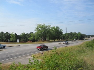
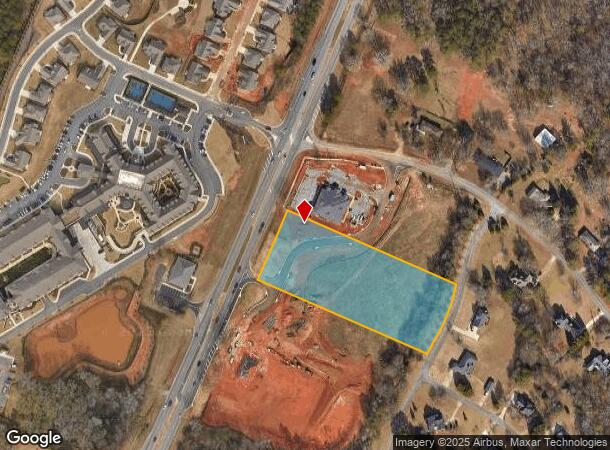
Property Record
8120 Macon Hwy, Athens, GA 30606
NEARBY LISTINGS FOR SALE OR LEASE
Property Detail
8120 Macon Hwy
Athens-Clarke County, GA
Lavista Office Park
C03-U0-01
1738/484 2023/71
Miscellaneous
Oconee
X
Georgia
13219C0070E
1
0
3.40 AC
2024
Athens/Gainesville
030201
Other Market Areas
DEMOGRAPHICS near 8120 Macon Hwy
1 Mile
3 Mile
5 Mile
2024 Total Population
1,337
22,490
88,121
2029 Population
1,499
23,994
91,007
Pop Growth 2024-2029
+ 12.12%
+ 6.69%
+ 3.28%
Average Age
38
37
35
2024 Total Households
469
8,443
34,264
HH Growth 2024-2029
+ 12.15%
+ 6.42%
+ 3.00%
Median Household Inc
$133,035
$74,901
$62,159
Avg Household Size
2.90
2.60
2.30
2024 Avg HH Vehicles
3.00
2.00
2.00
Median Home Value
$441,428
$354,326
$327,759
Median Year Built
1994
1991
1988
Nearby Places
Map Layers
Map Styles
 Street
 Aerial
- Restaurants
- Banks
- Shops
- Fitness
- Groceries
Nearby Properties
Address
Land Use
TOTAL SIZE
Lot Size
Zoning
Address
Land Use
TOTAL SIZE
Lot Size
Zoning
11,600 SF
154.32 AC
AR
Address
Land Use
TOTAL SIZE
Lot Size
Zoning
Address
Land Use
TOTAL SIZE
Lot Size
Zoning
1,956 SF
93.87 AC
RM-1
Address
Land Use
TOTAL SIZE
Lot Size
Zoning
107,030 SF
34.62 AC
AR
Address
Land Use
TOTAL SIZE
Lot Size
Zoning
17,356 SF
10.66 AC
B-2
Address
Land Use
TOTAL SIZE
Lot Size
Zoning
327.70 AC
G
Address
Land Use
TOTAL SIZE
Lot Size
Zoning
90,670 SF
11.86 AC
B-2
Address
Land Use
TOTAL SIZE
Lot Size
Zoning
12,483 SF
8.13 AC
Address
Land Use
TOTAL SIZE
Lot Size
Zoning
68,931 SF
5.56 AC
O-B-P
Address
Land Use
TOTAL SIZE
Lot Size
Zoning
11,520 SF
11.53 AC
RM-1
Address
Land Use
TOTAL SIZE
Lot Size
Zoning
58,725 SF
3.14 AC
B-2
Address
Land Use
TOTAL SIZE
Lot Size
Zoning
40,352 SF
32.66 AC
RM-1
Address
Land Use
TOTAL SIZE
Lot Size
Zoning
5,216 SF
12.81 AC
R-3
Address
Land Use
TOTAL SIZE
Lot Size
Zoning
15,552 SF
6.84 AC
RM-2
Address
Land Use
TOTAL SIZE
Lot Size
Zoning
154,871 SF
27.16 AC
B-1
Address
Land Use
TOTAL SIZE
Lot Size
Zoning
29,032 SF
14 AC
AG
Address
Land Use
TOTAL SIZE
Lot Size
Zoning
76,360 SF
10.25 AC
B-1
Address
Land Use
TOTAL SIZE
Lot Size
Zoning
37,572 SF
0.43 AC
O-B-P
Address
Land Use
TOTAL SIZE
Lot Size
Zoning
51,646 SF
3.53 AC
B-2
Address
Land Use
TOTAL SIZE
Lot Size
Zoning
36.39 AC
G
Address
Land Use
TOTAL SIZE
Lot Size
Zoning
78,525 SF
15.81 AC
Address
Land Use
TOTAL SIZE
Lot Size
Zoning
57,735 SF
35 AC
AG
Address
Land Use
TOTAL SIZE
Lot Size
Zoning
135,129 SF
14.75 AC
B-1
Address
Land Use
TOTAL SIZE
Lot Size
Zoning
37,572 SF
0.43 AC
O-B-P
Address
Land Use
TOTAL SIZE
Lot Size
Zoning
25,519 SF
7.63 AC
OIP
Address
Land Use
TOTAL SIZE
Lot Size
Zoning
45,945 SF
2.27 AC
OIP
Address
Land Use
TOTAL SIZE
Lot Size
Zoning
Address
Land Use
TOTAL SIZE
Lot Size
Zoning
60,603 SF
3.82 AC
RM-2
Address
Land Use
TOTAL SIZE
Lot Size
Zoning
47.47 AC
G
Address
Land Use
TOTAL SIZE
Lot Size
Zoning
59,031 SF
8.81 AC
B-2
The World's #1 Commercial Real Estate Marketplace
Connect with us
© 2025 CoStar Group
The information above has been obtained from sources believed reliable. While we do not doubt its accuracy we have not verified it and make no guarantee, warranty or representation about it. It is your responsibility to independently confirm its accuracy and completeness. Any projections, opinions, assumptions, or estimates used are for example only and do not represent the current or future performance of the property. The value of this transaction to you depends on tax and other factors which should be evaluated by your tax, financial, and legal advisors. You and your advisors should conduct a careful, independent investigation of the property to determine to your satisfaction the suitability of the property for your needs.