Property Record
8124 Greenly Dr, Oakland, CA 94605
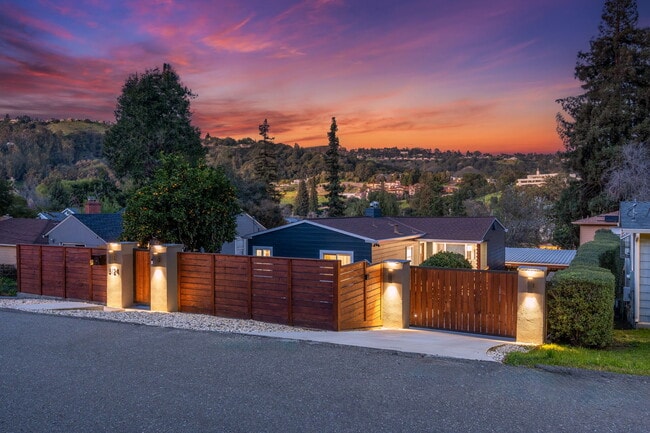


This Property Is For Sale
NEARBY LISTINGS FOR SALE OR LEASE
Property Detail
8124 Greenly Dr
Oakland-Hayward-Berkeley, CA
Melrose Hlnds
040A-3449-047-00
Alameda
Sfr
California
X
0.12 AC
06001C0095G
Middle East Oakland
1,719 SF
East Bay/Oakland
DEMOGRAPHICS near 8124 Greenly Dr
1 Mile
3 Mile
5 Mile
2024 Total Population
18,216
155,801
329,753
2029 Population
17,610
150,079
317,768
Pop Growth 2024-2029
(3.33%)
(3.67%)
(3.63%)
Average Age
40
39
40
2024 Total Households
6,580
50,286
110,127
HH Growth 2024-2029
(3.72%)
(4.08%)
(4.01%)
Median Household Inc
$100,508
$89,851
$96,203
Avg Household Size
2.70
2.90
2.80
2024 Avg HH Vehicles
2.00
2.00
2.00
Median Home Value
$826,371
$805,440
$879,966
Median Year Built
1956
1952
1953
Nearby Places
Map Layers
Map Styles
 Street
 Aerial
- Restaurants
- Banks
- Shops
- Fitness
- Groceries
PUBLIC TRANSPORTATION
COMMUTER RAIL
Oakland (Capitol Corridor - Amtrak, Coast Starlight - Amtrak, San Joaquins - Amtrak)
DRIVE
WALK
Distance
Oakland (Capitol Corridor - Amtrak, Coast Starlight - Amtrak, San Joaquins - Amtrak)
14 min
8.1 mi
Hayward Amtrak (Capitol Corridor - Amtrak)
DRIVE
WALK
Distance
Hayward Amtrak (Capitol Corridor - Amtrak)
16 min
9.9 mi
AIRPORT
Metro Oakland International
DRIVE
WALK
Distance
Metro Oakland International
12 min
7.2 mi
San Francisco International
DRIVE
WALK
Distance
San Francisco International
42 min
31.6 mi
Freight Ports
Port of Oakland
DRIVE
WALK
Distance
Port of Oakland
15 min
9.2 mi
Nearby Properties
Address
Land Use
TOTAL SIZE
Lot Size
Zoning
Address
Land Use
TOTAL SIZE
Lot Size
Zoning
534,208 SF
23.18 AC
Address
Land Use
TOTAL SIZE
Lot Size
Zoning
1.64 AC
Address
Land Use
TOTAL SIZE
Lot Size
Zoning
525,864 SF
16.53 AC
Address
Land Use
TOTAL SIZE
Lot Size
Zoning
336,680 SF
9.93 AC
M40
Address
Land Use
TOTAL SIZE
Lot Size
Zoning
99,039 SF
1.04 AC
Address
Land Use
TOTAL SIZE
Lot Size
Zoning
284,255 SF
5.07 AC
Address
Land Use
TOTAL SIZE
Lot Size
Zoning
214,062 SF
16.20 AC
Address
Land Use
TOTAL SIZE
Lot Size
Zoning
133,678 SF
4.33 AC
Address
Land Use
TOTAL SIZE
Lot Size
Zoning
231,756 SF
9.15 AC
Address
Land Use
TOTAL SIZE
Lot Size
Zoning
232,068 SF
31.82 AC
Address
Land Use
TOTAL SIZE
Lot Size
Zoning
129,726 SF
5.38 AC
Address
Land Use
TOTAL SIZE
Lot Size
Zoning
0.94 AC
Address
Land Use
TOTAL SIZE
Lot Size
Zoning
12,338 SF
65.10 AC
Address
Land Use
TOTAL SIZE
Lot Size
Zoning
83,319 SF
0.53 AC
Address
Land Use
TOTAL SIZE
Lot Size
Zoning
204,006 SF
6.39 AC
M40
Address
Land Use
TOTAL SIZE
Lot Size
Zoning
117,518 SF
7.99 AC
Address
Land Use
TOTAL SIZE
Lot Size
Zoning
132,446 SF
4.34 AC
Address
Land Use
TOTAL SIZE
Lot Size
Zoning
6.81 AC
Address
Land Use
TOTAL SIZE
Lot Size
Zoning
64,421 SF
3.49 AC
Address
Land Use
TOTAL SIZE
Lot Size
Zoning
152,535 SF
1.86 AC
Address
Land Use
TOTAL SIZE
Lot Size
Zoning
52,206 SF
0.49 AC
Address
Land Use
TOTAL SIZE
Lot Size
Zoning
47,468 SF
2.51 AC
Address
Land Use
TOTAL SIZE
Lot Size
Zoning
273,468 SF
9.49 AC
Address
Land Use
TOTAL SIZE
Lot Size
Zoning
148,060 SF
4.81 AC
Address
Land Use
TOTAL SIZE
Lot Size
Zoning
82,043 SF
1.66 AC
Address
Land Use
TOTAL SIZE
Lot Size
Zoning
25.73 AC
Address
Land Use
TOTAL SIZE
Lot Size
Zoning
96,676 SF
1.72 AC
Address
Land Use
TOTAL SIZE
Lot Size
Zoning
83,319 SF
0.25 AC
Address
Land Use
TOTAL SIZE
Lot Size
Zoning
5.73 AC
Address
Land Use
TOTAL SIZE
Lot Size
Zoning
178,939 SF
9.75 AC
The World's #1 Commercial Real Estate Marketplace
Connect with us
© 2025 CoStar Group
The information above has been obtained from sources believed reliable. While we do not doubt its accuracy we have not verified it and make no guarantee, warranty or representation about it. It is your responsibility to independently confirm its accuracy and completeness. Any projections, opinions, assumptions, or estimates used are for example only and do not represent the current or future performance of the property. The value of this transaction to you depends on tax and other factors which should be evaluated by your tax, financial, and legal advisors. You and your advisors should conduct a careful, independent investigation of the property to determine to your satisfaction the suitability of the property for your needs.