Property Record
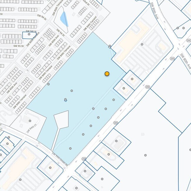
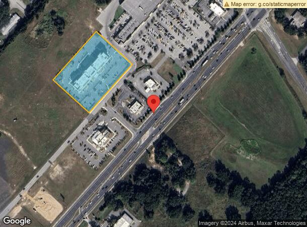
8125 Sw Highway 200, Ocala, FL 34481
NEARBY LISTINGS FOR SALE OR LEASE
Property Detail
8125 Sw Highway 200
Ocala, FL
Canopy Oaks Phase Ii
3530-1001-08
SEC 24 TWP 16 RGE 20 PLAT BOOK 014 PAGE 073 CANOPY OAKS PHASE II REPLAT LOT 7
Hotel
Marion
X
Florida
12083C0684E
7
2024
3.33 AC
2025
Outlying Marion County
002609
Ocala
68,278 SF
DEMOGRAPHICS near 8125 Sw Highway 200
1 Mile
3 Mile
5 Mile
2024 Total Population
5,651
34,060
54,755
2029 Population
6,368
38,621
62,251
Pop Growth 2024-2029
+ 12.69%
+ 13.39%
+ 13.69%
Average Age
67
63
56
2024 Total Households
3,202
17,819
26,130
HH Growth 2024-2029
+ 12.71%
+ 13.29%
+ 13.52%
Median Household Inc
$46,172
$55,333
$59,003
Avg Household Size
1.70
1.90
2.10
2024 Avg HH Vehicles
1.00
1.00
2.00
Median Home Value
$158,185
$194,751
$205,267
Median Year Built
1991
1996
1999
Nearby Places
Map Layers
Map Styles
 Street
 Aerial
- Restaurants
- Banks
- Shops
- Fitness
- Groceries
Nearby Properties
Address
Land Use
TOTAL SIZE
Lot Size
Zoning
Address
Land Use
TOTAL SIZE
Lot Size
Zoning
380,749 SF
40.05 AC
PUD
Address
Land Use
TOTAL SIZE
Lot Size
Zoning
304,259 SF
31.62 AC
PUD
Address
Land Use
TOTAL SIZE
Lot Size
Zoning
96,094 SF
13.66 AC
B2
Address
Land Use
TOTAL SIZE
Lot Size
Zoning
62,253 SF
6.52 AC
PUD
Address
Land Use
TOTAL SIZE
Lot Size
Zoning
103,410 SF
27.04 AC
PUD
Address
Land Use
TOTAL SIZE
Lot Size
Zoning
74,928 SF
7.80 AC
PUD
Address
Land Use
TOTAL SIZE
Lot Size
Zoning
210,937 SF
27.08 AC
B4
Address
Land Use
TOTAL SIZE
Lot Size
Zoning
28,813 SF
70.30 AC
B4
Address
Land Use
TOTAL SIZE
Lot Size
Zoning
18,035 SF
3.33 AC
B2
Address
Land Use
TOTAL SIZE
Lot Size
Zoning
43,619 SF
6.04 AC
R3
Address
Land Use
TOTAL SIZE
Lot Size
Zoning
139,728 SF
22.86 AC
B4
Address
Land Use
TOTAL SIZE
Lot Size
Zoning
101,312 SF
5,201.15 AC
A1
Address
Land Use
TOTAL SIZE
Lot Size
Zoning
65,060 SF
11.90 AC
B2
Address
Land Use
TOTAL SIZE
Lot Size
Zoning
98,205 SF
13.41 AC
B2
Address
Land Use
TOTAL SIZE
Lot Size
Zoning
77,877 SF
13.38 AC
B2
Address
Land Use
TOTAL SIZE
Lot Size
Zoning
88,777 SF
10.50 AC
B4
Address
Land Use
TOTAL SIZE
Lot Size
Zoning
69,278 SF
7.52 AC
B4
Address
Land Use
TOTAL SIZE
Lot Size
Zoning
42,673 SF
13.72 AC
A1
Address
Land Use
TOTAL SIZE
Lot Size
Zoning
42,159 SF
5.95 AC
B2
Address
Land Use
TOTAL SIZE
Lot Size
Zoning
68,180 SF
5.40 AC
B5
Address
Land Use
TOTAL SIZE
Lot Size
Zoning
82,465 SF
6.13 AC
B2
Address
Land Use
TOTAL SIZE
Lot Size
Zoning
82,904 SF
10.51 AC
B2
Address
Land Use
TOTAL SIZE
Lot Size
Zoning
16,729 SF
5 AC
B4
Address
Land Use
TOTAL SIZE
Lot Size
Zoning
27,563 SF
3.03 AC
B4
Address
Land Use
TOTAL SIZE
Lot Size
Zoning
47,378 SF
23.26 AC
A1
Address
Land Use
TOTAL SIZE
Lot Size
Zoning
286.80 AC
PUD
Address
Land Use
TOTAL SIZE
Lot Size
Zoning
58,381 SF
5.12 AC
R3
Address
Land Use
TOTAL SIZE
Lot Size
Zoning
16,214 SF
4.91 AC
B2
Address
Land Use
TOTAL SIZE
Lot Size
Zoning
38,062 SF
3.07 AC
B2
Address
Land Use
TOTAL SIZE
Lot Size
Zoning
37,213 SF
14.54 AC
A1
The World's #1 Commercial Real Estate Marketplace
Connect with us
© 2026 CoStar Group
The information above has been obtained from sources believed reliable. While we do not doubt its accuracy we have not verified it and make no guarantee, warranty or representation about it. It is your responsibility to independently confirm its accuracy and completeness. Any projections, opinions, assumptions, or estimates used are for example only and do not represent the current or future performance of the property. The value of this transaction to you depends on tax and other factors which should be evaluated by your tax, financial, and legal advisors. You and your advisors should conduct a careful, independent investigation of the property to determine to your satisfaction the suitability of the property for your needs.