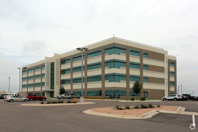
Property Record
8125 Up River Rd, Corpus Christi, TX 78409

Property Detail
8125 Up River Rd
Corpus Christi, TX
FLINT HILLS TRACT PT BLK 1 LOT 1 (SEE 2460-1-15 FOR ICL PORTION)
536500
NUECES
Industrialgeneral
Texas
B and X Area of moderate flood hazard, usually the area between the limits of the 100-year and 500-year floods.
1
2024
6 AC
2025
Northwest
006300
Corpus Christi
141,800 SF
NEARBY LISTINGS FOR SALE OR LEASE
-
-
View all Corpus Christi listings for sale on LoopNet.com
DEMOGRAPHICS near 8125 Up River Rd
1 mile
3 mile
5 mile
2025 Total Population
818
7,222
25,852
2030 Population
825
7,259
25,703
Pop Growth 2025-2030
+ 0.86%
+ 0.51%
(0.58%)
Average Age
39
37
37
2025 Total Households
287
2,500
9,269
HH Growth 2025-2030
+ 0.70%
+ 0.32%
(0.87%)
Median Household Inc
$68,225
$78,557
$62,702
Avg Household Size
2.80
2.80
2.70
2025 Avg HH Vehicles
2.00
2.00
2.00
Median Home Value
$136,301
$210,468
$186,189
Median Year Built
1977
1997
1985
Nearby Places
Map Layers
Map Styles
 Street
 Aerial
Layers
 Traffic
 Biking
Places
Listings with unknown addresses are not visible on the map
- Restaurants
- Banks
- Shops
- Fitness
- Groceries
PUBLIC TRANSPORTATION
AIRPORT
Corpus Christi International
Drive
Walk
Distance
Corpus Christi International
13 min
8.1 mi
Freight Ports
Port of Corpus Christi
Drive
Walk
Distance
Port of Corpus Christi
12 min
8.8 mi
Nearby Properties
Address
Land Use
TOTAL SIZE
Lot Size
Zoning
Address
Land Use
TOTAL SIZE
Lot Size
Zoning
126,708 SF
18.17 AC
R1B
Address
Land Use
TOTAL SIZE
Lot Size
Zoning
191,500 SF
14.33 AC
R1B
Address
Land Use
TOTAL SIZE
Lot Size
Zoning
368.71 AC
OCL
Address
Land Use
TOTAL SIZE
Lot Size
Zoning
600.26 AC
Address
Land Use
TOTAL SIZE
Lot Size
Zoning
Address
Land Use
TOTAL SIZE
Lot Size
Zoning
234.07 AC
OCL
Address
Land Use
TOTAL SIZE
Lot Size
Zoning
276.16 AC
R1B
Address
Land Use
TOTAL SIZE
Lot Size
Zoning
139.72 AC
OCL
Address
Land Use
TOTAL SIZE
Lot Size
Zoning
71,839 SF
30.18 AC
Address
Land Use
TOTAL SIZE
Lot Size
Zoning
26,200 SF
4.86 AC
I-2
Address
Land Use
TOTAL SIZE
Lot Size
Zoning
151,918 SF
10 AC
I-3
Address
Land Use
TOTAL SIZE
Lot Size
Zoning
119.40 AC
OCL
Address
Land Use
TOTAL SIZE
Lot Size
Zoning
20,744 SF
23.64 AC
Address
Land Use
TOTAL SIZE
Lot Size
Zoning
96.23 AC
OCL
Address
Land Use
TOTAL SIZE
Lot Size
Zoning
167.06 AC
Address
Land Use
TOTAL SIZE
Lot Size
Zoning
66,052 SF
23.95 AC
I2SP08
Address
Land Use
TOTAL SIZE
Lot Size
Zoning
7,400 SF
43.16 AC
OCL
Address
Land Use
TOTAL SIZE
Lot Size
Zoning
36.26 AC
OCL
Address
Land Use
TOTAL SIZE
Lot Size
Zoning
81.50 AC
OCL
Address
Land Use
TOTAL SIZE
Lot Size
Zoning
39,858 SF
29 AC
Address
Land Use
TOTAL SIZE
Lot Size
Zoning
29,400 SF
35.99 AC
Address
Land Use
TOTAL SIZE
Lot Size
Zoning
76.13 AC
OCL
Address
Land Use
TOTAL SIZE
Lot Size
Zoning
14,765 SF
80 AC
R1B
Address
Land Use
TOTAL SIZE
Lot Size
Zoning
68.37 AC
OCL
Address
Land Use
TOTAL SIZE
Lot Size
Zoning
38,279 SF
5.01 AC
Address
Land Use
TOTAL SIZE
Lot Size
Zoning
62.55 AC
OCL
Address
Land Use
TOTAL SIZE
Lot Size
Zoning
65,982 SF
9.13 AC
I-Z
Address
Land Use
TOTAL SIZE
Lot Size
Zoning
Address
Land Use
TOTAL SIZE
Lot Size
Zoning
19.29 AC
OCL
The World's #1 Commercial Real Estate Marketplace
Connect with us
© 2026 CoStar Group
The information above has been obtained from sources believed reliable. While we do not doubt its accuracy we have not verified it and make no guarantee, warranty or representation about it. It is your responsibility to independently confirm its accuracy and completeness. Any projections, opinions, assumptions, or estimates used are for example only and do not represent the current or future performance of the property. The value of this transaction to you depends on tax and other factors which should be evaluated by your tax, financial, and legal advisors. You and your advisors should conduct a careful, independent investigation of the property to determine to your satisfaction the suitability of the property for your needs.