Property Record
8127 E 590 Rd, Catoosa, OK 74015

Property Detail
8127 E 590 Rd
660030410
TR IN SE SW SW, BEG 335.61' W OF SE/C SW SW, N 518.82', W 169.53', S 511.92', E 169.40' TO POB
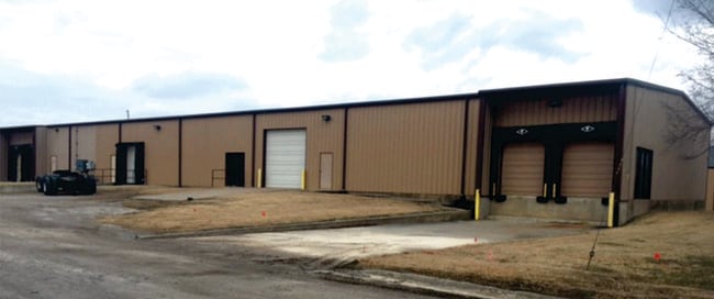
Warehouse
ROGERS
B and X Area of moderate flood hazard, usually the area between the limits of the 100-year and 500-year floods.
Oklahoma
2025
2 AC
2025
Rogers County
050409
Tulsa
5,000 SF
Tulsa, OK
NEARBY LISTINGS FOR SALE OR LEASE
-
-
View all Catoosa listings for lease on LoopNet.com
DEMOGRAPHICS near 8127 E 590 Rd
1 mile
3 mile
5 mile
2025 Total Population
434
3,992
19,334
2030 Population
471
4,358
20,759
Pop Growth 2025-2030
+ 8.53%
+ 9.17%
+ 7.37%
Average Age
43
43
39
2025 Total Households
161
1,472
7,083
HH Growth 2025-2030
+ 8.70%
+ 9.10%
+ 7.21%
Median Household Inc
$64,091
$74,394
$76,059
Avg Household Size
2.60
2.60
2.70
2025 Avg HH Vehicles
3.00
3.00
2.00
Median Home Value
$266,071
$242,910
$224,938
Median Year Built
1993
1993
1993
Nearby Places
Map Layers
Map Styles
 Street
 Aerial
Layers
 Traffic
 Biking
Places
Listings with unknown addresses are not visible on the map
- Restaurants
- Banks
- Shops
- Fitness
- Groceries
PUBLIC TRANSPORTATION
AIRPORT
Tulsa International
Drive
Walk
Distance
Tulsa International
24 min
17.1 mi
Freight Ports
Drive
Walk
Distance
17 min
10.7 mi
SALE & LEASE HISTORY
LISTING DATE
SALE/LEASE

Jul 05, 2019
For Lease
Nearby Properties
Address
Land Use
TOTAL SIZE
Lot Size
Zoning
Address
Land Use
TOTAL SIZE
Lot Size
Zoning
Address
Land Use
TOTAL SIZE
Lot Size
Zoning
707 SF
Address
Land Use
TOTAL SIZE
Lot Size
Zoning
2,400 SF
2 AC
Address
Land Use
TOTAL SIZE
Lot Size
Zoning
2,400 SF
2.78 AC
Address
Land Use
TOTAL SIZE
Lot Size
Zoning
12,600 SF
Address
Land Use
TOTAL SIZE
Lot Size
Zoning
8,968 SF
1.33 AC
Address
Land Use
TOTAL SIZE
Lot Size
Zoning
12,464 SF
50.46 AC
Address
Land Use
TOTAL SIZE
Lot Size
Zoning
3,200 SF
2.57 AC
Address
Land Use
TOTAL SIZE
Lot Size
Zoning
3,996 SF
2.02 AC
Address
Land Use
TOTAL SIZE
Lot Size
Zoning
6,000 SF
7.43 AC
Address
Land Use
TOTAL SIZE
Lot Size
Zoning
1,390 SF
7 AC
Address
Land Use
TOTAL SIZE
Lot Size
Zoning
1,536 SF
60 AC
Address
Land Use
TOTAL SIZE
Lot Size
Zoning
3,064 SF
2.32 AC
Address
Land Use
TOTAL SIZE
Lot Size
Zoning
9,480 SF
1.93 AC
Address
Land Use
TOTAL SIZE
Lot Size
Zoning
1,248 SF
6.90 AC
Address
Land Use
TOTAL SIZE
Lot Size
Zoning
24,500 SF
1.80 AC
Address
Land Use
TOTAL SIZE
Lot Size
Zoning
1,500 SF
5.86 AC
Address
Land Use
TOTAL SIZE
Lot Size
Zoning
1,120 SF
1.40 AC
Address
Land Use
TOTAL SIZE
Lot Size
Zoning
1,800 SF
1.01 AC
Address
Land Use
TOTAL SIZE
Lot Size
Zoning
6,000 SF
2 AC
Address
Land Use
TOTAL SIZE
Lot Size
Zoning
1,920 SF
0.82 AC
Address
Land Use
TOTAL SIZE
Lot Size
Zoning
764 SF
8.57 AC
Address
Land Use
TOTAL SIZE
Lot Size
Zoning
1,200 SF
3.24 AC
Address
Land Use
TOTAL SIZE
Lot Size
Zoning
Address
Land Use
TOTAL SIZE
Lot Size
Zoning
2,400 SF
5 AC
Address
Land Use
TOTAL SIZE
Lot Size
Zoning
25.07 AC
Address
Land Use
TOTAL SIZE
Lot Size
Zoning
1.52 AC
Address
Land Use
TOTAL SIZE
Lot Size
Zoning
1,500 SF
2 AC
The World's #1 Commercial Real Estate Marketplace
Connect with us
© 2026 CoStar Group
The information above has been obtained from sources believed reliable. While we do not doubt its accuracy we have not verified it and make no guarantee, warranty or representation about it. It is your responsibility to independently confirm its accuracy and completeness. Any projections, opinions, assumptions, or estimates used are for example only and do not represent the current or future performance of the property. The value of this transaction to you depends on tax and other factors which should be evaluated by your tax, financial, and legal advisors. You and your advisors should conduct a careful, independent investigation of the property to determine to your satisfaction the suitability of the property for your needs.