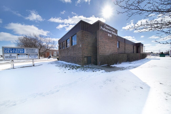
Property Record
8130 Constitution Blvd, Sterling Heights, MI 48313

Property Detail
8130 Constitution Blvd
10-10-15-151-015
$T2N,R12E, SEC 15 COMM AT W 1/4 POST SEC 15; TH N0*48'15"E 1001.14 FT; TH S89*59'30"E 260.0 FT TO PT OF BEG; TH N0*48'15"E
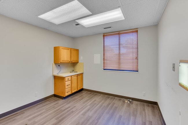
Medicalbuilding
Macomb
C-3
Michigan
B and X Area of moderate flood hazard, usually the area between the limits of the 100-year and 500-year floods.
0.68 AC
2025
Macomb West
2026
Detroit
230902
Detroit-Warren-Dearborn, MI
7,600 SF
NEARBY LISTINGS FOR SALE OR LEASE
DEMOGRAPHICS near 8130 Constitution Blvd
1 mile
3 mile
5 mile
2025 Total Population
11,043
99,361
275,476
2030 Population
11,548
99,945
278,518
Pop Growth 2025-2030
+ 4.57%
+ 0.59%
+ 1.10%
Average Age
41
42
43
2025 Total Households
4,514
37,882
110,733
HH Growth 2025-2030
+ 4.19%
+ 0.63%
+ 1.22%
Median Household Inc
$80,826
$80,494
$77,897
Avg Household Size
2.40
2.60
2.40
2025 Avg HH Vehicles
2.00
2.00
2.00
Median Home Value
$240,367
$268,074
$271,852
Median Year Built
1973
1976
1978
Nearby Places
Map Layers
Map Styles
 Street
 Aerial
Layers
 Traffic
 Biking
Places
Listings with unknown addresses are not visible on the map
- Restaurants
- Banks
- Shops
- Fitness
- Groceries
PUBLIC TRANSPORTATION
AIRPORT
Windsor International
Drive
Walk
Distance
Windsor International
57 min
33.1 mi
Detroit Metro Wayne County
Drive
Walk
Distance
Detroit Metro Wayne County
61 min
42.6 mi
SALE & LEASE HISTORY
LISTING DATE
SALE/LEASE

Sep 29, 2022
For Sale
Mar 03, 2020
For Sale
Feb 14, 2022
For Sale
Feb 12, 2025
For Lease
Feb 12, 2025
For Sale
Aug 08, 2025
For Sale
Aug 07, 2023
For Sale
Nearby Properties
Address
Land Use
TOTAL SIZE
Lot Size
Zoning
Address
Land Use
TOTAL SIZE
Lot Size
Zoning
920,611 SF
M-2
Address
Land Use
TOTAL SIZE
Lot Size
Zoning
1,024,233 SF
287.20 AC
M-2
Address
Land Use
TOTAL SIZE
Lot Size
Zoning
2,726,159 SF
199.39 AC
M-2
Address
Land Use
TOTAL SIZE
Lot Size
Zoning
146.36 AC
MHP
Address
Land Use
TOTAL SIZE
Lot Size
Zoning
92.30 AC
MHP
Address
Land Use
TOTAL SIZE
Lot Size
Zoning
2,727,131 SF
155.26 AC
M-2
Address
Land Use
TOTAL SIZE
Lot Size
Zoning
2,058,062 SF
141.65 AC
M-2
Address
Land Use
TOTAL SIZE
Lot Size
Zoning
283,249 SF
M-2
Address
Land Use
TOTAL SIZE
Lot Size
Zoning
229,624 SF
13.55 AC
M-2
Address
Land Use
TOTAL SIZE
Lot Size
Zoning
25.18 AC
RM-2
Address
Land Use
TOTAL SIZE
Lot Size
Zoning
242,857 SF
9.61 AC
RM-3
Address
Land Use
TOTAL SIZE
Lot Size
Zoning
1,150 SF
25.68 AC
CK MAP
Address
Land Use
TOTAL SIZE
Lot Size
Zoning
423,027 SF
46.73 AC
M-1
Address
Land Use
TOTAL SIZE
Lot Size
Zoning
2,984,492 SF
M-2
Address
Land Use
TOTAL SIZE
Lot Size
Zoning
438,578 SF
36.60 AC
MXD
Address
Land Use
TOTAL SIZE
Lot Size
Zoning
203,282 SF
17.13 AC
C-2
Address
Land Use
TOTAL SIZE
Lot Size
Zoning
98,265 SF
7.04 AC
RM-2
Address
Land Use
TOTAL SIZE
Lot Size
Zoning
148,330 SF
37.86 AC
RM-2
Address
Land Use
TOTAL SIZE
Lot Size
Zoning
201,873 SF
M-1
Address
Land Use
TOTAL SIZE
Lot Size
Zoning
139,846 SF
16 AC
RM-2
Address
Land Use
TOTAL SIZE
Lot Size
Zoning
559,929 SF
41.57 AC
M-1
Address
Land Use
TOTAL SIZE
Lot Size
Zoning
29.93 AC
RM-2
Address
Land Use
TOTAL SIZE
Lot Size
Zoning
16.11 AC
RM-2
Address
Land Use
TOTAL SIZE
Lot Size
Zoning
210,000 SF
M-1
Address
Land Use
TOTAL SIZE
Lot Size
Zoning
159,750 SF
16.76 AC
M-1
Address
Land Use
TOTAL SIZE
Lot Size
Zoning
21.03 AC
RM-2
Address
Land Use
TOTAL SIZE
Lot Size
Zoning
133,173 SF
8 AC
O-3
Address
Land Use
TOTAL SIZE
Lot Size
Zoning
200,000 SF
17.66 AC
M-2
Address
Land Use
TOTAL SIZE
Lot Size
Zoning
207,424 SF
11.96 AC
RM-2
Address
Land Use
TOTAL SIZE
Lot Size
Zoning
128,364 SF
40.11 AC
C-4
The World's #1 Commercial Real Estate Marketplace
Connect with us
© 2026 CoStar Group
The information above has been obtained from sources believed reliable. While we do not doubt its accuracy we have not verified it and make no guarantee, warranty or representation about it. It is your responsibility to independently confirm its accuracy and completeness. Any projections, opinions, assumptions, or estimates used are for example only and do not represent the current or future performance of the property. The value of this transaction to you depends on tax and other factors which should be evaluated by your tax, financial, and legal advisors. You and your advisors should conduct a careful, independent investigation of the property to determine to your satisfaction the suitability of the property for your needs.