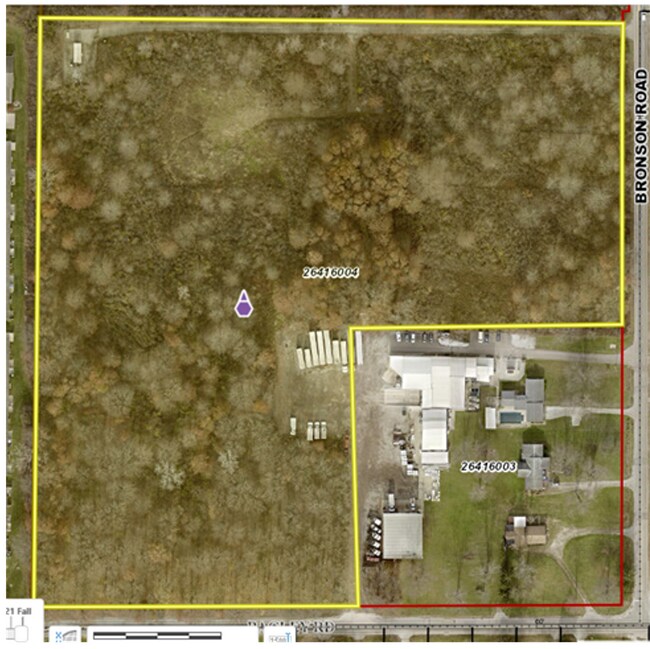
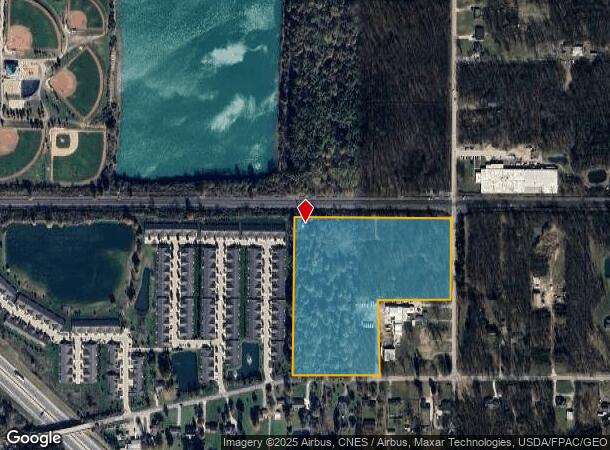
Property Record
8134 Bronson Rd, Olmsted Twp, OH 44138
NEARBY LISTINGS FOR SALE OR LEASE
Property Detail
8134 Bronson Rd
Cleveland-Elyria, OH
Olmsted 04
264-16-004
4-2 SWP
Commercialnec
Cuyahoga
X
Ohio
39035C0138E
4
2024
15.34 AC
2024
Southwest
190506
Cleveland
DEMOGRAPHICS near 8134 Bronson Rd
1 mile
3 mile
5 mile
2024 Total Population
3,287
41,617
100,235
2029 Population
3,332
41,784
100,984
Pop Growth 2024-2029
+ 1.37%
+ 0.40%
+ 0.75%
Average Age
47
43
43
2024 Total Households
1,451
16,706
40,068
HH Growth 2024-2029
+ 1.10%
+ 0.42%
+ 0.59%
Median Household Inc
$92,659
$83,747
$87,152
Avg Household Size
2.20
2.40
2.40
2024 Avg HH Vehicles
2.00
2.00
2.00
Median Home Value
$260,747
$206,111
$226,415
Median Year Built
1999
1980
1983
Nearby Places
Map Layers
Map Styles
 Street
 Aerial
Transit
 Traffic
 Biking
Places
Listings with unknown addresses are not visible on the map
- Restaurants
- Banks
- Shops
- Fitness
- Groceries
PUBLIC TRANSPORTATION
COMMUTER RAIL
Elyria Amtrak (Capitol Limited - Amtrak, Lake Shore Limited - Amtrak)
Drive
Walk
Distance
Elyria Amtrak (Capitol Limited - Amtrak, Lake Shore Limited - Amtrak)
17 min
8.2 mi
AIRPORT
Cleveland-Hopkins International
Drive
Walk
Distance
Cleveland-Hopkins International
19 min
9.9 mi
Freight Ports
Port of Toledo
Drive
Walk
Distance
Port of Toledo
115 min
96.1 mi
SALE & LEASE HISTORY
LISTING DATE
SALE/LEASE

Jul 28, 2022
For Sale
Nearby Properties
Address
Land Use
TOTAL SIZE
Lot Size
Zoning
Address
Land Use
TOTAL SIZE
Lot Size
Zoning
278,056 SF
42.71 AC
R-40
Address
Land Use
TOTAL SIZE
Lot Size
Zoning
195,990 SF
46.88 AC
RMF-A
Address
Land Use
TOTAL SIZE
Lot Size
Zoning
176,857 SF
8.62 AC
B-2
Address
Land Use
TOTAL SIZE
Lot Size
Zoning
46,133 SF
35.03 AC
RMF-A
Address
Land Use
TOTAL SIZE
Lot Size
Zoning
209,822 SF
26.92 AC
R-40
Address
Land Use
TOTAL SIZE
Lot Size
Zoning
50,668 SF
9.04 AC
Address
Land Use
TOTAL SIZE
Lot Size
Zoning
128,416 SF
13.42 AC
R-40
Address
Land Use
TOTAL SIZE
Lot Size
Zoning
43,950 SF
9.40 AC
Address
Land Use
TOTAL SIZE
Lot Size
Zoning
39,418 SF
6.05 AC
Address
Land Use
TOTAL SIZE
Lot Size
Zoning
57,126 SF
11.74 AC
Address
Land Use
TOTAL SIZE
Lot Size
Zoning
18,697 SF
4.47 AC
Address
Land Use
TOTAL SIZE
Lot Size
Zoning
73,673 SF
6.80 AC
SR
Address
Land Use
TOTAL SIZE
Lot Size
Zoning
27,445 SF
2 AC
Address
Land Use
TOTAL SIZE
Lot Size
Zoning
50,064 SF
15.73 AC
Address
Land Use
TOTAL SIZE
Lot Size
Zoning
99,422 SF
13.77 AC
Address
Land Use
TOTAL SIZE
Lot Size
Zoning
37,746 SF
9.42 AC
Address
Land Use
TOTAL SIZE
Lot Size
Zoning
49,926 SF
18.42 AC
Address
Land Use
TOTAL SIZE
Lot Size
Zoning
29,024 SF
7.29 AC
Address
Land Use
TOTAL SIZE
Lot Size
Zoning
55,496 SF
6.29 AC
CRG
Address
Land Use
TOTAL SIZE
Lot Size
Zoning
93,980 SF
12.48 AC
Address
Land Use
TOTAL SIZE
Lot Size
Zoning
121,778 SF
23.40 AC
D-3
Address
Land Use
TOTAL SIZE
Lot Size
Zoning
8,526 SF
5.19 AC
Address
Land Use
TOTAL SIZE
Lot Size
Zoning
Address
Land Use
TOTAL SIZE
Lot Size
Zoning
24,326 SF
7.54 AC
Address
Land Use
TOTAL SIZE
Lot Size
Zoning
11,984 SF
2.07 AC
Address
Land Use
TOTAL SIZE
Lot Size
Zoning
20,526 SF
3 AC
Address
Land Use
TOTAL SIZE
Lot Size
Zoning
76,672 SF
5.38 AC
IG
Address
Land Use
TOTAL SIZE
Lot Size
Zoning
99,880 SF
7.94 AC
Address
Land Use
TOTAL SIZE
Lot Size
Zoning
51,864 SF
5.77 AC
CRG
Address
Land Use
TOTAL SIZE
Lot Size
Zoning
69.03 AC
1F-4
The World's #1 Commercial Real Estate Marketplace
Connect with us
© 2026 CoStar Group
The information above has been obtained from sources believed reliable. While we do not doubt its accuracy we have not verified it and make no guarantee, warranty or representation about it. It is your responsibility to independently confirm its accuracy and completeness. Any projections, opinions, assumptions, or estimates used are for example only and do not represent the current or future performance of the property. The value of this transaction to you depends on tax and other factors which should be evaluated by your tax, financial, and legal advisors. You and your advisors should conduct a careful, independent investigation of the property to determine to your satisfaction the suitability of the property for your needs.