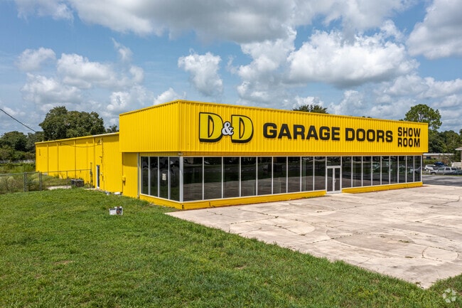
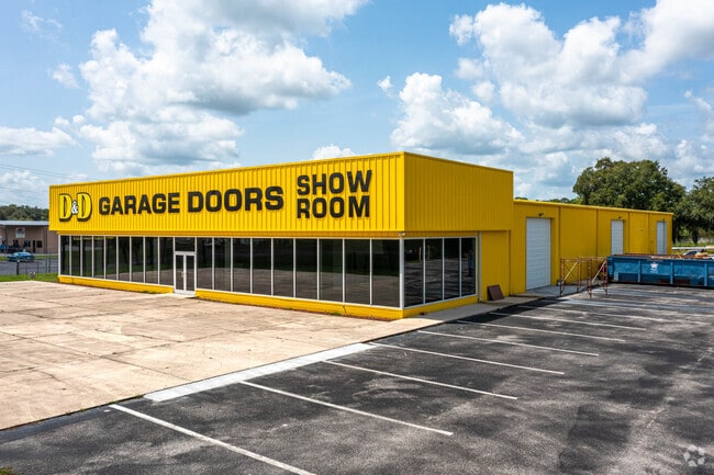
Property Record
8134 Us Highway 98 N, Lakeland, FL 33809

NEARBY LISTINGS FOR SALE OR LEASE
-
-
View all Lakeland listings for sale on LoopNet.com
Property Detail
8134 Us Highway 98 N
23-27-11-000000-021110
Alameda Heights
Storebuilding
S 70 YDS OF N1/2 OF SE1/4 OF NE1/4 OF SE1/4 LESS W 261 FT & LESS R/W FOR US 98
X
Polk
12105C0163G
Florida
2024
1.61 AC
2025
Polk County
012128
Tampa/St Petersburg
12,150 SF
Lakeland-Winter Haven, FL
DEMOGRAPHICS near 8134 Us Highway 98 N
1 Mile
3 Mile
5 Mile
2024 Total Population
5,236
43,118
88,719
2029 Population
6,335
51,306
105,770
Pop Growth 2024-2029
+ 20.99%
+ 18.99%
+ 19.22%
Average Age
38
43
42
2024 Total Households
1,804
16,688
34,389
HH Growth 2024-2029
+ 20.90%
+ 18.97%
+ 19.17%
Median Household Inc
$57,098
$63,411
$61,419
Avg Household Size
2.80
2.50
2.50
2024 Avg HH Vehicles
2.00
2.00
2.00
Median Home Value
$245,627
$217,412
$214,873
Median Year Built
2001
1993
1993
Nearby Places
Map Layers
Map Styles
 Street
 Aerial
- Restaurants
- Banks
- Shops
- Fitness
- Groceries
PUBLIC TRANSPORTATION
COMMUTER RAIL
Lakeland (Silver Star - Amtrak)
DRIVE
WALK
Distance
Lakeland (Silver Star - Amtrak)
14 min
7.8 mi
Freight Ports
Port of Tampa Bay
DRIVE
WALK
Distance
Port of Tampa Bay
50 min
38.2 mi
SALE & LEASE HISTORY
LISTING DATE
SALE/LEASE

Nov 22, 2019
For Sale
Jan 27, 2020
For Sale
Aug 07, 2020
For Sale
Nearby Properties
Address
Land Use
TOTAL SIZE
Lot Size
Zoning
Address
Land Use
TOTAL SIZE
Lot Size
Zoning
361,669 SF
12.73 AC
Address
Land Use
TOTAL SIZE
Lot Size
Zoning
169,546 SF
14.40 AC
PUD
Address
Land Use
TOTAL SIZE
Lot Size
Zoning
142,936 SF
26.38 AC
Address
Land Use
TOTAL SIZE
Lot Size
Zoning
226,634 SF
27.21 AC
C3
Address
Land Use
TOTAL SIZE
Lot Size
Zoning
206,724 SF
66.04 AC
RC
Address
Land Use
TOTAL SIZE
Lot Size
Zoning
118,250 SF
23.12 AC
Address
Land Use
TOTAL SIZE
Lot Size
Zoning
129,358 SF
8.84 AC
Address
Land Use
TOTAL SIZE
Lot Size
Zoning
42,557 SF
26.12 AC
Address
Land Use
TOTAL SIZE
Lot Size
Zoning
86,578 SF
9.84 AC
C2
Address
Land Use
TOTAL SIZE
Lot Size
Zoning
101,160 SF
27.71 AC
RC
Address
Land Use
TOTAL SIZE
Lot Size
Zoning
57,481 SF
12.46 AC
RE1
Address
Land Use
TOTAL SIZE
Lot Size
Zoning
102,260 SF
6.78 AC
C3
Address
Land Use
TOTAL SIZE
Lot Size
Zoning
77,845 SF
9.44 AC
C3
Address
Land Use
TOTAL SIZE
Lot Size
Zoning
42,213 SF
26.89 AC
RC
Address
Land Use
TOTAL SIZE
Lot Size
Zoning
38,640 SF
3.95 AC
C3
Address
Land Use
TOTAL SIZE
Lot Size
Zoning
83,640 SF
13.55 AC
R2
Address
Land Use
TOTAL SIZE
Lot Size
Zoning
125,738 SF
18.74 AC
RC
Address
Land Use
TOTAL SIZE
Lot Size
Zoning
75,572 SF
12.51 AC
C3
Address
Land Use
TOTAL SIZE
Lot Size
Zoning
30,429 SF
5.95 AC
Address
Land Use
TOTAL SIZE
Lot Size
Zoning
54,796 SF
7.16 AC
PUD
Address
Land Use
TOTAL SIZE
Lot Size
Zoning
29,855 SF
5.35 AC
RC
Address
Land Use
TOTAL SIZE
Lot Size
Zoning
128,017 SF
80.37 AC
RC
Address
Land Use
TOTAL SIZE
Lot Size
Zoning
38,718 SF
9.18 AC
C3
Address
Land Use
TOTAL SIZE
Lot Size
Zoning
80,436 SF
5.39 AC
C3
Address
Land Use
TOTAL SIZE
Lot Size
Zoning
60,500 SF
4.07 AC
C3
Address
Land Use
TOTAL SIZE
Lot Size
Zoning
8,773 SF
1.57 AC
C3
Address
Land Use
TOTAL SIZE
Lot Size
Zoning
24,625 SF
10.34 AC
Address
Land Use
TOTAL SIZE
Lot Size
Zoning
29.81 AC
C3
Address
Land Use
TOTAL SIZE
Lot Size
Zoning
5,526 SF
3.25 AC
Address
Land Use
TOTAL SIZE
Lot Size
Zoning
11,200 SF
2.12 AC
C3
The World's #1 Commercial Real Estate Marketplace
Connect with us
© 2026 CoStar Group
The information above has been obtained from sources believed reliable. While we do not doubt its accuracy we have not verified it and make no guarantee, warranty or representation about it. It is your responsibility to independently confirm its accuracy and completeness. Any projections, opinions, assumptions, or estimates used are for example only and do not represent the current or future performance of the property. The value of this transaction to you depends on tax and other factors which should be evaluated by your tax, financial, and legal advisors. You and your advisors should conduct a careful, independent investigation of the property to determine to your satisfaction the suitability of the property for your needs.