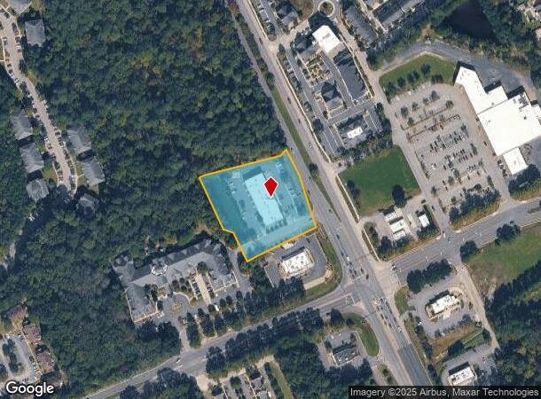
Property Record
8135 George Washington Mem Hwy, Yorktown, VA 23692

NEARBY LISTINGS FOR SALE OR LEASE
Property Detail
8135 George Washington Mem Hwy
Q08B-3677-4256
Memorial Highway Associates
Commercialnec
MEMORIAL HWY ASSOC LTD SUBDIV OF PARCEL 2 PARCEL 2B
X
York
51073C0280F
Virginia
2024
2.16 AC
2025
York
050306
Hampton Roads
12,565 SF
Virginia Beach-Norfolk-Newport News, VA-NC
DEMOGRAPHICS near 8135 George Washington Mem Hwy
1 Mile
3 Mile
5 Mile
2024 Total Population
4,963
20,879
81,267
2029 Population
5,194
21,422
81,883
Pop Growth 2024-2029
+ 4.65%
+ 2.60%
+ 0.76%
Average Age
45
41
38
2024 Total Households
2,050
8,139
32,305
HH Growth 2024-2029
+ 4.68%
+ 2.64%
+ 0.65%
Median Household Inc
$101,544
$90,445
$72,116
Avg Household Size
2.40
2.50
2.50
2024 Avg HH Vehicles
2.00
2.00
2.00
Median Home Value
$365,357
$299,434
$281,411
Median Year Built
1983
1986
1985
Nearby Places
Map Layers
Map Styles
 Street
 Aerial
- Restaurants
- Banks
- Shops
- Fitness
- Groceries
PUBLIC TRANSPORTATION
COMMUTER RAIL
Newport News (Northeast Regional - Amtrak)
DRIVE
WALK
Distance
Newport News (Northeast Regional - Amtrak)
11 min
8.3 mi
AIRPORT
Newport News/Williamsburg International
DRIVE
WALK
Distance
Newport News/Williamsburg International
11 min
5.8 mi
Norfolk International
DRIVE
WALK
Distance
Norfolk International
47 min
31.2 mi
Freight Ports
Virginia Port Authority - Newport News
DRIVE
WALK
Distance
Virginia Port Authority - Newport News
28 min
19.1 mi
Nearby Properties
Address
Land Use
TOTAL SIZE
Lot Size
Zoning
Address
Land Use
TOTAL SIZE
Lot Size
Zoning
255,746 SF
46.05 AC
P1
Address
Land Use
TOTAL SIZE
Lot Size
Zoning
297,617 SF
50.90 AC
RC,GB
Address
Land Use
TOTAL SIZE
Lot Size
Zoning
252 SF
17.21 AC
MULTI-FAMI
Address
Land Use
TOTAL SIZE
Lot Size
Zoning
5.04 AC
R9
Address
Land Use
TOTAL SIZE
Lot Size
Zoning
20,216 SF
141.21 AC
GENERAL IN
Address
Land Use
TOTAL SIZE
Lot Size
Zoning
290,802 SF
29.47 AC
RMF,GB
Address
Land Use
TOTAL SIZE
Lot Size
Zoning
156 SF
19.99 AC
MULTI-FAMI
Address
Land Use
TOTAL SIZE
Lot Size
Zoning
516,240 SF
658.11 AC
GENERAL IN
Address
Land Use
TOTAL SIZE
Lot Size
Zoning
1,669.43 AC
RESOURCE C
Address
Land Use
TOTAL SIZE
Lot Size
Zoning
152,753 SF
32.68 AC
RESOURCE C
Address
Land Use
TOTAL SIZE
Lot Size
Zoning
60,384 SF
15.90 AC
P1
Address
Land Use
TOTAL SIZE
Lot Size
Zoning
10,000 SF
9.10 AC
PLANNED DE
Address
Land Use
TOTAL SIZE
Lot Size
Zoning
83,316 SF
20 AC
P1
Address
Land Use
TOTAL SIZE
Lot Size
Zoning
56,654 SF
12.03 AC
LIMITED IN
Address
Land Use
TOTAL SIZE
Lot Size
Zoning
133,173 SF
27.21 AC
RESOURCE C
Address
Land Use
TOTAL SIZE
Lot Size
Zoning
37,012 SF
53.12 AC
LIMITED IN
Address
Land Use
TOTAL SIZE
Lot Size
Zoning
87,160 SF
19.68 AC
RESOURCE C
Address
Land Use
TOTAL SIZE
Lot Size
Zoning
39,411 SF
8.23 AC
GENERAL BU
Address
Land Use
TOTAL SIZE
Lot Size
Zoning
7,275 SF
18.02 AC
IL,GB
Address
Land Use
TOTAL SIZE
Lot Size
Zoning
261,151 SF
20.46 AC
M1
Address
Land Use
TOTAL SIZE
Lot Size
Zoning
73.35 AC
R9
Address
Land Use
TOTAL SIZE
Lot Size
Zoning
930.01 AC
RESOURCE C
Address
Land Use
TOTAL SIZE
Lot Size
Zoning
19,763 SF
2.98 AC
GENERAL BU
Address
Land Use
TOTAL SIZE
Lot Size
Zoning
66,266 SF
14 AC
RESOURCE C
Address
Land Use
TOTAL SIZE
Lot Size
Zoning
646.02 AC
RESOURCE C
Address
Land Use
TOTAL SIZE
Lot Size
Zoning
63,368 SF
17.22 AC
RESOURCE C
Address
Land Use
TOTAL SIZE
Lot Size
Zoning
69,573 SF
12.44 AC
GB,R20
Address
Land Use
TOTAL SIZE
Lot Size
Zoning
74,345 SF
8.53 AC
GENERAL BU
Address
Land Use
TOTAL SIZE
Lot Size
Zoning
40.06 AC
R9
The World's #1 Commercial Real Estate Marketplace
Connect with us
© 2025 CoStar Group
The information above has been obtained from sources believed reliable. While we do not doubt its accuracy we have not verified it and make no guarantee, warranty or representation about it. It is your responsibility to independently confirm its accuracy and completeness. Any projections, opinions, assumptions, or estimates used are for example only and do not represent the current or future performance of the property. The value of this transaction to you depends on tax and other factors which should be evaluated by your tax, financial, and legal advisors. You and your advisors should conduct a careful, independent investigation of the property to determine to your satisfaction the suitability of the property for your needs.