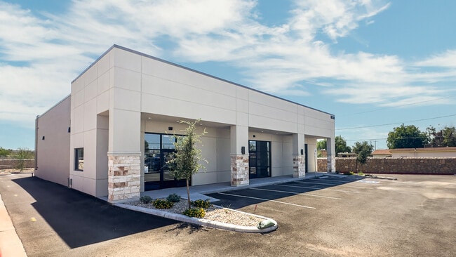
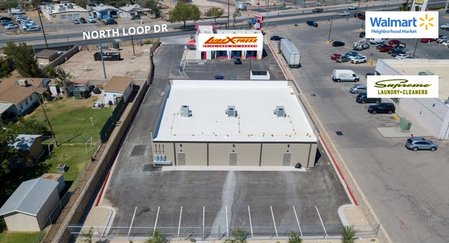
Property Record
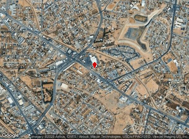
8135 N Loop Dr, El Paso, TX 79907
Current Lease Availabilities
NEARBY LISTINGS FOR SALE OR LEASE
Property Detail
8135 N Loop Dr
El Paso, TX
Lamb
L193-999-0010-0450
LAMB WLY PT OF TR 2 (79.05 ON NLY- IRREG ON ELY-106.19 ON SLY- 94.77 ON WLY) (7171.01 SQ FT)
Governmentalpublicusegeneral
El Paso
X
Texas
4802140045C
0.17 AC
0
East
2025
El Paso
004106
DEMOGRAPHICS near 8135 N Loop Dr
1 mile
3 mile
5 mile
2024 Total Population
15,653
93,348
219,270
2029 Population
15,907
93,763
219,154
Pop Growth 2024-2029
+ 1.62%
+ 0.44%
(0.05%)
Average Age
40
40
39
2024 Total Households
5,629
34,656
79,803
HH Growth 2024-2029
+ 1.56%
+ 0.49%
0.00%
Median Household Inc
$37,936
$38,611
$47,577
Avg Household Size
2.70
2.60
2.70
2024 Avg HH Vehicles
2.00
2.00
2.00
Median Home Value
$118,024
$128,395
$144,213
Median Year Built
1971
1975
1978
Nearby Places
Map Layers
Map Styles
 Street
 Aerial
Transit
 Traffic
 Biking
Places
Listings with unknown addresses are not visible on the map
- Restaurants
- Banks
- Shops
- Fitness
- Groceries
PUBLIC TRANSPORTATION
AIRPORT
El Paso International
Drive
Walk
Distance
El Paso International
20 min
9.3 mi
Freight Ports
Port of Corpus Christi
Drive
Walk
Distance
Port of Corpus Christi
672 min
686.3 mi
Nearby Properties
Address
Land Use
TOTAL SIZE
Lot Size
Zoning
Address
Land Use
TOTAL SIZE
Lot Size
Zoning
600,211 SF
114.73 AC
RF
Address
Land Use
TOTAL SIZE
Lot Size
Zoning
1 SF
M1
Address
Land Use
TOTAL SIZE
Lot Size
Zoning
1 SF
Address
Land Use
TOTAL SIZE
Lot Size
Zoning
377,168 SF
8.40 AC
C1
Address
Land Use
TOTAL SIZE
Lot Size
Zoning
80,049 SF
8.90 AC
C4
Address
Land Use
TOTAL SIZE
Lot Size
Zoning
235,670 SF
10 AC
A3C
Address
Land Use
TOTAL SIZE
Lot Size
Zoning
118,114 SF
13.80 AC
C4S
Address
Land Use
TOTAL SIZE
Lot Size
Zoning
202,253 SF
10.70 AC
A2
Address
Land Use
TOTAL SIZE
Lot Size
Zoning
166,671 SF
24.61 AC
C4S
Address
Land Use
TOTAL SIZE
Lot Size
Zoning
125,896 SF
8.67 AC
R3
Address
Land Use
TOTAL SIZE
Lot Size
Zoning
209,006 SF
18.18 AC
C4
Address
Land Use
TOTAL SIZE
Lot Size
Zoning
192,261 SF
8.07 AC
A3C
Address
Land Use
TOTAL SIZE
Lot Size
Zoning
206,726 SF
24.42 AC
M1S
Address
Land Use
TOTAL SIZE
Lot Size
Zoning
347,235 SF
33.50 AC
A2
Address
Land Use
TOTAL SIZE
Lot Size
Zoning
111,558 SF
16.25 AC
C4
Address
Land Use
TOTAL SIZE
Lot Size
Zoning
259,968 SF
10.54 AC
AO
Address
Land Use
TOTAL SIZE
Lot Size
Zoning
269,974 SF
15.87 AC
A2S
Address
Land Use
TOTAL SIZE
Lot Size
Zoning
63,058 SF
21.40 AC
C4
Address
Land Use
TOTAL SIZE
Lot Size
Zoning
109,578 SF
17.84 AC
RF
Address
Land Use
TOTAL SIZE
Lot Size
Zoning
144,211 SF
17.20 AC
C4
Address
Land Use
TOTAL SIZE
Lot Size
Zoning
341,541 SF
22.51 AC
A2
Address
Land Use
TOTAL SIZE
Lot Size
Zoning
226,736 SF
12 AC
A2
Address
Land Use
TOTAL SIZE
Lot Size
Zoning
307,575 SF
37.26 AC
Address
Land Use
TOTAL SIZE
Lot Size
Zoning
92,263 SF
14.37 AC
C4
Address
Land Use
TOTAL SIZE
Lot Size
Zoning
139,470 SF
11.33 AC
C3
Address
Land Use
TOTAL SIZE
Lot Size
Zoning
147,393 SF
11.28 AC
C4
Address
Land Use
TOTAL SIZE
Lot Size
Zoning
153,159 SF
11.86 AC
C1
Address
Land Use
TOTAL SIZE
Lot Size
Zoning
136,526 SF
10.97 AC
C3
Address
Land Use
TOTAL SIZE
Lot Size
Zoning
207,661 SF
11.21 AC
A2
Address
Land Use
TOTAL SIZE
Lot Size
Zoning
132,336 SF
12.12 AC
A2
The World's #1 Commercial Real Estate Marketplace
Connect with us
© 2026 CoStar Group
The information above has been obtained from sources believed reliable. While we do not doubt its accuracy we have not verified it and make no guarantee, warranty or representation about it. It is your responsibility to independently confirm its accuracy and completeness. Any projections, opinions, assumptions, or estimates used are for example only and do not represent the current or future performance of the property. The value of this transaction to you depends on tax and other factors which should be evaluated by your tax, financial, and legal advisors. You and your advisors should conduct a careful, independent investigation of the property to determine to your satisfaction the suitability of the property for your needs.