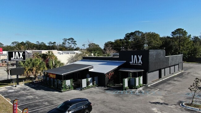
Property Record
8136 Atlantic Blvd, Jacksonville, FL 32211

Save to a Folder
{{folder.Name}}
{{folder.ListingIds.length}} Properties
{{folder.ListingIds.length}} Property
Create a New Folder
This Property Is For Sale
Property Detail
8136 Atlantic Blvd
145117-0020
9-25 52-2S-27E .86 WARRINGTON R/P PT BLK 45 OAKWOOD VILLAS PT LOTS 5,6 RECD O/R 18803-2274 BLK 40
Restaurantbuilding
Duval
CCG-2
Florida
B and X Area of moderate flood hazard, usually the area between the limits of the 100-year and 500-year floods.
5,6
2025
0.85 AC
2026
Southside
015805
Jacksonville (Florida)
6,833 SF
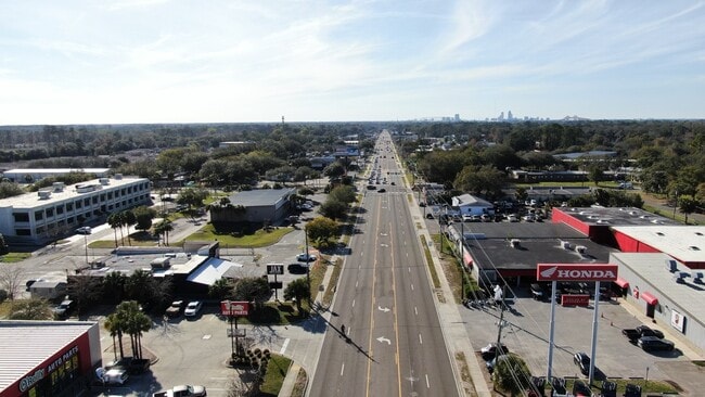
Jacksonville, FL
NEARBY LISTINGS FOR SALE OR LEASE
DEMOGRAPHICS near 8136 Atlantic Blvd
1 mile
3 mile
5 mile
2025 Total Population
16,637
95,190
225,808
2030 Population
17,676
100,825
239,095
Pop Growth 2025-2030
+ 6.25%
+ 5.92%
+ 5.88%
Average Age
35
38
38
2025 Total Households
6,774
38,613
91,779
HH Growth 2025-2030
+ 6.50%
+ 6.21%
+ 6.22%
Median Household Inc
$52,734
$55,727
$62,786
Avg Household Size
2.40
2.40
2.30
2025 Avg HH Vehicles
1.00
2.00
2.00
Median Home Value
$232,075
$254,145
$274,628
Median Year Built
1982
1974
1982
Nearby Places
Map Layers
Map Styles
 Street
 Aerial
Layers
 Traffic
 Biking
Places
Listings with unknown addresses are not visible on the map
- Restaurants
- Banks
- Shops
- Fitness
- Groceries
PUBLIC TRANSPORTATION
AIRPORT
Jacksonville International
Drive
Walk
Distance
Jacksonville International
28 min
18.7 mi
Nearby Properties
Address
Land Use
TOTAL SIZE
Lot Size
Zoning
Address
Land Use
TOTAL SIZE
Lot Size
Zoning
875,866 SF
22.33 AC
PBF-3
Address
Land Use
TOTAL SIZE
Lot Size
Zoning
565,202 SF
33.92 AC
RMD-D
Address
Land Use
TOTAL SIZE
Lot Size
Zoning
327,165 SF
25 AC
RMD-D
Address
Land Use
TOTAL SIZE
Lot Size
Zoning
557,032 SF
40.06 AC
PUD
Address
Land Use
TOTAL SIZE
Lot Size
Zoning
308,517 SF
19.55 AC
PUD
Address
Land Use
TOTAL SIZE
Lot Size
Zoning
430,668 SF
27.20 AC
RMD-D
Address
Land Use
TOTAL SIZE
Lot Size
Zoning
323,318 SF
19.24 AC
PUD
Address
Land Use
TOTAL SIZE
Lot Size
Zoning
321,335 SF
19.83 AC
RMD-D
Address
Land Use
TOTAL SIZE
Lot Size
Zoning
410,225 SF
22.11 AC
PUD
Address
Land Use
TOTAL SIZE
Lot Size
Zoning
93,059 SF
8.54 AC
CCG-2
Address
Land Use
TOTAL SIZE
Lot Size
Zoning
302,406 SF
20.54 AC
RMD-D
Address
Land Use
TOTAL SIZE
Lot Size
Zoning
300,360 SF
14.44 AC
RMD-C
Address
Land Use
TOTAL SIZE
Lot Size
Zoning
232,520 SF
12.37 AC
RMD-D
Address
Land Use
TOTAL SIZE
Lot Size
Zoning
184,221 SF
12.05 AC
PUD
Address
Land Use
TOTAL SIZE
Lot Size
Zoning
210,913 SF
10.32 AC
PUD
Address
Land Use
TOTAL SIZE
Lot Size
Zoning
210,829 SF
11.84 AC
RMD-D
Address
Land Use
TOTAL SIZE
Lot Size
Zoning
275,005 SF
28.48 AC
PUD
Address
Land Use
TOTAL SIZE
Lot Size
Zoning
225,282 SF
15.36 AC
RMD-D
Address
Land Use
TOTAL SIZE
Lot Size
Zoning
172,591 SF
8.40 AC
CRO
Address
Land Use
TOTAL SIZE
Lot Size
Zoning
164,330 SF
9.04 AC
PUD
Address
Land Use
TOTAL SIZE
Lot Size
Zoning
150,073 SF
11.23 AC
CCG-1
Address
Land Use
TOTAL SIZE
Lot Size
Zoning
125,088 SF
6.62 AC
RMD-D
Address
Land Use
TOTAL SIZE
Lot Size
Zoning
245,531 SF
17.37 AC
CCG-1
Address
Land Use
TOTAL SIZE
Lot Size
Zoning
182,393 SF
8.60 AC
RMD-D
Address
Land Use
TOTAL SIZE
Lot Size
Zoning
60,464 SF
8.13 AC
CCG-2
Address
Land Use
TOTAL SIZE
Lot Size
Zoning
279,857 SF
12.71 AC
RMD-D
Address
Land Use
TOTAL SIZE
Lot Size
Zoning
180,180 SF
11.06 AC
CRO
Address
Land Use
TOTAL SIZE
Lot Size
Zoning
115,628 SF
6.26 AC
CRO
Address
Land Use
TOTAL SIZE
Lot Size
Zoning
116,814 SF
11.77 AC
RMD-D
Address
Land Use
TOTAL SIZE
Lot Size
Zoning
211,429 SF
18.27 AC
PUD
The World's #1 Commercial Real Estate Marketplace
Connect with us
© 2026 CoStar Group
The information above has been obtained from sources believed reliable. While we do not doubt its accuracy we have not verified it and make no guarantee, warranty or representation about it. It is your responsibility to independently confirm its accuracy and completeness. Any projections, opinions, assumptions, or estimates used are for example only and do not represent the current or future performance of the property. The value of this transaction to you depends on tax and other factors which should be evaluated by your tax, financial, and legal advisors. You and your advisors should conduct a careful, independent investigation of the property to determine to your satisfaction the suitability of the property for your needs.