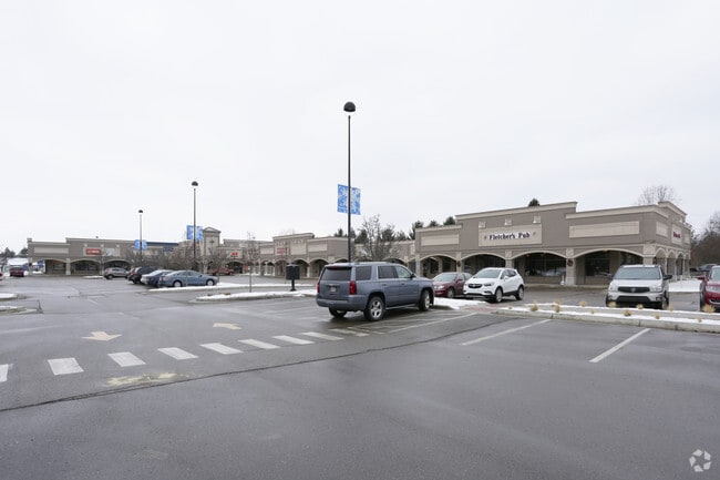
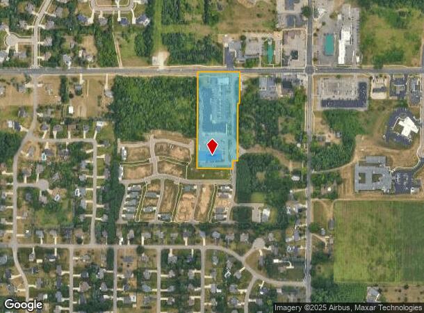
Property Record
8136 Shooting Star Ln, Kalamazoo, MI 49009
NEARBY LISTINGS FOR SALE OR LEASE
Property Detail
8136 Shooting Star Ln
Kalamazoo-Portage, MI
SEC 22-3-12 BEG ON N LI 1987.54 FT S 89DEG-15?-50? E OF N 1/4 POST TH CONT S 89DEG-15?-50? E ALG N LI 66 FT TH S
09-22-226-003
Kalamazoo
Commercialnec
Michigan
2025
2.39 AC
2025
Southern Kalamazoo County
003006
West Michigan
DEMOGRAPHICS near 8136 Shooting Star Ln
1 Mile
3 Mile
5 Mile
2024 Total Population
2,946
16,761
53,053
2029 Population
2,946
16,684
52,800
Pop Growth 2024-2029
0.00%
(0.46%)
(0.48%)
Average Age
38
39
39
2024 Total Households
1,016
5,980
20,908
HH Growth 2024-2029
(0.10%)
(0.54%)
(0.54%)
Median Household Inc
$134,853
$126,250
$88,824
Avg Household Size
2.90
2.80
2.50
2024 Avg HH Vehicles
2.00
2.00
2.00
Median Home Value
$341,059
$338,814
$269,066
Median Year Built
2000
1994
1987
Nearby Places
Map Layers
Map Styles
 Street
 Aerial
- Restaurants
- Banks
- Shops
- Fitness
- Groceries
PUBLIC TRANSPORTATION
AIRPORT
Kalamazoo/Battle Creek International
DRIVE
WALK
Distance
Kalamazoo/Battle Creek International
22 min
10.7 mi
Freight Ports
Port of Toledo
DRIVE
WALK
Distance
Port of Toledo
186 min
152.2 mi
Nearby Properties
Address
Land Use
TOTAL SIZE
Lot Size
Zoning
Address
Land Use
TOTAL SIZE
Lot Size
Zoning
424,967 SF
55.60 AC
I-1
Address
Land Use
TOTAL SIZE
Lot Size
Zoning
140,000 SF
22.69 AC
EBT
Address
Land Use
TOTAL SIZE
Lot Size
Zoning
16.75 AC
CBD
Address
Land Use
TOTAL SIZE
Lot Size
Zoning
4.33 AC
C-1
Address
Land Use
TOTAL SIZE
Lot Size
Zoning
6,874 SF
163.50 AC
PD
Address
Land Use
TOTAL SIZE
Lot Size
Zoning
8.83 AC
I-1
Address
Land Use
TOTAL SIZE
Lot Size
Zoning
92,694 SF
16.10 AC
EBT
Address
Land Use
TOTAL SIZE
Lot Size
Zoning
50.10 AC
C-3
Address
Land Use
TOTAL SIZE
Lot Size
Zoning
7.18 AC
CBD
Address
Land Use
TOTAL SIZE
Lot Size
Zoning
8.92 AC
PD
Address
Land Use
TOTAL SIZE
Lot Size
Zoning
226,877 SF
20.48 AC
I-1
Address
Land Use
TOTAL SIZE
Lot Size
Zoning
7.57 AC
Address
Land Use
TOTAL SIZE
Lot Size
Zoning
44,038 SF
6.50 AC
CBD CORNER
Address
Land Use
TOTAL SIZE
Lot Size
Zoning
1,489 SF
7.79 AC
R-1T
Address
Land Use
TOTAL SIZE
Lot Size
Zoning
14.38 AC
I-1
Address
Land Use
TOTAL SIZE
Lot Size
Zoning
80,550 SF
11.02 AC
R-5
Address
Land Use
TOTAL SIZE
Lot Size
Zoning
192,081 SF
27.50 AC
EBT
Address
Land Use
TOTAL SIZE
Lot Size
Zoning
99,400 SF
7.39 AC
I-1
Address
Land Use
TOTAL SIZE
Lot Size
Zoning
38.51 AC
R-6
Address
Land Use
TOTAL SIZE
Lot Size
Zoning
45,322 SF
3.75 AC
C-1
Address
Land Use
TOTAL SIZE
Lot Size
Zoning
21,940 SF
8.30 AC
OS-1
Address
Land Use
TOTAL SIZE
Lot Size
Zoning
20,600 SF
3.12 AC
PD
Address
Land Use
TOTAL SIZE
Lot Size
Zoning
14,518 SF
2.94 AC
CBD CORNER
Address
Land Use
TOTAL SIZE
Lot Size
Zoning
15,883 SF
2.99 AC
PD
Address
Land Use
TOTAL SIZE
Lot Size
Zoning
29,709 SF
1.73 AC
C-4
Address
Land Use
TOTAL SIZE
Lot Size
Zoning
27,390 SF
5.34 AC
R-1T
Address
Land Use
TOTAL SIZE
Lot Size
Zoning
73,599 SF
14.98 AC
I-1
Address
Land Use
TOTAL SIZE
Lot Size
Zoning
26.16 AC
R-6
Address
Land Use
TOTAL SIZE
Lot Size
Zoning
9,000 SF
5.25 AC
PD
Address
Land Use
TOTAL SIZE
Lot Size
Zoning
30,424 SF
1.62 AC
C-4
The World's #1 Commercial Real Estate Marketplace
Connect with us
© 2026 CoStar Group
The information above has been obtained from sources believed reliable. While we do not doubt its accuracy we have not verified it and make no guarantee, warranty or representation about it. It is your responsibility to independently confirm its accuracy and completeness. Any projections, opinions, assumptions, or estimates used are for example only and do not represent the current or future performance of the property. The value of this transaction to you depends on tax and other factors which should be evaluated by your tax, financial, and legal advisors. You and your advisors should conduct a careful, independent investigation of the property to determine to your satisfaction the suitability of the property for your needs.