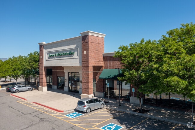
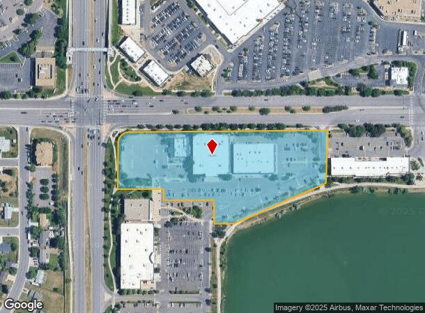
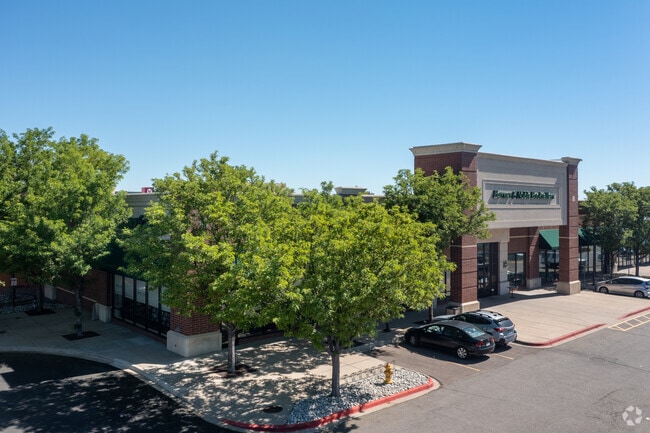
Property Record
8136 W Bowles Ave, Littleton, CO 80123
NEARBY LISTINGS FOR SALE OR LEASE
Property Detail
8136 W Bowles Ave
Denver-Aurora-Centennial, CO
Chanson Plaza & Amd #1
59-232-03-015
SECTION 23 TOWNSHIP 05 RANGE 69 QTR NW SUBDIVISIONCD 120100 SUBDIVISIONNAME CHANSON PLAZA & AMD #1 BLOCK LOT 0003 SIZE: 257440 TRACT VALUE: 5.910
Commercialnec
Jefferson
AE
Colorado
0800460252H
3
2023
5.91 AC
2024
Southwest
012048
Denver
56,352 SF
DEMOGRAPHICS near 8136 W Bowles Ave
1 Mile
3 Mile
5 Mile
2024 Total Population
11,094
102,801
218,491
2029 Population
11,008
101,646
217,207
Pop Growth 2024-2029
(0.78%)
(1.12%)
(0.59%)
Average Age
43
42
42
2024 Total Households
4,542
39,665
88,127
HH Growth 2024-2029
(0.95%)
(1.14%)
(0.53%)
Median Household Inc
$102,235
$107,963
$97,070
Avg Household Size
2.40
2.50
2.40
2024 Avg HH Vehicles
2.00
2.00
2.00
Median Home Value
$497,106
$567,435
$549,402
Median Year Built
1990
1985
1983
Nearby Places
Map Layers
Map Styles
 Street
 Aerial
- Restaurants
- Banks
- Shops
- Fitness
- Groceries
PUBLIC TRANSPORTATION
AIRPORT
Denver International
DRIVE
WALK
Distance
Denver International
51 min
36.6 mi
Freight Ports
Tulsa Port Of Catoosa
DRIVE
WALK
Distance
Tulsa Port Of Catoosa
747 min
719.4 mi
Nearby Properties
Address
Land Use
TOTAL SIZE
Lot Size
Zoning
Address
Land Use
TOTAL SIZE
Lot Size
Zoning
665,722 SF
615.85 AC
OS-B
Address
Land Use
TOTAL SIZE
Lot Size
Zoning
272,246 SF
31.76 AC
PD
Address
Land Use
TOTAL SIZE
Lot Size
Zoning
381,135 SF
35.02 AC
Address
Land Use
TOTAL SIZE
Lot Size
Zoning
298,752 SF
73.96 AC
Address
Land Use
TOTAL SIZE
Lot Size
Zoning
600,847 SF
32.41 AC
PD
Address
Land Use
TOTAL SIZE
Lot Size
Zoning
600,847 SF
35.87 AC
PD
Address
Land Use
TOTAL SIZE
Lot Size
Zoning
452,193 SF
12.56 AC
Address
Land Use
TOTAL SIZE
Lot Size
Zoning
391,595 SF
27.94 AC
Address
Land Use
TOTAL SIZE
Lot Size
Zoning
446,582 SF
19.24 AC
Address
Land Use
TOTAL SIZE
Lot Size
Zoning
178,421 SF
12.31 AC
PD
Address
Land Use
TOTAL SIZE
Lot Size
Zoning
293,292 SF
13.78 AC
S-CC
Address
Land Use
TOTAL SIZE
Lot Size
Zoning
63,347 SF
20.70 AC
Address
Land Use
TOTAL SIZE
Lot Size
Zoning
304,475 SF
22.32 AC
Address
Land Use
TOTAL SIZE
Lot Size
Zoning
123,843 SF
6.03 AC
Address
Land Use
TOTAL SIZE
Lot Size
Zoning
329,538 SF
14.64 AC
B-4
Address
Land Use
TOTAL SIZE
Lot Size
Zoning
296,034 SF
14.26 AC
R-2-A
Address
Land Use
TOTAL SIZE
Lot Size
Zoning
189,672 SF
16.74 AC
PD
Address
Land Use
TOTAL SIZE
Lot Size
Zoning
133,594 SF
25.03 AC
Address
Land Use
TOTAL SIZE
Lot Size
Zoning
224,595 SF
14.66 AC
Address
Land Use
TOTAL SIZE
Lot Size
Zoning
94,367 SF
10.02 AC
R-2
Address
Land Use
TOTAL SIZE
Lot Size
Zoning
85,580 SF
12.54 AC
Address
Land Use
TOTAL SIZE
Lot Size
Zoning
151,602 SF
38.93 AC
Address
Land Use
TOTAL SIZE
Lot Size
Zoning
221,819 SF
33.64 AC
A1
Address
Land Use
TOTAL SIZE
Lot Size
Zoning
183,858 SF
9.30 AC
PUD
Address
Land Use
TOTAL SIZE
Lot Size
Zoning
101,795 SF
12.61 AC
PD
Address
Land Use
TOTAL SIZE
Lot Size
Zoning
105,093 SF
9.32 AC
B-2
Address
Land Use
TOTAL SIZE
Lot Size
Zoning
279,023 SF
13.15 AC
LPD-R
Address
Land Use
TOTAL SIZE
Lot Size
Zoning
297,003 SF
26.77 AC
PD
Address
Land Use
TOTAL SIZE
Lot Size
Zoning
221,123 SF
14.82 AC
PD
Address
Land Use
TOTAL SIZE
Lot Size
Zoning
52,493 SF
12.69 AC
The World's #1 Commercial Real Estate Marketplace
Connect with us
© 2026 CoStar Group
The information above has been obtained from sources believed reliable. While we do not doubt its accuracy we have not verified it and make no guarantee, warranty or representation about it. It is your responsibility to independently confirm its accuracy and completeness. Any projections, opinions, assumptions, or estimates used are for example only and do not represent the current or future performance of the property. The value of this transaction to you depends on tax and other factors which should be evaluated by your tax, financial, and legal advisors. You and your advisors should conduct a careful, independent investigation of the property to determine to your satisfaction the suitability of the property for your needs.