Property Record
814 6Th St, Clarkston, WA 99403
NEARBY LISTINGS FOR SALE OR LEASE
-
-
View all Clarkston listings for sale on LoopNet.com
Property Detail
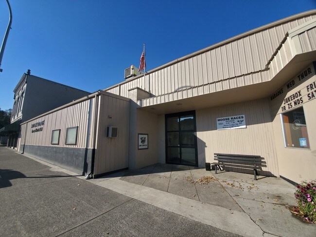
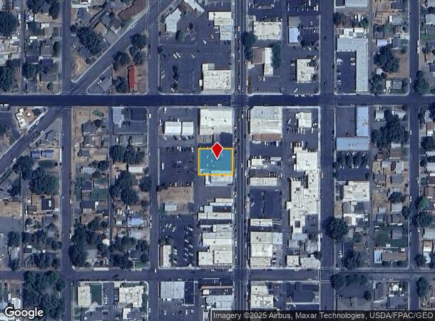
814 6Th St
Coeur D'Alene
Clarkston
Lewiston, ID-WA
CLARKSTON LOTS 13 14 15 & 16 BLK 9 COMM.BLDG YB 1950 SQ 11,737 B 7760
1-001-09-016-0000-0000
Asotin
Restaurantbuilding
Washington
2024
13
2025
0.29 AC
960300
Asotin
19,497 SF
DEMOGRAPHICS near 814 6Th St
1 Mile
3 Mile
5 Mile
2024 Total Population
11,066
36,735
51,026
2029 Population
11,503
38,356
53,382
Pop Growth 2024-2029
+ 3.95%
+ 4.41%
+ 4.62%
Average Age
40
41
42
2024 Total Households
4,712
15,293
21,413
HH Growth 2024-2029
+ 3.95%
+ 4.39%
+ 4.64%
Median Household Inc
$45,941
$58,281
$60,665
Avg Household Size
2.20
2.30
2.30
2024 Avg HH Vehicles
2.00
2.00
2.00
Median Home Value
$196,730
$259,169
$267,149
Median Year Built
1955
1968
1972
Nearby Places
Map Layers
Map Styles
 Street
 Aerial
- Restaurants
- Banks
- Shops
- Fitness
- Groceries
PUBLIC TRANSPORTATION
AIRPORT
Lewiston/Nez Perce County
DRIVE
WALK
Distance
Lewiston/Nez Perce County
15 min
6.0 mi
Pullman/Moscow Regional
DRIVE
WALK
Distance
Pullman/Moscow Regional
59 min
40.0 mi
Freight Ports
Port of Tacoma
DRIVE
WALK
Distance
Port of Tacoma
419 min
320.3 mi
SALE & LEASE HISTORY
LISTING DATE
SALE/LEASE

Oct 21, 2019
For Sale
Jun 15, 2021
For Sale
Nearby Properties
Address
Land Use
TOTAL SIZE
Lot Size
Zoning
Address
Land Use
TOTAL SIZE
Lot Size
Zoning
0.48 AC
Address
Land Use
TOTAL SIZE
Lot Size
Zoning
18.85 AC
11
Address
Land Use
TOTAL SIZE
Lot Size
Zoning
22.44 AC
1
Address
Land Use
TOTAL SIZE
Lot Size
Zoning
160,676 SF
8.24 AC
1
Address
Land Use
TOTAL SIZE
Lot Size
Zoning
25,810 SF
2.21 AC
Address
Land Use
TOTAL SIZE
Lot Size
Zoning
2.24 AC
Address
Land Use
TOTAL SIZE
Lot Size
Zoning
6.83 AC
Address
Land Use
TOTAL SIZE
Lot Size
Zoning
2.44 AC
Address
Land Use
TOTAL SIZE
Lot Size
Zoning
41,940 SF
1.68 AC
Address
Land Use
TOTAL SIZE
Lot Size
Zoning
52,577 SF
3.76 AC
Address
Land Use
TOTAL SIZE
Lot Size
Zoning
59,815 SF
9.36 AC
1
Address
Land Use
TOTAL SIZE
Lot Size
Zoning
1.60 AC
Address
Land Use
TOTAL SIZE
Lot Size
Zoning
16,126 SF
2.88 AC
Address
Land Use
TOTAL SIZE
Lot Size
Zoning
22,660 SF
7.43 AC
Address
Land Use
TOTAL SIZE
Lot Size
Zoning
22,264 SF
0.50 AC
Address
Land Use
TOTAL SIZE
Lot Size
Zoning
1.35 AC
Address
Land Use
TOTAL SIZE
Lot Size
Zoning
30,002 SF
1.51 AC
Address
Land Use
TOTAL SIZE
Lot Size
Zoning
11,574 SF
1.66 AC
Address
Land Use
TOTAL SIZE
Lot Size
Zoning
42,579 SF
5.74 AC
Address
Land Use
TOTAL SIZE
Lot Size
Zoning
1,647 SF
2.48 AC
Address
Land Use
TOTAL SIZE
Lot Size
Zoning
77,376 SF
2.67 AC
Address
Land Use
TOTAL SIZE
Lot Size
Zoning
1,802 SF
2.18 AC
1
Address
Land Use
TOTAL SIZE
Lot Size
Zoning
29,092 SF
1.56 AC
Address
Land Use
TOTAL SIZE
Lot Size
Zoning
31,620 SF
0.16 AC
NHMU
Address
Land Use
TOTAL SIZE
Lot Size
Zoning
3.94 AC
1
Address
Land Use
TOTAL SIZE
Lot Size
Zoning
38,340 SF
2.67 AC
Address
Land Use
TOTAL SIZE
Lot Size
Zoning
45,476 SF
2.56 AC
Address
Land Use
TOTAL SIZE
Lot Size
Zoning
9,600 SF
0.60 AC
Address
Land Use
TOTAL SIZE
Lot Size
Zoning
Address
Land Use
TOTAL SIZE
Lot Size
Zoning
14,550 SF
1.27 AC
The World's #1 Commercial Real Estate Marketplace
Connect with us
© 2026 CoStar Group
The information above has been obtained from sources believed reliable. While we do not doubt its accuracy we have not verified it and make no guarantee, warranty or representation about it. It is your responsibility to independently confirm its accuracy and completeness. Any projections, opinions, assumptions, or estimates used are for example only and do not represent the current or future performance of the property. The value of this transaction to you depends on tax and other factors which should be evaluated by your tax, financial, and legal advisors. You and your advisors should conduct a careful, independent investigation of the property to determine to your satisfaction the suitability of the property for your needs.