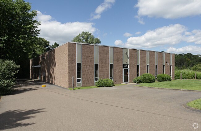
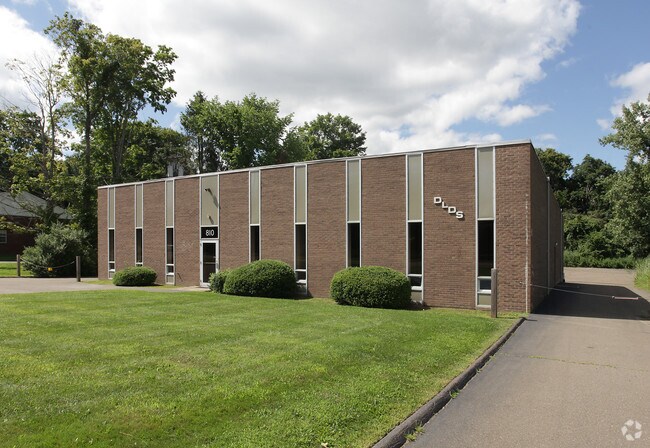
Property Record
814 E Main St, Branford, CT 06405

Property Detail
814 E Main St
BRAN-000003J-000001-000019
South Central Ct
Commercialbuilding
Connecticut
B and X Area of moderate flood hazard, usually the area between the limits of the 100-year and 500-year floods.
19
2025
3.10 AC
2025
Branford
184700
Westchester/So Connecticut
36,856 SF
New Haven, CT
NEARBY LISTINGS FOR SALE OR LEASE
DEMOGRAPHICS near 814 E Main St
1 mile
3 mile
5 mile
2025 Total Population
1,207
18,485
52,568
2030 Population
1,239
18,853
53,628
Pop Growth 2025-2030
+ 2.65%
+ 1.99%
+ 2.02%
Average Age
48
46
46
2025 Total Households
572
7,638
22,344
HH Growth 2025-2030
+ 2.62%
+ 1.95%
+ 1.98%
Median Household Inc
$95,535
$124,190
$110,090
Avg Household Size
2.00
2.40
2.30
2025 Avg HH Vehicles
2.00
2.00
2.00
Median Home Value
$385,655
$456,193
$461,069
Median Year Built
1979
1975
1973
Nearby Places
Map Layers
Map Styles
 Street
 Aerial
Layers
 Traffic
 Biking
Places
Listings with unknown addresses are not visible on the map
- Restaurants
- Banks
- Shops
- Fitness
- Groceries
PUBLIC TRANSPORTATION
COMMUTER RAIL
Branford (Shore Line East - Shore Line East)
Drive
Walk
Distance
Branford (Shore Line East - Shore Line East)
10 min
4.8 mi
Drive
Walk
Distance
10 min
5.4 mi
AIRPORT
Tweed/New Haven
Drive
Walk
Distance
Tweed/New Haven
18 min
9.5 mi
Freight Ports
Port of New Haven
Drive
Walk
Distance
Port of New Haven
15 min
9.2 mi
Nearby Properties
Address
Land Use
TOTAL SIZE
Lot Size
Zoning
Address
Land Use
TOTAL SIZE
Lot Size
Zoning
30 AC
R-5
Address
Land Use
TOTAL SIZE
Lot Size
Zoning
88.66 AC
I3
Address
Land Use
TOTAL SIZE
Lot Size
Zoning
175,913 SF
29 AC
Address
Land Use
TOTAL SIZE
Lot Size
Zoning
2,295.68 AC
R80
Address
Land Use
TOTAL SIZE
Lot Size
Zoning
7,065 SF
9.44 AC
Address
Land Use
TOTAL SIZE
Lot Size
Zoning
27.83 AC
SC
Address
Land Use
TOTAL SIZE
Lot Size
Zoning
10.30 AC
B1
Address
Land Use
TOTAL SIZE
Lot Size
Zoning
8.29 AC
Address
Land Use
TOTAL SIZE
Lot Size
Zoning
142,136 SF
58.31 AC
R-8
Address
Land Use
TOTAL SIZE
Lot Size
Zoning
79,294 SF
44 AC
R-5
Address
Land Use
TOTAL SIZE
Lot Size
Zoning
2,196 SF
1.68 AC
PRB3
Address
Land Use
TOTAL SIZE
Lot Size
Zoning
Address
Land Use
TOTAL SIZE
Lot Size
Zoning
13.90 AC
Address
Land Use
TOTAL SIZE
Lot Size
Zoning
54,799 SF
4.06 AC
Address
Land Use
TOTAL SIZE
Lot Size
Zoning
15.10 AC
Address
Land Use
TOTAL SIZE
Lot Size
Zoning
7.69 AC
RU1
Address
Land Use
TOTAL SIZE
Lot Size
Zoning
29.40 AC
Address
Land Use
TOTAL SIZE
Lot Size
Zoning
5,440 SF
12.44 AC
RGA
Address
Land Use
TOTAL SIZE
Lot Size
Zoning
49,215 SF
2.09 AC
Address
Land Use
TOTAL SIZE
Lot Size
Zoning
29.48 AC
I3
Address
Land Use
TOTAL SIZE
Lot Size
Zoning
695.83 AC
I1
Address
Land Use
TOTAL SIZE
Lot Size
Zoning
40,164 SF
11.50 AC
Address
Land Use
TOTAL SIZE
Lot Size
Zoning
45,766 SF
7.71 AC
R-7
Address
Land Use
TOTAL SIZE
Lot Size
Zoning
58,910 SF
5.17 AC
Address
Land Use
TOTAL SIZE
Lot Size
Zoning
38,352 SF
24 AC
Address
Land Use
TOTAL SIZE
Lot Size
Zoning
86,508 SF
7.07 AC
Address
Land Use
TOTAL SIZE
Lot Size
Zoning
58,601 SF
3.29 AC
Address
Land Use
TOTAL SIZE
Lot Size
Zoning
35,132 SF
2.89 AC
Address
Land Use
TOTAL SIZE
Lot Size
Zoning
The World's #1 Commercial Real Estate Marketplace
Connect with us
© 2026 CoStar Group
The information above has been obtained from sources believed reliable. While we do not doubt its accuracy we have not verified it and make no guarantee, warranty or representation about it. It is your responsibility to independently confirm its accuracy and completeness. Any projections, opinions, assumptions, or estimates used are for example only and do not represent the current or future performance of the property. The value of this transaction to you depends on tax and other factors which should be evaluated by your tax, financial, and legal advisors. You and your advisors should conduct a careful, independent investigation of the property to determine to your satisfaction the suitability of the property for your needs.