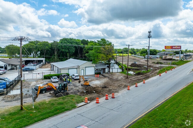
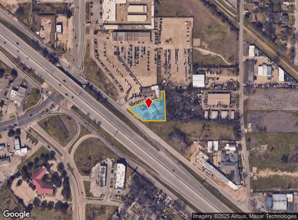
Property Record
8132 C F Hawn Fwy, Dallas, TX 75217

Current Lease Availabilities
NEARBY LISTINGS FOR SALE OR LEASE
Property Detail
8132 C F Hawn Fwy
00000573337000000
Hawn Fwy
Storebuilding
BLK 6362 TR 9 ACS 0.6412 INT201000334903 DD12272010 CO-DC 6362 000 00900 3DC6362 000
X
Dallas
48113C0510K
Texas
2024
0.64 AC
2025
East Dallas/Mesquite
011603
Dallas/Ft Worth
4,000 SF
Dallas-Fort Worth-Arlington, TX
DEMOGRAPHICS near 8132 C F Hawn Fwy
1 Mile
3 Mile
5 Mile
2024 Total Population
11,065
85,499
193,935
2029 Population
10,956
84,344
192,173
Pop Growth 2024-2029
(0.99%)
(1.35%)
(0.91%)
Average Age
33
34
34
2024 Total Households
3,036
23,231
55,268
HH Growth 2024-2029
(1.22%)
(1.62%)
(1.21%)
Median Household Inc
$39,203
$44,044
$44,145
Avg Household Size
3.50
3.50
3.30
2024 Avg HH Vehicles
2.00
2.00
2.00
Median Home Value
$125,494
$136,617
$148,688
Median Year Built
1962
1964
1972
Nearby Places
- Restaurants
- Banks
- Shops
- Fitness
- Groceries
PUBLIC TRANSPORTATION
TRANSIT/SUBWAY
Buckner Station (Green Line - Dallas Area Rapid Transit (DART))
DRIVE
WALK
Distance
Buckner Station (Green Line - Dallas Area Rapid Transit (DART))
2 min
10 min
0.5 mi
AIRPORT
Dallas Love Field
DRIVE
WALK
Distance
Dallas Love Field
24 min
14.7 mi
Dallas-Fort Worth International
DRIVE
WALK
Distance
Dallas-Fort Worth International
39 min
30.7 mi
Nearby Properties
Address
Land Use
TOTAL SIZE
Lot Size
Zoning
Address
Land Use
TOTAL SIZE
Lot Size
Zoning
199,246 SF
15.32 AC
Z250
Address
Land Use
TOTAL SIZE
Lot Size
Zoning
257,745 SF
31.54 AC
Z298
Address
Land Use
TOTAL SIZE
Lot Size
Zoning
117,218 SF
8.49 AC
Z298
Address
Land Use
TOTAL SIZE
Lot Size
Zoning
291,689 SF
11.21 AC
Z239
Address
Land Use
TOTAL SIZE
Lot Size
Zoning
95,000 SF
8.02 AC
Z298
Address
Land Use
TOTAL SIZE
Lot Size
Zoning
218,804 SF
13.79 AC
Z164
Address
Land Use
TOTAL SIZE
Lot Size
Zoning
141,566 SF
23 AC
Z298
Address
Land Use
TOTAL SIZE
Lot Size
Zoning
166,846 SF
6.78 AC
Z59
Address
Land Use
TOTAL SIZE
Lot Size
Zoning
91,000 SF
16.78 AC
Z239
Address
Land Use
TOTAL SIZE
Lot Size
Zoning
342,132 SF
18.04 AC
Z163
Address
Land Use
TOTAL SIZE
Lot Size
Zoning
123,499 SF
8.32 AC
Z239
Address
Land Use
TOTAL SIZE
Lot Size
Zoning
211,020 SF
17.46 AC
Z164
Address
Land Use
TOTAL SIZE
Lot Size
Zoning
667,344 SF
22.98 AC
Z115
Address
Land Use
TOTAL SIZE
Lot Size
Zoning
90,282 SF
9.94 AC
Z46
Address
Land Use
TOTAL SIZE
Lot Size
Zoning
143,713 SF
9.29 AC
Z59
Address
Land Use
TOTAL SIZE
Lot Size
Zoning
80,197 SF
4.85 AC
Z239
Address
Land Use
TOTAL SIZE
Lot Size
Zoning
199,780 SF
10.98 AC
Z163
Address
Land Use
TOTAL SIZE
Lot Size
Zoning
30,650 SF
0.02 AC
Z116
Address
Land Use
TOTAL SIZE
Lot Size
Zoning
42,034 SF
10.59 AC
Z151
Address
Land Use
TOTAL SIZE
Lot Size
Zoning
203 SF
23.94 AC
MFA
Address
Land Use
TOTAL SIZE
Lot Size
Zoning
183,303 SF
10.01 AC
Z164
Address
Land Use
TOTAL SIZE
Lot Size
Zoning
246,916 SF
19.12 AC
Z239
Address
Land Use
TOTAL SIZE
Lot Size
Zoning
129,554 SF
6.34 AC
Z59
Address
Land Use
TOTAL SIZE
Lot Size
Zoning
81,210 SF
12.91 AC
Z298
Address
Land Use
TOTAL SIZE
Lot Size
Zoning
183,094 SF
11.94 AC
Z164
Address
Land Use
TOTAL SIZE
Lot Size
Zoning
144,545 SF
7.50 AC
Z164
Address
Land Use
TOTAL SIZE
Lot Size
Zoning
131,208 SF
7.42 AC
Z164
Address
Land Use
TOTAL SIZE
Lot Size
Zoning
150,207 SF
9 AC
Z236
Address
Land Use
TOTAL SIZE
Lot Size
Zoning
189,132 SF
16.86 AC
Z239
Address
Land Use
TOTAL SIZE
Lot Size
Zoning
92,468 SF
10.87 AC
Z298
The World's #1 Commercial Real Estate Marketplace
Connect with us
© 2025 CoStar Group
The information above has been obtained from sources believed reliable. While we do not doubt its accuracy we have not verified it and make no guarantee, warranty or representation about it. It is your responsibility to independently confirm its accuracy and completeness. Any projections, opinions, assumptions, or estimates used are for example only and do not represent the current or future performance of the property. The value of this transaction to you depends on tax and other factors which should be evaluated by your tax, financial, and legal advisors. You and your advisors should conduct a careful, independent investigation of the property to determine to your satisfaction the suitability of the property for your needs.