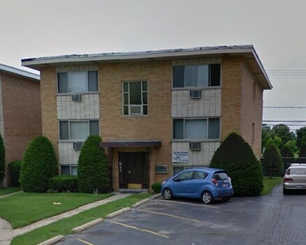
Property Record
8141 W Oconnor Dr, River Grove, IL 60171

NEARBY LISTINGS FOR SALE OR LEASE
-
-
No Photo
-
-
-
-
View all River Grove listings for sale on LoopNet.com
Property Detail
8141 W Oconnor Dr
Chicago-Naperville-Elgin, IL-IN-WI
River Grove Estates
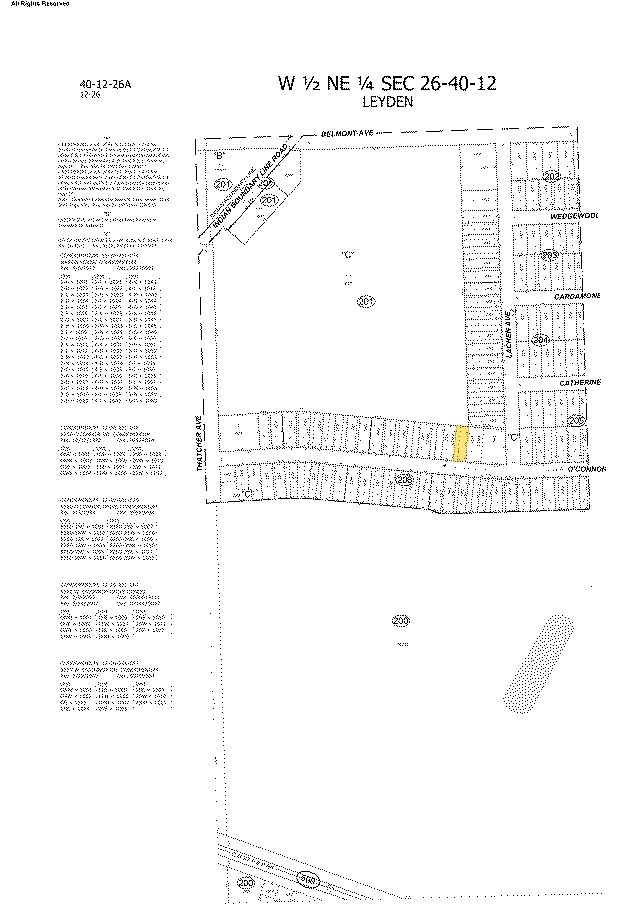
12-26-206-077-0000
(RIVER)(GROVE)(ESTATES) SUB IN NE SEC 26-40-12
Apartment
Cook
X
Illinois
17031C0387J
36,35
2023
0.12 AC
2024
River Grove
811100
Chicago
4,914 SF
DEMOGRAPHICS near 8141 W Oconnor Dr
1 Mile
3 Mile
5 Mile
2024 Total Population
27,139
212,401
594,064
2029 Population
26,226
203,800
566,231
Pop Growth 2024-2029
(3.36%)
(4.05%)
(4.69%)
Average Age
42
41
40
2024 Total Households
10,315
76,257
217,879
HH Growth 2024-2029
(3.72%)
(4.32%)
(4.90%)
Median Household Inc
$69,912
$72,493
$72,122
Avg Household Size
2.60
2.70
2.60
2024 Avg HH Vehicles
2.00
2.00
2.00
Median Home Value
$281,443
$289,380
$305,131
Median Year Built
1957
1956
1950
Nearby Places
Map Layers
Map Styles
 Street
 Aerial
- Restaurants
- Banks
- Shops
- Fitness
- Groceries
PUBLIC TRANSPORTATION
COMMUTER RAIL
River Grove Station (Milwaukee District West Line - Northeast Illinois Regional Commuter Railroad (Metra), North Central Service - Northeast Illinois Regional Commuter Railroad (Metra))
DRIVE
WALK
Distance
River Grove Station (Milwaukee District West Line - Northeast Illinois Regional Commuter Railroad (Metra), North Central Service - Northeast Illinois Regional Commuter Railroad (Metra))
2 min
11 min
0.6 mi
Elmwood Park Station (Milwaukee District West Line - Northeast Illinois Regional Commuter Railroad (Metra), North Central Service - Northeast Illinois Regional Commuter Railroad (Metra))
DRIVE
WALK
Distance
Elmwood Park Station (Milwaukee District West Line - Northeast Illinois Regional Commuter Railroad (Metra), North Central Service - Northeast Illinois Regional Commuter Railroad (Metra))
4 min
2.0 mi
AIRPORT
Chicago O'Hare International
DRIVE
WALK
Distance
Chicago O'Hare International
14 min
7.3 mi
Chicago Midway International
DRIVE
WALK
Distance
Chicago Midway International
27 min
15.3 mi
Freight Ports
Port Milwaukee
DRIVE
WALK
Distance
Port Milwaukee
98 min
80.5 mi
Nearby Properties
Address
Land Use
TOTAL SIZE
Lot Size
Zoning
Address
Land Use
TOTAL SIZE
Lot Size
Zoning
422,063 SF
18.88 AC
Address
Land Use
TOTAL SIZE
Lot Size
Zoning
192,365 SF
21.34 AC
PD 127
Address
Land Use
TOTAL SIZE
Lot Size
Zoning
396,650 SF
19.12 AC
Address
Land Use
TOTAL SIZE
Lot Size
Zoning
595,800 SF
9.40 AC
Address
Land Use
TOTAL SIZE
Lot Size
Zoning
9.90 AC
Address
Land Use
TOTAL SIZE
Lot Size
Zoning
Address
Land Use
TOTAL SIZE
Lot Size
Zoning
194,219 SF
17.26 AC
Address
Land Use
TOTAL SIZE
Lot Size
Zoning
548,206 SF
21.13 AC
Address
Land Use
TOTAL SIZE
Lot Size
Zoning
276,458 SF
16.14 AC
Address
Land Use
TOTAL SIZE
Lot Size
Zoning
Address
Land Use
TOTAL SIZE
Lot Size
Zoning
479,130 SF
15.80 AC
Address
Land Use
TOTAL SIZE
Lot Size
Zoning
13.33 AC
PD 127
Address
Land Use
TOTAL SIZE
Lot Size
Zoning
531,227 SF
18.32 AC
Address
Land Use
TOTAL SIZE
Lot Size
Zoning
348,133 SF
2.69 AC
Address
Land Use
TOTAL SIZE
Lot Size
Zoning
325,045 SF
13.79 AC
Address
Land Use
TOTAL SIZE
Lot Size
Zoning
277,819 SF
10.58 AC
PD 127
Address
Land Use
TOTAL SIZE
Lot Size
Zoning
897,723 SF
23.04 AC
PMD 15
Address
Land Use
TOTAL SIZE
Lot Size
Zoning
141,095 SF
9.15 AC
PD 127
Address
Land Use
TOTAL SIZE
Lot Size
Zoning
Address
Land Use
TOTAL SIZE
Lot Size
Zoning
152,533 SF
12.64 AC
Address
Land Use
TOTAL SIZE
Lot Size
Zoning
790,000 SF
31.71 AC
Address
Land Use
TOTAL SIZE
Lot Size
Zoning
Address
Land Use
TOTAL SIZE
Lot Size
Zoning
5.38 AC
Address
Land Use
TOTAL SIZE
Lot Size
Zoning
432,777 SF
22.29 AC
Address
Land Use
TOTAL SIZE
Lot Size
Zoning
15.48 AC
Address
Land Use
TOTAL SIZE
Lot Size
Zoning
126,955 SF
13.70 AC
PD 541
Address
Land Use
TOTAL SIZE
Lot Size
Zoning
318,305 SF
12.71 AC
Address
Land Use
TOTAL SIZE
Lot Size
Zoning
71,133 SF
7.28 AC
PD 441
Address
Land Use
TOTAL SIZE
Lot Size
Zoning
95,614 SF
4.20 AC
Address
Land Use
TOTAL SIZE
Lot Size
Zoning
65,243 SF
3.70 AC
The World's #1 Commercial Real Estate Marketplace
Connect with us
© 2025 CoStar Group
The information above has been obtained from sources believed reliable. While we do not doubt its accuracy we have not verified it and make no guarantee, warranty or representation about it. It is your responsibility to independently confirm its accuracy and completeness. Any projections, opinions, assumptions, or estimates used are for example only and do not represent the current or future performance of the property. The value of this transaction to you depends on tax and other factors which should be evaluated by your tax, financial, and legal advisors. You and your advisors should conduct a careful, independent investigation of the property to determine to your satisfaction the suitability of the property for your needs.