Property Record
8147 Cole Pky, Lenexa, KS 66227
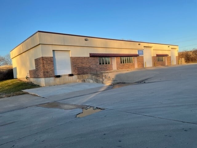


Property Detail
8147 Cole Pky
QP12500000-0T17
CERTIFICATE OF SURVEY OF PT S 1/2 NE1/4 28-12-23 AS REC INBK 1129 P 912 TR 17 EX S 100 & EX W 215.76 SHC 485 17
Warehouse
Johnson
PI
Kansas
B and X Area of moderate flood hazard, usually the area between the limits of the 100-year and 500-year floods.
0.53 AC
2024
Lenexa
2025
Kansas City
052604
Kansas City, MO-KS
6,000 SF
NEARBY LISTINGS FOR SALE OR LEASE
DEMOGRAPHICS near 8147 Cole Pky
1 mile
3 mile
5 mile
2025 Total Population
3,057
25,194
71,972
2030 Population
3,229
26,520
74,908
Pop Growth 2025-2030
+ 5.63%
+ 5.26%
+ 4.08%
Average Age
40
40
39
2025 Total Households
1,082
8,749
26,455
HH Growth 2025-2030
+ 5.73%
+ 5.42%
+ 4.18%
Median Household Inc
$132,291
$152,834
$138,387
Avg Household Size
2.80
2.80
2.70
2025 Avg HH Vehicles
2.00
2.00
2.00
Median Home Value
$442,192
$496,041
$473,734
Median Year Built
2007
2006
2004
Nearby Places
Map Layers
Map Styles
 Street
 Aerial
Layers
 Traffic
 Biking
Places
Listings with unknown addresses are not visible on the map
- Restaurants
- Banks
- Shops
- Fitness
- Groceries
PUBLIC TRANSPORTATION
AIRPORT
Kansas City International
Drive
Walk
Distance
Kansas City International
47 min
36.7 mi
SALE & LEASE HISTORY
LISTING DATE
SALE/LEASE

Dec 29, 2021
For Sale
Nearby Properties
Address
Land Use
TOTAL SIZE
Lot Size
Zoning
Address
Land Use
TOTAL SIZE
Lot Size
Zoning
39,668 SF
6.02 AC
Address
Land Use
TOTAL SIZE
Lot Size
Zoning
163,515 SF
70.39 AC
R1
Address
Land Use
TOTAL SIZE
Lot Size
Zoning
202,945 SF
30.29 AC
AG
Address
Land Use
TOTAL SIZE
Lot Size
Zoning
106,283 SF
11.79 AC
R1
Address
Land Use
TOTAL SIZE
Lot Size
Zoning
91,639 SF
19.51 AC
R1
Address
Land Use
TOTAL SIZE
Lot Size
Zoning
192,548 SF
20.09 AC
BP
Address
Land Use
TOTAL SIZE
Lot Size
Zoning
69,675 SF
11.85 AC
R1
Address
Land Use
TOTAL SIZE
Lot Size
Zoning
32,186 SF
2.80 AC
CH
Address
Land Use
TOTAL SIZE
Lot Size
Zoning
67,008 SF
26.85 AC
AG
Address
Land Use
TOTAL SIZE
Lot Size
Zoning
100,591 SF
33.88 AC
AG
Address
Land Use
TOTAL SIZE
Lot Size
Zoning
99,600 SF
7.77 AC
PI
Address
Land Use
TOTAL SIZE
Lot Size
Zoning
75,626 SF
17.48 AC
AG
Address
Land Use
TOTAL SIZE
Lot Size
Zoning
79,697 SF
11.36 AC
PSF
Address
Land Use
TOTAL SIZE
Lot Size
Zoning
74,420 SF
20.04 AC
AG
Address
Land Use
TOTAL SIZE
Lot Size
Zoning
73,003 SF
15.62 AC
R1
Address
Land Use
TOTAL SIZE
Lot Size
Zoning
30,751 SF
9.73 AC
R1
Address
Land Use
TOTAL SIZE
Lot Size
Zoning
52,710 SF
29.55 AC
AG
Address
Land Use
TOTAL SIZE
Lot Size
Zoning
24,208 SF
8.13 AC
CPO
Address
Land Use
TOTAL SIZE
Lot Size
Zoning
28,707 SF
11.92 AC
R1
Address
Land Use
TOTAL SIZE
Lot Size
Zoning
483,724 SF
50.52 AC
BP
Address
Land Use
TOTAL SIZE
Lot Size
Zoning
4.93 AC
CTY RUR
Address
Land Use
TOTAL SIZE
Lot Size
Zoning
32,412 SF
19.93 AC
BP
Address
Land Use
TOTAL SIZE
Lot Size
Zoning
13,500 SF
10.92 AC
R1
Address
Land Use
TOTAL SIZE
Lot Size
Zoning
24,478 SF
3.10 AC
R1
Address
Land Use
TOTAL SIZE
Lot Size
Zoning
20,832 SF
19.85 AC
AG
Address
Land Use
TOTAL SIZE
Lot Size
Zoning
40,568 SF
9.85 AC
AG
Address
Land Use
TOTAL SIZE
Lot Size
Zoning
12,746 SF
8.99 AC
AG
Address
Land Use
TOTAL SIZE
Lot Size
Zoning
16,078 SF
19.48 AC
PUDMR
Address
Land Use
TOTAL SIZE
Lot Size
Zoning
19,003 SF
4.47 AC
CH
Address
Land Use
TOTAL SIZE
Lot Size
Zoning
600 SF
91.25 AC
RUR
The World's #1 Commercial Real Estate Marketplace
Connect with us
© 2026 CoStar Group
The information above has been obtained from sources believed reliable. While we do not doubt its accuracy we have not verified it and make no guarantee, warranty or representation about it. It is your responsibility to independently confirm its accuracy and completeness. Any projections, opinions, assumptions, or estimates used are for example only and do not represent the current or future performance of the property. The value of this transaction to you depends on tax and other factors which should be evaluated by your tax, financial, and legal advisors. You and your advisors should conduct a careful, independent investigation of the property to determine to your satisfaction the suitability of the property for your needs.