Property Record
8147 E Pecos Rd, Mesa, AZ 85212
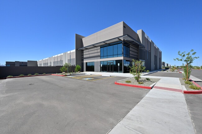

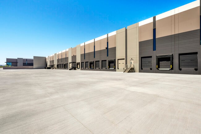
Property Detail
8147 E Pecos Rd
Phoenix-Mesa-Chandler, AZ
MINOR LAND DIVISION MCR 1593-28 LOTS 2 & 3 AKA AS LOT 2A P/F 20230015830
304-61-013J
MARICOPA
Warehouse
Arizona
2025
2a
2025
23.19 AC
422647
Chandler N/Gilbert
420,631 SF
Phoenix
NEARBY LISTINGS FOR SALE OR LEASE
DEMOGRAPHICS near 8147 E Pecos Rd
1 mile
3 mile
5 mile
2025 Total Population
1,226
53,065
191,061
2030 Population
1,280
56,307
202,869
Pop Growth 2025-2030
+ 4.40%
+ 6.11%
+ 6.18%
Average Age
35
36
36
2025 Total Households
347
16,378
58,595
HH Growth 2025-2030
+ 4.61%
+ 6.24%
+ 6.20%
Median Household Inc
$154,494
$132,335
$134,191
Avg Household Size
3.60
3.20
3.20
2025 Avg HH Vehicles
2.00
2.00
2.00
Median Home Value
$669,856
$662,343
$658,317
Median Year Built
2010
2009
2010
Nearby Places
Map Layers
Map Styles
 Street
 Aerial
Transit
 Traffic
 Biking
Places
Listings with unknown addresses are not visible on the map
- Restaurants
- Banks
- Shops
- Fitness
- Groceries
PUBLIC TRANSPORTATION
AIRPORT
Phoenix-Mesa Gateway
Drive
Walk
Distance
Phoenix-Mesa Gateway
6 min
2.4 mi
Phoenix Sky Harbor International
Drive
Walk
Distance
Phoenix Sky Harbor International
45 min
31.3 mi
Freight Ports
Port of San Diego
Drive
Walk
Distance
Port of San Diego
416 min
375.6 mi
SALE & LEASE HISTORY
LISTING DATE
SALE/LEASE

Nov 09, 2022
For Lease
May 19, 2023
For Lease
Nearby Properties
Address
Land Use
TOTAL SIZE
Lot Size
Zoning
Address
Land Use
TOTAL SIZE
Lot Size
Zoning
284.14 AC
Address
Land Use
TOTAL SIZE
Lot Size
Zoning
93,214 SF
10.60 AC
PF
Address
Land Use
TOTAL SIZE
Lot Size
Zoning
64.72 AC
LI
Address
Land Use
TOTAL SIZE
Lot Size
Zoning
481,756 SF
285.61 AC
Address
Land Use
TOTAL SIZE
Lot Size
Zoning
1,200,340 SF
85.82 AC
Address
Land Use
TOTAL SIZE
Lot Size
Zoning
1,358,386 SF
611.30 AC
LI
Address
Land Use
TOTAL SIZE
Lot Size
Zoning
862,568 SF
420.15 AC
PS
Address
Land Use
TOTAL SIZE
Lot Size
Zoning
604,432 SF
56.74 AC
PF
Address
Land Use
TOTAL SIZE
Lot Size
Zoning
1,069,038 SF
69.72 AC
Address
Land Use
TOTAL SIZE
Lot Size
Zoning
298,703 SF
57.08 AC
PF
Address
Land Use
TOTAL SIZE
Lot Size
Zoning
477,934 SF
24.18 AC
MU
Address
Land Use
TOTAL SIZE
Lot Size
Zoning
524,905 SF
40.33 AC
Address
Land Use
TOTAL SIZE
Lot Size
Zoning
245,425 SF
205.62 AC
I-1
Address
Land Use
TOTAL SIZE
Lot Size
Zoning
225,990 SF
26.23 AC
I-1
Address
Land Use
TOTAL SIZE
Lot Size
Zoning
254,314 SF
23.55 AC
R-43
Address
Land Use
TOTAL SIZE
Lot Size
Zoning
21,010 SF
2.72 AC
I-1
Address
Land Use
TOTAL SIZE
Lot Size
Zoning
396,754 SF
46.84 AC
PF
Address
Land Use
TOTAL SIZE
Lot Size
Zoning
583,955 SF
34.92 AC
LI
Address
Land Use
TOTAL SIZE
Lot Size
Zoning
308,343 SF
13.90 AC
MFM
Address
Land Use
TOTAL SIZE
Lot Size
Zoning
266,467 SF
47.47 AC
PF
Address
Land Use
TOTAL SIZE
Lot Size
Zoning
139,348 SF
16.39 AC
R-12
Address
Land Use
TOTAL SIZE
Lot Size
Zoning
614,544 SF
35.40 AC
Address
Land Use
TOTAL SIZE
Lot Size
Zoning
269,550 SF
63.63 AC
Address
Land Use
TOTAL SIZE
Lot Size
Zoning
50,726 SF
633.66 AC
I-1
Address
Land Use
TOTAL SIZE
Lot Size
Zoning
112,957 SF
20 AC
PF/I
Address
Land Use
TOTAL SIZE
Lot Size
Zoning
178,266 SF
16.32 AC
Address
Land Use
TOTAL SIZE
Lot Size
Zoning
121,297 SF
27.91 AC
Address
Land Use
TOTAL SIZE
Lot Size
Zoning
240,833 SF
43.68 AC
PF
Address
Land Use
TOTAL SIZE
Lot Size
Zoning
110,923 SF
32.72 AC
PF
The World's #1 Commercial Real Estate Marketplace
Connect with us
© 2026 CoStar Group
The information above has been obtained from sources believed reliable. While we do not doubt its accuracy we have not verified it and make no guarantee, warranty or representation about it. It is your responsibility to independently confirm its accuracy and completeness. Any projections, opinions, assumptions, or estimates used are for example only and do not represent the current or future performance of the property. The value of this transaction to you depends on tax and other factors which should be evaluated by your tax, financial, and legal advisors. You and your advisors should conduct a careful, independent investigation of the property to determine to your satisfaction the suitability of the property for your needs.