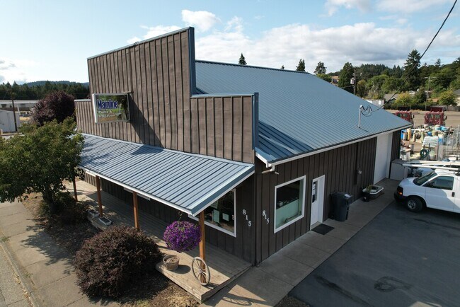
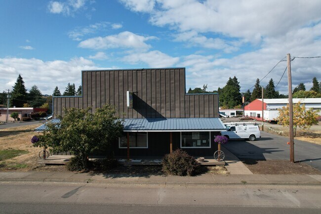
Property Record
815 Applegate St, Philomath, OR 97370
Property Detail
815 Applegate St
416694
PHILOMATH LOT 1
Commercialbuilding
Benton
IL
Oregon
AE The base floodplain where base flood elevations are provided. AE Zones are now used on new format FIRMs instead of A1-A30 Zones.
1
2025
0.24 AC
2025
Oregon West Area
010200
Other Market Areas
2,496 SF
Corvallis, OR
NEARBY LISTINGS FOR SALE OR LEASE
-
-
View all Philomath listings for sale on LoopNet.com
DEMOGRAPHICS near 815 Applegate St
1 mile
3 mile
5 mile
2025 Total Population
3,586
9,202
24,073
2030 Population
3,651
9,388
24,569
Pop Growth 2025-2030
+ 1.81%
+ 2.02%
+ 2.06%
Average Age
42
43
42
2025 Total Households
1,392
3,668
9,969
HH Growth 2025-2030
+ 1.80%
+ 2.02%
+ 2.08%
Median Household Inc
$80,508
$89,848
$89,801
Avg Household Size
2.50
2.50
2.40
2025 Avg HH Vehicles
2.00
2.00
2.00
Median Home Value
$422,081
$498,556
$606,933
Median Year Built
1977
1985
1986
Nearby Places
Map Layers
Map Styles
 Street
 Aerial
Layers
 Traffic
 Biking
Places
Listings with unknown addresses are not visible on the map
- Restaurants
- Banks
- Shops
- Fitness
- Groceries
PUBLIC TRANSPORTATION
AIRPORT
Mahlon Sweet Field
Drive
Walk
Distance
Mahlon Sweet Field
63 min
39.0 mi
Freight Ports
Port of Portland
Drive
Walk
Distance
Port of Portland
120 min
92.4 mi
SALE & LEASE HISTORY
LISTING DATE
SALE/LEASE

Sep 16, 2021
For Sale
Nearby Properties
Address
Land Use
TOTAL SIZE
Lot Size
Zoning
Address
Land Use
TOTAL SIZE
Lot Size
Zoning
241,599 SF
14.33 AC
R-3
Address
Land Use
TOTAL SIZE
Lot Size
Zoning
121,330 SF
10.62 AC
PD(RS-12)
Address
Land Use
TOTAL SIZE
Lot Size
Zoning
15.04 AC
RI
Address
Land Use
TOTAL SIZE
Lot Size
Zoning
Address
Land Use
TOTAL SIZE
Lot Size
Zoning
Address
Land Use
TOTAL SIZE
Lot Size
Zoning
151,681 SF
17.22 AC
IO
Address
Land Use
TOTAL SIZE
Lot Size
Zoning
Address
Land Use
TOTAL SIZE
Lot Size
Zoning
75,776 SF
3.18 AC
MURM
Address
Land Use
TOTAL SIZE
Lot Size
Zoning
40,239 SF
2.51 AC
RS-20
Address
Land Use
TOTAL SIZE
Lot Size
Zoning
Address
Land Use
TOTAL SIZE
Lot Size
Zoning
Address
Land Use
TOTAL SIZE
Lot Size
Zoning
Address
Land Use
TOTAL SIZE
Lot Size
Zoning
1 SF
27.73 AC
IH
Address
Land Use
TOTAL SIZE
Lot Size
Zoning
Address
Land Use
TOTAL SIZE
Lot Size
Zoning
1 SF
19.64 AC
UI
Address
Land Use
TOTAL SIZE
Lot Size
Zoning
Address
Land Use
TOTAL SIZE
Lot Size
Zoning
22.90 AC
RI
Address
Land Use
TOTAL SIZE
Lot Size
Zoning
20,578 SF
1.52 AC
CG
Address
Land Use
TOTAL SIZE
Lot Size
Zoning
Address
Land Use
TOTAL SIZE
Lot Size
Zoning
20,000 SF
7.16 AC
IL
Address
Land Use
TOTAL SIZE
Lot Size
Zoning
42,016 SF
3.51 AC
IO
Address
Land Use
TOTAL SIZE
Lot Size
Zoning
8,073 SF
4.75 AC
RR-2
Address
Land Use
TOTAL SIZE
Lot Size
Zoning
Address
Land Use
TOTAL SIZE
Lot Size
Zoning
18,512 SF
9.32 AC
UI
Address
Land Use
TOTAL SIZE
Lot Size
Zoning
25.02 AC
LDR
Address
Land Use
TOTAL SIZE
Lot Size
Zoning
8,374 SF
2.82 AC
C-2
Address
Land Use
TOTAL SIZE
Lot Size
Zoning
Address
Land Use
TOTAL SIZE
Lot Size
Zoning
3,302 SF
0.56 AC
CG
Address
Land Use
TOTAL SIZE
Lot Size
Zoning
13,504 SF
1.39 AC
MUGC
Address
Land Use
TOTAL SIZE
Lot Size
Zoning
The World's #1 Commercial Real Estate Marketplace
Connect with us
© 2026 CoStar Group
The information above has been obtained from sources believed reliable. While we do not doubt its accuracy we have not verified it and make no guarantee, warranty or representation about it. It is your responsibility to independently confirm its accuracy and completeness. Any projections, opinions, assumptions, or estimates used are for example only and do not represent the current or future performance of the property. The value of this transaction to you depends on tax and other factors which should be evaluated by your tax, financial, and legal advisors. You and your advisors should conduct a careful, independent investigation of the property to determine to your satisfaction the suitability of the property for your needs.