Property Record
815 Chapman Way, Newport News, VA 23608
NEARBY LISTINGS FOR SALE OR LEASE
-
-
View all Newport News listings for lease on LoopNet.com
Property Detail
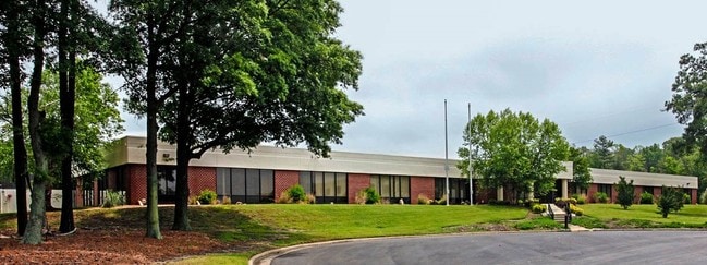
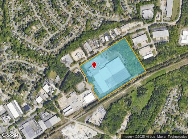
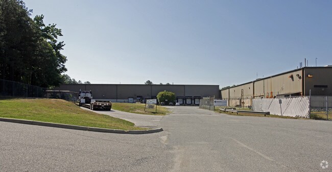
815 Chapman Way
Virginia Beach-Chesapeake-Norfolk, VA-NC
Peninsula Ind Pk
053.00-02-07
LOT A-1
Industrialgeneral
Newport News
X
Virginia
51199C0120D
a-1
2026
20.46 AC
2025
Oakland
032123
Hampton Roads
261,151 SF
DEMOGRAPHICS near 815 Chapman Way
1 Mile
3 Mile
5 Mile
2024 Total Population
9,553
56,784
110,172
2029 Population
9,362
56,190
109,958
Pop Growth 2024-2029
(2.00%)
(1.05%)
(0.19%)
Average Age
36
36
37
2024 Total Households
3,683
21,938
43,310
HH Growth 2024-2029
(2.06%)
(1.09%)
(0.30%)
Median Household Inc
$61,500
$63,255
$70,035
Avg Household Size
2.60
2.40
2.40
2024 Avg HH Vehicles
2.00
2.00
2.00
Median Home Value
$241,815
$223,167
$259,019
Median Year Built
1989
1984
1985
Nearby Places
Map Layers
Map Styles
 Street
 Aerial
- Restaurants
- Banks
- Shops
- Fitness
- Groceries
PUBLIC TRANSPORTATION
COMMUTER RAIL
Newport News (Northeast Regional - Amtrak)
DRIVE
WALK
Distance
Newport News (Northeast Regional - Amtrak)
9 min
5.9 mi
AIRPORT
Newport News/Williamsburg International
DRIVE
WALK
Distance
Newport News/Williamsburg International
10 min
4.4 mi
Norfolk International
DRIVE
WALK
Distance
Norfolk International
47 min
33.3 mi
Freight Ports
Virginia Port Authority - Newport News
DRIVE
WALK
Distance
Virginia Port Authority - Newport News
28 min
21.2 mi
SALE & LEASE HISTORY
LISTING DATE
SALE/LEASE

Sep 25, 2016
For Lease
Nearby Properties
Address
Land Use
TOTAL SIZE
Lot Size
Zoning
Address
Land Use
TOTAL SIZE
Lot Size
Zoning
67,766 SF
7,722.51 AC
R1
Address
Land Use
TOTAL SIZE
Lot Size
Zoning
0.19 AC
R1
Address
Land Use
TOTAL SIZE
Lot Size
Zoning
7,825 SF
0.03 AC
P1
Address
Land Use
TOTAL SIZE
Lot Size
Zoning
4,147 SF
141.50 AC
P1
Address
Land Use
TOTAL SIZE
Lot Size
Zoning
45,382 SF
109.90 AC
M2
Address
Land Use
TOTAL SIZE
Lot Size
Zoning
255,746 SF
46.05 AC
P1
Address
Land Use
TOTAL SIZE
Lot Size
Zoning
139,155 SF
15.01 AC
O2
Address
Land Use
TOTAL SIZE
Lot Size
Zoning
28.29 AC
R7
Address
Land Use
TOTAL SIZE
Lot Size
Zoning
100 SF
24 AC
R7
Address
Land Use
TOTAL SIZE
Lot Size
Zoning
14.98 AC
R7
Address
Land Use
TOTAL SIZE
Lot Size
Zoning
100 SF
10.46 AC
R8
Address
Land Use
TOTAL SIZE
Lot Size
Zoning
29.65 AC
R7
Address
Land Use
TOTAL SIZE
Lot Size
Zoning
197,355 SF
10.89 AC
R8
Address
Land Use
TOTAL SIZE
Lot Size
Zoning
5.04 AC
R9
Address
Land Use
TOTAL SIZE
Lot Size
Zoning
97,180 SF
53.17 AC
C1
Address
Land Use
TOTAL SIZE
Lot Size
Zoning
18.76 AC
R7
Address
Land Use
TOTAL SIZE
Lot Size
Zoning
365,956 SF
27.40 AC
M1
Address
Land Use
TOTAL SIZE
Lot Size
Zoning
21.42 AC
R5
Address
Land Use
TOTAL SIZE
Lot Size
Zoning
290,802 SF
29.47 AC
RMF,GB
Address
Land Use
TOTAL SIZE
Lot Size
Zoning
276,537 SF
27 AC
C1
Address
Land Use
TOTAL SIZE
Lot Size
Zoning
125,000 SF
55.88 AC
P1
Address
Land Use
TOTAL SIZE
Lot Size
Zoning
100 SF
6.90 AC
R7
Address
Land Use
TOTAL SIZE
Lot Size
Zoning
100 SF
13.60 AC
R7
Address
Land Use
TOTAL SIZE
Lot Size
Zoning
13.53 AC
R7
Address
Land Use
TOTAL SIZE
Lot Size
Zoning
139,150 SF
32.52 AC
P1
Address
Land Use
TOTAL SIZE
Lot Size
Zoning
55,570 SF
37.77 AC
M1
Address
Land Use
TOTAL SIZE
Lot Size
Zoning
8.90 AC
R9
Address
Land Use
TOTAL SIZE
Lot Size
Zoning
1,669.43 AC
RESOURCE C
Address
Land Use
TOTAL SIZE
Lot Size
Zoning
151,883 SF
25.31 AC
M2
Address
Land Use
TOTAL SIZE
Lot Size
Zoning
260,283 SF
19.98 AC
M2
The World's #1 Commercial Real Estate Marketplace
Connect with us
© 2026 CoStar Group
The information above has been obtained from sources believed reliable. While we do not doubt its accuracy we have not verified it and make no guarantee, warranty or representation about it. It is your responsibility to independently confirm its accuracy and completeness. Any projections, opinions, assumptions, or estimates used are for example only and do not represent the current or future performance of the property. The value of this transaction to you depends on tax and other factors which should be evaluated by your tax, financial, and legal advisors. You and your advisors should conduct a careful, independent investigation of the property to determine to your satisfaction the suitability of the property for your needs.