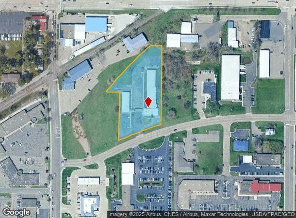
Property Record
815 1St St S, Waite Park, MN 56387
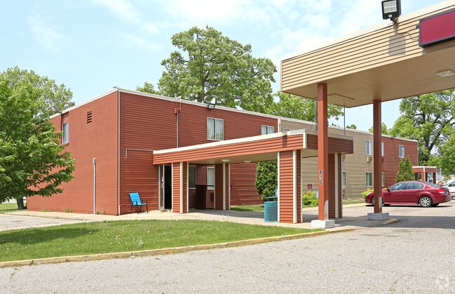
This Property Is For Sale
NEARBY LISTINGS FOR SALE OR LEASE
-
-
View all Waite Park listings for sale on LoopNet.com
Property Detail
815 1St St S
98.60541.0000
See attachment
Motel
Stearns
X
Minnesota
27145C0640E
2.44 AC
2024
Minnesota Central Area
2025
Minneapolis/St Paul
000501
St. Cloud, MN
14,253 SF
DEMOGRAPHICS near 815 1St St S
1 Mile
3 Mile
5 Mile
2024 Total Population
7,722
46,443
109,200
2029 Population
8,022
48,128
112,851
Pop Growth 2024-2029
+ 3.89%
+ 3.63%
+ 3.34%
Average Age
38
38
37
2024 Total Households
3,338
19,241
43,238
HH Growth 2024-2029
+ 3.95%
+ 3.72%
+ 3.43%
Median Household Inc
$44,631
$56,211
$55,603
Avg Household Size
2.20
2.30
2.30
2024 Avg HH Vehicles
2.00
2.00
2.00
Median Home Value
$205,831
$185,327
$194,222
Median Year Built
1989
1984
1985
Nearby Places
Map Layers
Map Styles
 Street
 Aerial
- Restaurants
- Banks
- Shops
- Fitness
- Groceries
PUBLIC TRANSPORTATION
COMMUTER RAIL
St. Cloud Amtrak Station (Empire Builder - Amtrak)
DRIVE
WALK
Distance
St. Cloud Amtrak Station (Empire Builder - Amtrak)
10 min
4.7 mi
Freight Ports
Port Milwaukee
DRIVE
WALK
Distance
Port Milwaukee
452 min
405.8 mi
Nearby Properties
Address
Land Use
TOTAL SIZE
Lot Size
Zoning
Address
Land Use
TOTAL SIZE
Lot Size
Zoning
307,404 SF
105.31 AC
Address
Land Use
TOTAL SIZE
Lot Size
Zoning
38.97 AC
Address
Land Use
TOTAL SIZE
Lot Size
Zoning
639,000 SF
216.67 AC
PUD28
Address
Land Use
TOTAL SIZE
Lot Size
Zoning
113,316 SF
31.99 AC
Address
Land Use
TOTAL SIZE
Lot Size
Zoning
107,306 SF
2.11 AC
C4
Address
Land Use
TOTAL SIZE
Lot Size
Zoning
105,833 SF
4.61 AC
C4
Address
Land Use
TOTAL SIZE
Lot Size
Zoning
52,983 SF
22 AC
Address
Land Use
TOTAL SIZE
Lot Size
Zoning
70,971 SF
11.40 AC
PUD57
Address
Land Use
TOTAL SIZE
Lot Size
Zoning
19.06 AC
Address
Land Use
TOTAL SIZE
Lot Size
Zoning
125,278 SF
11.01 AC
C5
Address
Land Use
TOTAL SIZE
Lot Size
Zoning
344,031 SF
64.88 AC
PUD28
Address
Land Use
TOTAL SIZE
Lot Size
Zoning
184,285 SF
13.37 AC
Address
Land Use
TOTAL SIZE
Lot Size
Zoning
628,000 SF
40.51 AC
PUD16
Address
Land Use
TOTAL SIZE
Lot Size
Zoning
115,298 SF
8.50 AC
R5
Address
Land Use
TOTAL SIZE
Lot Size
Zoning
5.34 AC
Address
Land Use
TOTAL SIZE
Lot Size
Zoning
233,354 SF
7.30 AC
R5
Address
Land Use
TOTAL SIZE
Lot Size
Zoning
113,268 SF
12 AC
PUD32
Address
Land Use
TOTAL SIZE
Lot Size
Zoning
19.83 AC
Address
Land Use
TOTAL SIZE
Lot Size
Zoning
146,285 SF
19.10 AC
Address
Land Use
TOTAL SIZE
Lot Size
Zoning
51.70 AC
PL20B2
Address
Land Use
TOTAL SIZE
Lot Size
Zoning
555,652 SF
26.04 AC
PUD16
Address
Land Use
TOTAL SIZE
Lot Size
Zoning
25,608 SF
6.96 AC
R5
Address
Land Use
TOTAL SIZE
Lot Size
Zoning
36,393 SF
6.28 AC
Address
Land Use
TOTAL SIZE
Lot Size
Zoning
83,317 SF
6.43 AC
C5
Address
Land Use
TOTAL SIZE
Lot Size
Zoning
289,470 SF
23 AC
I3
Address
Land Use
TOTAL SIZE
Lot Size
Zoning
44,223 SF
12.31 AC
Address
Land Use
TOTAL SIZE
Lot Size
Zoning
135,964 SF
57.06 AC
PUD28
Address
Land Use
TOTAL SIZE
Lot Size
Zoning
288,861 SF
30.27 AC
I3
Address
Land Use
TOTAL SIZE
Lot Size
Zoning
18,554 SF
8.41 AC
Address
Land Use
TOTAL SIZE
Lot Size
Zoning
165,878 SF
11.17 AC
PUD56
The World's #1 Commercial Real Estate Marketplace
Connect with us
© 2025 CoStar Group
The information above has been obtained from sources believed reliable. While we do not doubt its accuracy we have not verified it and make no guarantee, warranty or representation about it. It is your responsibility to independently confirm its accuracy and completeness. Any projections, opinions, assumptions, or estimates used are for example only and do not represent the current or future performance of the property. The value of this transaction to you depends on tax and other factors which should be evaluated by your tax, financial, and legal advisors. You and your advisors should conduct a careful, independent investigation of the property to determine to your satisfaction the suitability of the property for your needs.