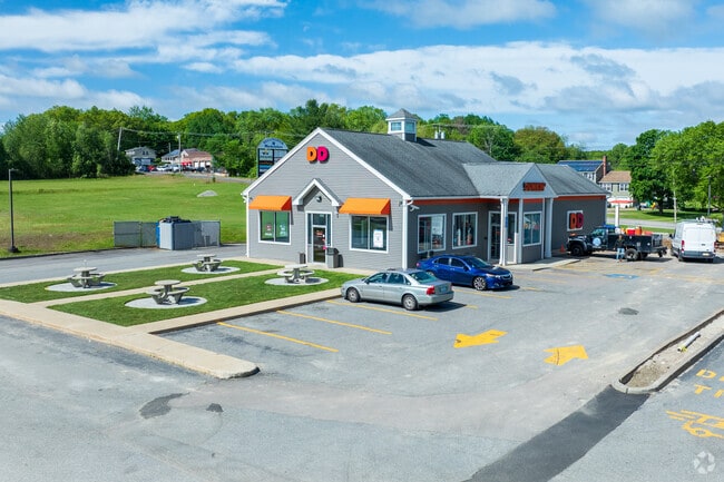
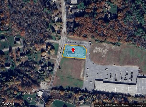
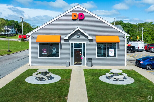
Property Record
815 S Main St, Bellingham, MA 02019
NEARBY LISTINGS FOR SALE OR LEASE
Property Detail
815 S Main St
BELL-000075-000013-000001
Norfolk
Storebuilding
Massachusetts
X
1
25021C0311F
0.92 AC
2025
I-95 Corridor South
2025
Boston
443104
Boston-Cambridge-Newton, MA-NH
3,304 SF
DEMOGRAPHICS near 815 S Main St
1 Mile
3 Mile
5 Mile
2024 Total Population
3,149
28,530
93,905
2029 Population
3,118
28,340
93,125
Pop Growth 2024-2029
(0.98%)
(0.67%)
(0.83%)
Average Age
41
41
41
2024 Total Households
1,125
11,035
37,610
HH Growth 2024-2029
(1.07%)
(0.72%)
(0.91%)
Median Household Inc
$132,057
$96,091
$77,241
Avg Household Size
2.80
2.50
2.40
2024 Avg HH Vehicles
2.00
2.00
2.00
Median Home Value
$416,109
$370,505
$367,899
Median Year Built
1971
1973
1965
Nearby Places
Map Layers
Map Styles
 Street
 Aerial
- Restaurants
- Banks
- Shops
- Fitness
- Groceries
PUBLIC TRANSPORTATION
COMMUTER RAIL
Forge Park/Route 495 (Franklin Line - Massachusetts Bay Transportation Authority Commuter Rail (Purple Line))
DRIVE
WALK
Distance
Forge Park/Route 495 (Franklin Line - Massachusetts Bay Transportation Authority Commuter Rail (Purple Line))
11 min
4.8 mi
Franklin (Franklin Line - Massachusetts Bay Transportation Authority Commuter Rail (Purple Line))
DRIVE
WALK
Distance
Franklin (Franklin Line - Massachusetts Bay Transportation Authority Commuter Rail (Purple Line))
13 min
6.6 mi
AIRPORT
Rhode Island Tf Green International
DRIVE
WALK
Distance
Rhode Island Tf Green International
40 min
26.1 mi
Worcester Regional
DRIVE
WALK
Distance
Worcester Regional
52 min
36.0 mi
General Edward Lawrence Logan International
DRIVE
WALK
Distance
General Edward Lawrence Logan International
68 min
49.7 mi
Nearby Properties
Address
Land Use
TOTAL SIZE
Lot Size
Zoning
Address
Land Use
TOTAL SIZE
Lot Size
Zoning
20.97 AC
CRPC
Address
Land Use
TOTAL SIZE
Lot Size
Zoning
14.82 AC
AGR
Address
Land Use
TOTAL SIZE
Lot Size
Zoning
345,000 SF
60.44 AC
BUS1
Address
Land Use
TOTAL SIZE
Lot Size
Zoning
238,602 SF
109.37 AC
Address
Land Use
TOTAL SIZE
Lot Size
Zoning
75,140 SF
39.40 AC
Address
Land Use
TOTAL SIZE
Lot Size
Zoning
7,580 SF
32.61 AC
R4
Address
Land Use
TOTAL SIZE
Lot Size
Zoning
208,826 SF
18.96 AC
IND
Address
Land Use
TOTAL SIZE
Lot Size
Zoning
203,792 SF
27.93 AC
IND
Address
Land Use
TOTAL SIZE
Lot Size
Zoning
16.49 AC
PR1
Address
Land Use
TOTAL SIZE
Lot Size
Zoning
5,520 SF
9.81 AC
R1
Address
Land Use
TOTAL SIZE
Lot Size
Zoning
124,320 SF
10 AC
BUS1
Address
Land Use
TOTAL SIZE
Lot Size
Zoning
19,774 SF
23.53 AC
R1
Address
Land Use
TOTAL SIZE
Lot Size
Zoning
8.33 AC
R2
Address
Land Use
TOTAL SIZE
Lot Size
Zoning
112,894 SF
9.96 AC
Address
Land Use
TOTAL SIZE
Lot Size
Zoning
154,000 SF
21.92 AC
Address
Land Use
TOTAL SIZE
Lot Size
Zoning
14.05 AC
Address
Land Use
TOTAL SIZE
Lot Size
Zoning
128,693 SF
28.30 AC
Address
Land Use
TOTAL SIZE
Lot Size
Zoning
143,208 SF
23.22 AC
Address
Land Use
TOTAL SIZE
Lot Size
Zoning
45,454 SF
4.78 AC
CRPC
Address
Land Use
TOTAL SIZE
Lot Size
Zoning
65,093 SF
4.65 AC
R4
Address
Land Use
TOTAL SIZE
Lot Size
Zoning
23.19 AC
C2
Address
Land Use
TOTAL SIZE
Lot Size
Zoning
49,920 SF
8.77 AC
IND
Address
Land Use
TOTAL SIZE
Lot Size
Zoning
110,931 SF
46.97 AC
Address
Land Use
TOTAL SIZE
Lot Size
Zoning
8.25 AC
C2
Address
Land Use
TOTAL SIZE
Lot Size
Zoning
65,698 SF
19.07 AC
B
Address
Land Use
TOTAL SIZE
Lot Size
Zoning
34,933 SF
6.37 AC
IND
Address
Land Use
TOTAL SIZE
Lot Size
Zoning
13,688 SF
320.62 AC
Address
Land Use
TOTAL SIZE
Lot Size
Zoning
23.21 AC
C2
Address
Land Use
TOTAL SIZE
Lot Size
Zoning
36,026 SF
4.03 AC
RES
Address
Land Use
TOTAL SIZE
Lot Size
Zoning
2,270 SF
71.25 AC
IND
The World's #1 Commercial Real Estate Marketplace
Connect with us
© 2025 CoStar Group
The information above has been obtained from sources believed reliable. While we do not doubt its accuracy we have not verified it and make no guarantee, warranty or representation about it. It is your responsibility to independently confirm its accuracy and completeness. Any projections, opinions, assumptions, or estimates used are for example only and do not represent the current or future performance of the property. The value of this transaction to you depends on tax and other factors which should be evaluated by your tax, financial, and legal advisors. You and your advisors should conduct a careful, independent investigation of the property to determine to your satisfaction the suitability of the property for your needs.