Property Record
815 Us Highway 27, Cataula, GA 31804
NEARBY LISTINGS FOR SALE OR LEASE
Property Detail
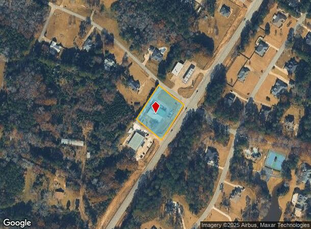
815 Us Highway 27
Columbus, GA-AL
Cataula Downs
048-143
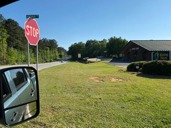
PARCEL B - 1 RISING STARS CHILD CARE
Daycare
Harris
X
Georgia
13145C0285C
1
2025
1.09 AC
2025
Harris County
120401
Columbus GA
5,925 SF
DEMOGRAPHICS near 815 Us Highway 27
1 Mile
3 Mile
5 Mile
2024 Total Population
1,147
5,962
29,940
2029 Population
1,293
6,562
30,848
Pop Growth 2024-2029
+ 12.73%
+ 10.06%
+ 3.03%
Average Age
43
40
38
2024 Total Households
421
2,188
11,686
HH Growth 2024-2029
+ 12.59%
+ 9.83%
+ 2.45%
Median Household Inc
$109,318
$105,750
$89,114
Avg Household Size
2.70
2.70
2.50
2024 Avg HH Vehicles
2.00
2.00
2.00
Median Home Value
$314,674
$310,282
$283,637
Median Year Built
1994
2000
2001
Nearby Places
Map Layers
Map Styles
 Street
 Aerial
- Restaurants
- Banks
- Shops
- Fitness
- Groceries
PUBLIC TRANSPORTATION
AIRPORT
Columbus
DRIVE
WALK
Distance
Columbus
16 min
9.0 mi
SALE & LEASE HISTORY
LISTING DATE
SALE/LEASE

Jun 04, 2020
For Lease
Nearby Properties
Address
Land Use
TOTAL SIZE
Lot Size
Zoning
Address
Land Use
TOTAL SIZE
Lot Size
Zoning
1,010 SF
38.44 AC
Address
Land Use
TOTAL SIZE
Lot Size
Zoning
928 SF
40.08 AC
Address
Land Use
TOTAL SIZE
Lot Size
Zoning
933.05 AC
004
Address
Land Use
TOTAL SIZE
Lot Size
Zoning
16.91 AC
Address
Land Use
TOTAL SIZE
Lot Size
Zoning
1,080 SF
61.49 AC
Address
Land Use
TOTAL SIZE
Lot Size
Zoning
9,301 SF
2.60 AC
Address
Land Use
TOTAL SIZE
Lot Size
Zoning
1,491 SF
19.55 AC
Address
Land Use
TOTAL SIZE
Lot Size
Zoning
3,000 SF
4.94 AC
002
Address
Land Use
TOTAL SIZE
Lot Size
Zoning
1,232 SF
19.93 AC
Address
Land Use
TOTAL SIZE
Lot Size
Zoning
6,047 SF
20.70 AC
Address
Land Use
TOTAL SIZE
Lot Size
Zoning
2,700 SF
1 AC
Address
Land Use
TOTAL SIZE
Lot Size
Zoning
56.20 AC
Address
Land Use
TOTAL SIZE
Lot Size
Zoning
161.68 AC
Address
Land Use
TOTAL SIZE
Lot Size
Zoning
2,919 SF
32.30 AC
Address
Land Use
TOTAL SIZE
Lot Size
Zoning
Address
Land Use
TOTAL SIZE
Lot Size
Zoning
10,927 SF
5.37 AC
Address
Land Use
TOTAL SIZE
Lot Size
Zoning
2,103 SF
41.98 AC
Address
Land Use
TOTAL SIZE
Lot Size
Zoning
4,400 SF
8.04 AC
Address
Land Use
TOTAL SIZE
Lot Size
Zoning
3,240 SF
1.65 AC
Address
Land Use
TOTAL SIZE
Lot Size
Zoning
3,108 SF
1.44 AC
001
Address
Land Use
TOTAL SIZE
Lot Size
Zoning
19.34 AC
Address
Land Use
TOTAL SIZE
Lot Size
Zoning
49.27 AC
Address
Land Use
TOTAL SIZE
Lot Size
Zoning
25.03 AC
Address
Land Use
TOTAL SIZE
Lot Size
Zoning
5,084 SF
7.86 AC
Address
Land Use
TOTAL SIZE
Lot Size
Zoning
238.96 AC
004
Address
Land Use
TOTAL SIZE
Lot Size
Zoning
6,696 SF
2 AC
Address
Land Use
TOTAL SIZE
Lot Size
Zoning
9,000 SF
11.50 AC
002
Address
Land Use
TOTAL SIZE
Lot Size
Zoning
2,208 SF
1.20 AC
Address
Land Use
TOTAL SIZE
Lot Size
Zoning
3,847 SF
7.88 AC
Address
Land Use
TOTAL SIZE
Lot Size
Zoning
968 SF
79.03 AC
The World's #1 Commercial Real Estate Marketplace
Connect with us
© 2026 CoStar Group
The information above has been obtained from sources believed reliable. While we do not doubt its accuracy we have not verified it and make no guarantee, warranty or representation about it. It is your responsibility to independently confirm its accuracy and completeness. Any projections, opinions, assumptions, or estimates used are for example only and do not represent the current or future performance of the property. The value of this transaction to you depends on tax and other factors which should be evaluated by your tax, financial, and legal advisors. You and your advisors should conduct a careful, independent investigation of the property to determine to your satisfaction the suitability of the property for your needs.