Property Record
815 W Lucy St, Homestead, FL 33034


NEARBY LISTINGS FOR SALE OR LEASE
Property Detail
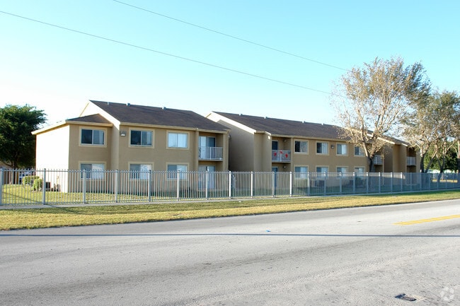
815 W Lucy St
16-7824-031-0010
Florida Apartments
Multifamilydwelling
FLORIDA APARTMENTS PB 146-56 T-18704 TR A LOT SIZE 7.101 AC M/L FAU 16-7824-000-0120 OR 16434-0861 0694 1
X
Miami/Dade
12086C0730L
Florida
2024
7.10 AC
2025
Outer Homestead/South Dade
011302
South Florida
121,635 SF
Miami-Miami Beach-Kendall, FL
DEMOGRAPHICS near 815 W Lucy St
1 Mile
3 Mile
5 Mile
2024 Total Population
15,905
74,028
132,067
2029 Population
15,687
72,387
129,409
Pop Growth 2024-2029
(1.37%)
(2.22%)
(2.01%)
Average Age
34
35
36
2024 Total Households
4,659
22,279
38,906
HH Growth 2024-2029
(1.70%)
(2.63%)
(2.47%)
Median Household Inc
$29,094
$47,184
$53,602
Avg Household Size
3.30
3.20
3.20
2024 Avg HH Vehicles
1.00
2.00
2.00
Median Home Value
$250,679
$302,840
$308,919
Median Year Built
1984
1992
1996
Nearby Places
Map Layers
Map Styles
 Street
 Aerial
- Restaurants
- Banks
- Shops
- Fitness
- Groceries
PUBLIC TRANSPORTATION
AIRPORT
Miami International
DRIVE
WALK
Distance
Miami International
47 min
33.1 mi
Freight Ports
Port of Miami
DRIVE
WALK
Distance
Port of Miami
56 min
40.2 mi
Nearby Properties
Address
Land Use
TOTAL SIZE
Lot Size
Zoning
Address
Land Use
TOTAL SIZE
Lot Size
Zoning
149,022 SF
34.85 AC
9300
Address
Land Use
TOTAL SIZE
Lot Size
Zoning
216,282 SF
20.04 AC
6300
Address
Land Use
TOTAL SIZE
Lot Size
Zoning
183,244 SF
4 AC
6500
Address
Land Use
TOTAL SIZE
Lot Size
Zoning
122,719 SF
18.62 AC
9000
Address
Land Use
TOTAL SIZE
Lot Size
Zoning
304,629 SF
36.34 AC
0100
Address
Land Use
TOTAL SIZE
Lot Size
Zoning
252,526 SF
29.86 AC
6000
Address
Land Use
TOTAL SIZE
Lot Size
Zoning
169,474 SF
5.76 AC
6300
Address
Land Use
TOTAL SIZE
Lot Size
Zoning
278,375 SF
20.15 AC
7000
Address
Land Use
TOTAL SIZE
Lot Size
Zoning
208,951 SF
20 AC
6300
Address
Land Use
TOTAL SIZE
Lot Size
Zoning
409,347 SF
33.88 AC
3000
Address
Land Use
TOTAL SIZE
Lot Size
Zoning
322,425 SF
16.40 AC
5700
Address
Land Use
TOTAL SIZE
Lot Size
Zoning
119,534 SF
8.55 AC
6200
Address
Land Use
TOTAL SIZE
Lot Size
Zoning
203,528 SF
3.73 AC
6000
Address
Land Use
TOTAL SIZE
Lot Size
Zoning
234,124 SF
23.35 AC
6000
Address
Land Use
TOTAL SIZE
Lot Size
Zoning
374,632 SF
23.28 AC
3000
Address
Land Use
TOTAL SIZE
Lot Size
Zoning
24.37 AC
6600
Address
Land Use
TOTAL SIZE
Lot Size
Zoning
96,971 SF
3.08 AC
6500
Address
Land Use
TOTAL SIZE
Lot Size
Zoning
146,483 SF
20 AC
8900
Address
Land Use
TOTAL SIZE
Lot Size
Zoning
165,761 SF
6.72 AC
6300
Address
Land Use
TOTAL SIZE
Lot Size
Zoning
431,236 SF
2.74 AC
9450
Address
Land Use
TOTAL SIZE
Lot Size
Zoning
84,500 SF
2.90 AC
7000
Address
Land Use
TOTAL SIZE
Lot Size
Zoning
177,485 SF
14.71 AC
6300
Address
Land Use
TOTAL SIZE
Lot Size
Zoning
102,707 SF
3.63 AC
9200
Address
Land Use
TOTAL SIZE
Lot Size
Zoning
126,637 SF
9.70 AC
6500
Address
Land Use
TOTAL SIZE
Lot Size
Zoning
49.95 AC
9300
Address
Land Use
TOTAL SIZE
Lot Size
Zoning
101,327 SF
0.69 AC
8000
Address
Land Use
TOTAL SIZE
Lot Size
Zoning
114,525 SF
13.74 AC
6400
Address
Land Use
TOTAL SIZE
Lot Size
Zoning
60,273 SF
5.22 AC
2800
The World's #1 Commercial Real Estate Marketplace
Connect with us
© 2026 CoStar Group
The information above has been obtained from sources believed reliable. While we do not doubt its accuracy we have not verified it and make no guarantee, warranty or representation about it. It is your responsibility to independently confirm its accuracy and completeness. Any projections, opinions, assumptions, or estimates used are for example only and do not represent the current or future performance of the property. The value of this transaction to you depends on tax and other factors which should be evaluated by your tax, financial, and legal advisors. You and your advisors should conduct a careful, independent investigation of the property to determine to your satisfaction the suitability of the property for your needs.