Property Record
815 W Ocean Ave, Lompoc, CA 93436
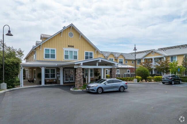

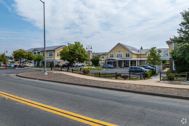
Property Detail
815 W Ocean Ave
Santa Maria-Santa Barbara, CA
Santa Barbara
141-380-045
California
Apartment
1
B and X Area of moderate flood hazard, usually the area between the limits of the 100-year and 500-year floods.
2.20 AC
2024
Santa Ynez
2025
Santa Barbara/Sta Maria/Goleta
002709
NEARBY LISTINGS FOR SALE OR LEASE
-
-
View all Lompoc listings for sale on LoopNet.com
DEMOGRAPHICS near 815 W Ocean Ave
1 mile
3 mile
5 mile
2025 Total Population
2,424
10,092
13,474
2030 Population
2,303
9,706
12,884
Pop Growth 2025-2030
(4.99%)
(3.82%)
(4.38%)
Average Age
46
46
46
2025 Total Households
944
3,943
5,238
HH Growth 2025-2030
(5.19%)
(3.98%)
(4.58%)
Median Household Inc
$109,146
$118,545
$118,945
Avg Household Size
2.50
2.50
2.40
2025 Avg HH Vehicles
3.00
2.00
2.00
Median Home Value
$1,103,143
$1,076,585
$1,076,016
Median Year Built
1974
1979
1979
Nearby Places
Map Layers
Map Styles
 Street
 Aerial
Transit
 Traffic
 Biking
Places
Listings with unknown addresses are not visible on the map
- Restaurants
- Banks
- Shops
- Fitness
- Groceries
PUBLIC TRANSPORTATION
COMMUTER RAIL
Lompoc-Surf Amtrak (Pacific Surfliner - Amtrak)
Drive
Walk
Distance
Lompoc-Surf Amtrak (Pacific Surfliner - Amtrak)
16 min
9.1 mi
Freight Ports
The Port of Hueneme
Drive
Walk
Distance
The Port of Hueneme
121 min
94.1 mi
Nearby Properties
Address
Land Use
TOTAL SIZE
Lot Size
Zoning
Address
Land Use
TOTAL SIZE
Lot Size
Zoning
13.68 AC
Address
Land Use
TOTAL SIZE
Lot Size
Zoning
960 SF
710.58 AC
AGII100
Address
Land Use
TOTAL SIZE
Lot Size
Zoning
9.42 AC
Address
Land Use
TOTAL SIZE
Lot Size
Zoning
7.37 AC
Address
Land Use
TOTAL SIZE
Lot Size
Zoning
12.86 AC
Address
Land Use
TOTAL SIZE
Lot Size
Zoning
4.85 AC
Address
Land Use
TOTAL SIZE
Lot Size
Zoning
4.71 AC
Address
Land Use
TOTAL SIZE
Lot Size
Zoning
6.55 AC
Address
Land Use
TOTAL SIZE
Lot Size
Zoning
2.78 AC
Address
Land Use
TOTAL SIZE
Lot Size
Zoning
1.09 AC
Address
Land Use
TOTAL SIZE
Lot Size
Zoning
2.17 AC
Address
Land Use
TOTAL SIZE
Lot Size
Zoning
0.99 AC
Address
Land Use
TOTAL SIZE
Lot Size
Zoning
7.34 AC
Address
Land Use
TOTAL SIZE
Lot Size
Zoning
12.02 AC
Address
Land Use
TOTAL SIZE
Lot Size
Zoning
4.36 AC
Address
Land Use
TOTAL SIZE
Lot Size
Zoning
2.35 AC
Address
Land Use
TOTAL SIZE
Lot Size
Zoning
Address
Land Use
TOTAL SIZE
Lot Size
Zoning
3.15 AC
Address
Land Use
TOTAL SIZE
Lot Size
Zoning
3.21 AC
Address
Land Use
TOTAL SIZE
Lot Size
Zoning
8.64 AC
Address
Land Use
TOTAL SIZE
Lot Size
Zoning
6.94 AC
Address
Land Use
TOTAL SIZE
Lot Size
Zoning
3.29 AC
Address
Land Use
TOTAL SIZE
Lot Size
Zoning
2.28 AC
Address
Land Use
TOTAL SIZE
Lot Size
Zoning
2.17 AC
Address
Land Use
TOTAL SIZE
Lot Size
Zoning
8.78 AC
Address
Land Use
TOTAL SIZE
Lot Size
Zoning
2.02 AC
Address
Land Use
TOTAL SIZE
Lot Size
Zoning
37.21 AC
Address
Land Use
TOTAL SIZE
Lot Size
Zoning
3.92 AC
Address
Land Use
TOTAL SIZE
Lot Size
Zoning
1.16 AC
The World's #1 Commercial Real Estate Marketplace
Connect with us
© 2026 CoStar Group
The information above has been obtained from sources believed reliable. While we do not doubt its accuracy we have not verified it and make no guarantee, warranty or representation about it. It is your responsibility to independently confirm its accuracy and completeness. Any projections, opinions, assumptions, or estimates used are for example only and do not represent the current or future performance of the property. The value of this transaction to you depends on tax and other factors which should be evaluated by your tax, financial, and legal advisors. You and your advisors should conduct a careful, independent investigation of the property to determine to your satisfaction the suitability of the property for your needs.