Property Record
8150 Mcclellan Blvd, Anniston, AL 36206
NEARBY LISTINGS FOR SALE OR LEASE
Property Detail
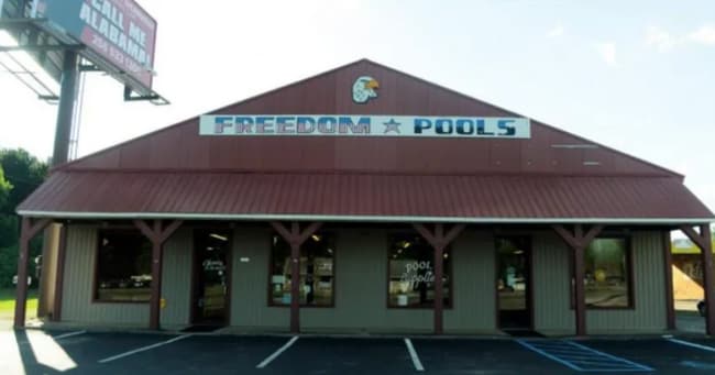
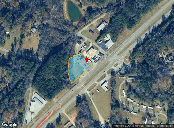
8150 Mcclellan Blvd
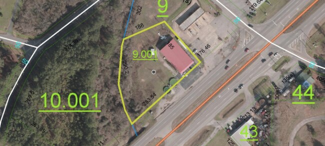
18-02-03-0-001-009.001
Se1/4 Of The Nw1/4 Of The Ne1/4 Of The S
Storebuilding
SEC 03 TSP 15S RNG 08E A LOT IN NE 1/4 OF SW 1/4 & SE 1/4 O F NW 1/4 OF SEC 3 DESC AS FOL BEG @ PT ON NW LN OF ALA HYWY 21 BE
A
Calhoun
01015C0168E
Alabama
2025
1.27 AC
2025
Gadsden/Anniston Area
001801
Other Market Areas
6,000 SF
Anniston-Oxford-Jacksonville, AL
DEMOGRAPHICS near 8150 Mcclellan Blvd
1 Mile
3 Mile
5 Mile
2024 Total Population
1,002
9,747
29,853
2029 Population
988
9,590
29,365
Pop Growth 2024-2029
(1.40%)
(1.61%)
(1.63%)
Average Age
40
40
38
2024 Total Households
410
3,981
11,651
HH Growth 2024-2029
(1.46%)
(1.56%)
(1.68%)
Median Household Inc
$41,136
$54,199
$45,710
Avg Household Size
2.40
2.40
2.30
2024 Avg HH Vehicles
2.00
2.00
2.00
Median Home Value
$138,343
$141,081
$134,889
Median Year Built
1974
1977
1979
Nearby Places
Map Layers
Map Styles
 Street
 Aerial
- Restaurants
- Banks
- Shops
- Fitness
- Groceries
PUBLIC TRANSPORTATION
COMMUTER RAIL
Anniston Amtrak Station (Crescent - Amtrak)
DRIVE
WALK
Distance
Anniston Amtrak Station (Crescent - Amtrak)
13 min
8.4 mi
Freight Ports
Port of Panama City
DRIVE
WALK
Distance
Port of Panama City
375 min
300.2 mi
SALE & LEASE HISTORY
LISTING DATE
SALE/LEASE

Nov 27, 2020
For Sale
Nearby Properties
Address
Land Use
TOTAL SIZE
Lot Size
Zoning
Address
Land Use
TOTAL SIZE
Lot Size
Zoning
2,784 SF
17 AC
Address
Land Use
TOTAL SIZE
Lot Size
Zoning
20,074 SF
12 AC
Address
Land Use
TOTAL SIZE
Lot Size
Zoning
5,054 SF
11 AC
Address
Land Use
TOTAL SIZE
Lot Size
Zoning
163,080 SF
17 AC
Address
Land Use
TOTAL SIZE
Lot Size
Zoning
203,573 SF
17.16 AC
Address
Land Use
TOTAL SIZE
Lot Size
Zoning
133,349 SF
6.80 AC
Address
Land Use
TOTAL SIZE
Lot Size
Zoning
127,717 SF
10 AC
Address
Land Use
TOTAL SIZE
Lot Size
Zoning
40,266 SF
16 AC
Address
Land Use
TOTAL SIZE
Lot Size
Zoning
Address
Land Use
TOTAL SIZE
Lot Size
Zoning
23,512 SF
4.60 AC
Address
Land Use
TOTAL SIZE
Lot Size
Zoning
51,145 SF
2.49 AC
Address
Land Use
TOTAL SIZE
Lot Size
Zoning
3,360 SF
10.80 AC
Address
Land Use
TOTAL SIZE
Lot Size
Zoning
14,208 SF
19 AC
Address
Land Use
TOTAL SIZE
Lot Size
Zoning
12,114 SF
7.10 AC
Address
Land Use
TOTAL SIZE
Lot Size
Zoning
35,580 SF
3.48 AC
Address
Land Use
TOTAL SIZE
Lot Size
Zoning
56,080 SF
5.15 AC
Address
Land Use
TOTAL SIZE
Lot Size
Zoning
25,993 SF
6.05 AC
Address
Land Use
TOTAL SIZE
Lot Size
Zoning
7,776 SF
1.85 AC
Address
Land Use
TOTAL SIZE
Lot Size
Zoning
12,768 SF
5 AC
Address
Land Use
TOTAL SIZE
Lot Size
Zoning
26,654 SF
10 AC
Address
Land Use
TOTAL SIZE
Lot Size
Zoning
3,504 SF
6.74 AC
Address
Land Use
TOTAL SIZE
Lot Size
Zoning
15,518 SF
24 AC
Address
Land Use
TOTAL SIZE
Lot Size
Zoning
Address
Land Use
TOTAL SIZE
Lot Size
Zoning
56,920 SF
3 AC
Address
Land Use
TOTAL SIZE
Lot Size
Zoning
19.22 AC
Address
Land Use
TOTAL SIZE
Lot Size
Zoning
1,800 SF
6.40 AC
Address
Land Use
TOTAL SIZE
Lot Size
Zoning
19,137 SF
3.82 AC
Address
Land Use
TOTAL SIZE
Lot Size
Zoning
36,182 SF
3.24 AC
Address
Land Use
TOTAL SIZE
Lot Size
Zoning
1,751 SF
8.30 AC
Address
Land Use
TOTAL SIZE
Lot Size
Zoning
13.69 AC
The World's #1 Commercial Real Estate Marketplace
Connect with us
© 2025 CoStar Group
The information above has been obtained from sources believed reliable. While we do not doubt its accuracy we have not verified it and make no guarantee, warranty or representation about it. It is your responsibility to independently confirm its accuracy and completeness. Any projections, opinions, assumptions, or estimates used are for example only and do not represent the current or future performance of the property. The value of this transaction to you depends on tax and other factors which should be evaluated by your tax, financial, and legal advisors. You and your advisors should conduct a careful, independent investigation of the property to determine to your satisfaction the suitability of the property for your needs.