Property Record
816 Cedar St, Beaufort, NC 28516
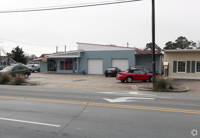


Property Detail
816 Cedar St
Morehead City, NC
L4 7 FLOYD LOFTIN SD
7306.18.30.8332000
Carteret
Storebuilding
North Carolina
B and X Area of moderate flood hazard, usually the area between the limits of the 100-year and 500-year floods.
4,7
2025
0.27 AC
2025
Coastal Carolina
970305
Other Market Areas
2,501 SF
NEARBY LISTINGS FOR SALE OR LEASE
DEMOGRAPHICS near 816 Cedar St
1 mile
3 mile
5 mile
2024 Total Population
2,847
6,590
14,860
2029 Population
2,953
6,754
15,280
Pop Growth 2024-2029
+ 3.72%
+ 2.49%
+ 2.83%
Average Age
49
48
48
2024 Total Households
1,410
3,206
7,134
HH Growth 2024-2029
+ 4.11%
+ 2.87%
+ 3.50%
Median Household Inc
$76,042
$69,695
$69,512
Avg Household Size
1.90
2.00
2.00
2024 Avg HH Vehicles
2.00
2.00
2.00
Median Home Value
$482,473
$370,766
$379,238
Median Year Built
1970
1979
1982
Nearby Places
Map Layers
Map Styles
 Street
 Aerial
Transit
 Traffic
 Biking
Places
Listings with unknown addresses are not visible on the map
- Restaurants
- Banks
- Shops
- Fitness
- Groceries
SALE & LEASE HISTORY
LISTING DATE
SALE/LEASE

May 25, 2022
For Lease
Aug 13, 2021
For Sale
Nearby Properties
Address
Land Use
TOTAL SIZE
Lot Size
Zoning
Address
Land Use
TOTAL SIZE
Lot Size
Zoning
124,220 SF
105.71 AC
Address
Land Use
TOTAL SIZE
Lot Size
Zoning
2,500 SF
339.90 AC
Address
Land Use
TOTAL SIZE
Lot Size
Zoning
201,240 SF
14.10 AC
Address
Land Use
TOTAL SIZE
Lot Size
Zoning
85,180 SF
13.43 AC
Address
Land Use
TOTAL SIZE
Lot Size
Zoning
88,548 SF
2.34 AC
Address
Land Use
TOTAL SIZE
Lot Size
Zoning
4,680 SF
14.53 AC
Address
Land Use
TOTAL SIZE
Lot Size
Zoning
93,336 SF
38.54 AC
Address
Land Use
TOTAL SIZE
Lot Size
Zoning
63,400 SF
5.17 AC
Address
Land Use
TOTAL SIZE
Lot Size
Zoning
12,090 SF
12.03 AC
Address
Land Use
TOTAL SIZE
Lot Size
Zoning
39,190 SF
1.27 AC
Address
Land Use
TOTAL SIZE
Lot Size
Zoning
5,688 SF
8.08 AC
Address
Land Use
TOTAL SIZE
Lot Size
Zoning
17,177 SF
1.19 AC
Address
Land Use
TOTAL SIZE
Lot Size
Zoning
960 SF
26.17 AC
Address
Land Use
TOTAL SIZE
Lot Size
Zoning
66,934 SF
13.99 AC
Address
Land Use
TOTAL SIZE
Lot Size
Zoning
68,440 SF
3.13 AC
Address
Land Use
TOTAL SIZE
Lot Size
Zoning
390 SF
0.99 AC
Address
Land Use
TOTAL SIZE
Lot Size
Zoning
Address
Land Use
TOTAL SIZE
Lot Size
Zoning
3,034 SF
9.33 AC
Address
Land Use
TOTAL SIZE
Lot Size
Zoning
24,000 SF
10.71 AC
Address
Land Use
TOTAL SIZE
Lot Size
Zoning
Address
Land Use
TOTAL SIZE
Lot Size
Zoning
27,189 SF
3.43 AC
Address
Land Use
TOTAL SIZE
Lot Size
Zoning
14,006 SF
1.78 AC
Address
Land Use
TOTAL SIZE
Lot Size
Zoning
3,384 SF
45.93 AC
Address
Land Use
TOTAL SIZE
Lot Size
Zoning
25,052 SF
0.63 AC
Address
Land Use
TOTAL SIZE
Lot Size
Zoning
9,444 SF
14.68 AC
Address
Land Use
TOTAL SIZE
Lot Size
Zoning
50,921 SF
15.86 AC
Address
Land Use
TOTAL SIZE
Lot Size
Zoning
14,421 SF
0.05 AC
Address
Land Use
TOTAL SIZE
Lot Size
Zoning
12,015 SF
0.16 AC
Address
Land Use
TOTAL SIZE
Lot Size
Zoning
17,680 SF
1.84 AC
The World's #1 Commercial Real Estate Marketplace
Connect with us
© 2026 CoStar Group
The information above has been obtained from sources believed reliable. While we do not doubt its accuracy we have not verified it and make no guarantee, warranty or representation about it. It is your responsibility to independently confirm its accuracy and completeness. Any projections, opinions, assumptions, or estimates used are for example only and do not represent the current or future performance of the property. The value of this transaction to you depends on tax and other factors which should be evaluated by your tax, financial, and legal advisors. You and your advisors should conduct a careful, independent investigation of the property to determine to your satisfaction the suitability of the property for your needs.