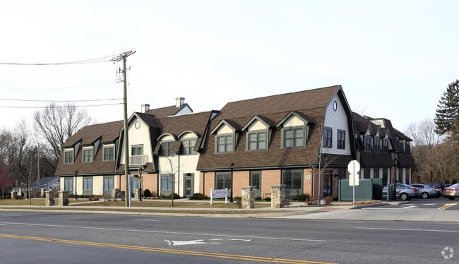
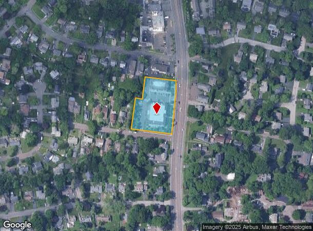
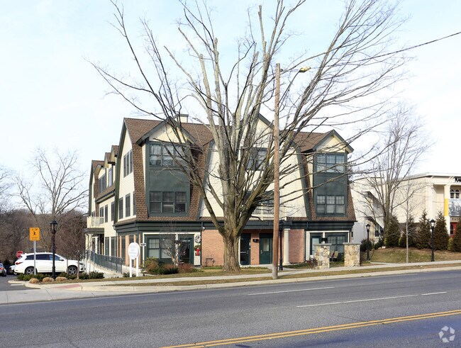
Property Record
816 High Ridge Rd, Stamford, CT 06905
NEARBY LISTINGS FOR SALE OR LEASE
Property Detail
816 High Ridge Rd
STAM-000001-000000-002650
Fairfield
Commercialnec
Connecticut
X
1.49 AC
09001C0244F
Stamford
2024
Westchester/So Connecticut
2025
Bridgeport-Stamford-Norwalk, CT
020600
DEMOGRAPHICS near 816 High Ridge Rd
1 Mile
3 Mile
5 Mile
2024 Total Population
8,641
78,081
197,390
2029 Population
8,629
78,704
198,703
Pop Growth 2024-2029
(0.14%)
+ 0.80%
+ 0.67%
Average Age
43
40
39
2024 Total Households
3,077
30,005
74,867
HH Growth 2024-2029
(0.23%)
+ 0.87%
+ 0.84%
Median Household Inc
$153,673
$119,493
$120,114
Avg Household Size
2.70
2.50
2.50
2024 Avg HH Vehicles
2.00
2.00
2.00
Median Home Value
$728,297
$677,255
$786,843
Median Year Built
1958
1966
1970
Nearby Places
Map Layers
Map Styles
 Street
 Aerial
- Restaurants
- Banks
- Shops
- Fitness
- Groceries
PUBLIC TRANSPORTATION
COMMUTER RAIL
Springdale Station (New Haven Line - Metro-North Commuter Railroad Company (Metro-North))
DRIVE
WALK
Distance
Springdale Station (New Haven Line - Metro-North Commuter Railroad Company (Metro-North))
8 min
2.8 mi
Talmadge Hill Station (New Haven Line - Metro-North Commuter Railroad Company (Metro-North))
DRIVE
WALK
Distance
Talmadge Hill Station (New Haven Line - Metro-North Commuter Railroad Company (Metro-North))
6 min
3.6 mi
AIRPORT
Westchester County
DRIVE
WALK
Distance
Westchester County
24 min
11.8 mi
LaGuardia
DRIVE
WALK
Distance
LaGuardia
50 min
38.6 mi
John F Kennedy International
DRIVE
WALK
Distance
John F Kennedy International
58 min
45.9 mi
Nearby Properties
Address
Land Use
TOTAL SIZE
Lot Size
Zoning
Address
Land Use
TOTAL SIZE
Lot Size
Zoning
13.21 AC
CSCD
Address
Land Use
TOTAL SIZE
Lot Size
Zoning
9.62 AC
MZN
Address
Land Use
TOTAL SIZE
Lot Size
Zoning
377,754 SF
2.06 AC
PD
Address
Land Use
TOTAL SIZE
Lot Size
Zoning
377,918 SF
22.42 AC
MZN
Address
Land Use
TOTAL SIZE
Lot Size
Zoning
304,345 SF
1.15 AC
PD
Address
Land Use
TOTAL SIZE
Lot Size
Zoning
3.14 AC
RH
Address
Land Use
TOTAL SIZE
Lot Size
Zoning
243,000 SF
3.02 AC
CG
Address
Land Use
TOTAL SIZE
Lot Size
Zoning
334,905 SF
2.52 AC
MXD
Address
Land Use
TOTAL SIZE
Lot Size
Zoning
32.43 AC
RA1
Address
Land Use
TOTAL SIZE
Lot Size
Zoning
4.53 AC
RH
Address
Land Use
TOTAL SIZE
Lot Size
Zoning
25.91 AC
MZN
Address
Land Use
TOTAL SIZE
Lot Size
Zoning
322,812 SF
3.17 AC
MZN
Address
Land Use
TOTAL SIZE
Lot Size
Zoning
229,644 SF
3.12 AC
RH
Address
Land Use
TOTAL SIZE
Lot Size
Zoning
29.87 AC
R10
Address
Land Use
TOTAL SIZE
Lot Size
Zoning
236,713 SF
3.21 AC
RMF
Address
Land Use
TOTAL SIZE
Lot Size
Zoning
234,344 SF
3.24 AC
RH
Address
Land Use
TOTAL SIZE
Lot Size
Zoning
13.56 AC
R75
Address
Land Use
TOTAL SIZE
Lot Size
Zoning
272,801 SF
4.32 AC
MZN
Address
Land Use
TOTAL SIZE
Lot Size
Zoning
3.59 AC
RH
Address
Land Use
TOTAL SIZE
Lot Size
Zoning
76.36 AC
2AC
Address
Land Use
TOTAL SIZE
Lot Size
Zoning
26.11 AC
CN
Address
Land Use
TOTAL SIZE
Lot Size
Zoning
92,870 SF
2.08 AC
RMF
Address
Land Use
TOTAL SIZE
Lot Size
Zoning
75,531 SF
6.85 AC
MZN
Address
Land Use
TOTAL SIZE
Lot Size
Zoning
277,836 SF
2.17 AC
CB
Address
Land Use
TOTAL SIZE
Lot Size
Zoning
189,804 SF
1.54 AC
MXD
Address
Land Use
TOTAL SIZE
Lot Size
Zoning
34.05 AC
RA1
Address
Land Use
TOTAL SIZE
Lot Size
Zoning
16.99 AC
CD
Address
Land Use
TOTAL SIZE
Lot Size
Zoning
28.54 AC
R20
Address
Land Use
TOTAL SIZE
Lot Size
Zoning
10.84 AC
R75
Address
Land Use
TOTAL SIZE
Lot Size
Zoning
173,641 SF
2.41 AC
RH
The World's #1 Commercial Real Estate Marketplace
Connect with us
© 2026 CoStar Group
The information above has been obtained from sources believed reliable. While we do not doubt its accuracy we have not verified it and make no guarantee, warranty or representation about it. It is your responsibility to independently confirm its accuracy and completeness. Any projections, opinions, assumptions, or estimates used are for example only and do not represent the current or future performance of the property. The value of this transaction to you depends on tax and other factors which should be evaluated by your tax, financial, and legal advisors. You and your advisors should conduct a careful, independent investigation of the property to determine to your satisfaction the suitability of the property for your needs.