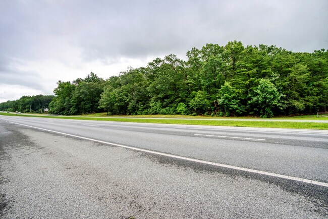
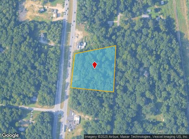
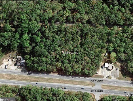
Property Record
8160 Crain Hwy, La Plata, MD 20646

NEARBY LISTINGS FOR SALE OR LEASE
Property Detail
8160 Crain Hwy
Washington-Arlington-Alexandria, DC-VA-MD-WV
Town Of La Plata
01-007149
3.40 AC RT 301 N FAIR GRO RD
Commercialnec
Charles
X
Maryland
24017C0330C
3.40 AC
0
Charles County
2025
Washington, DC
851001
DEMOGRAPHICS near 8160 Crain Hwy
1 Mile
3 Mile
5 Mile
2024 Total Population
494
9,039
20,568
2029 Population
508
9,451
21,517
Pop Growth 2024-2029
+ 2.83%
+ 4.56%
+ 4.61%
Average Age
43
41
41
2024 Total Households
179
3,271
7,409
HH Growth 2024-2029
+ 3.35%
+ 4.59%
+ 4.64%
Median Household Inc
$156,667
$117,643
$116,806
Avg Household Size
2.80
2.70
2.70
2024 Avg HH Vehicles
3.00
2.00
2.00
Median Home Value
$551,724
$398,097
$420,180
Median Year Built
1977
1985
1988
Nearby Places
Map Layers
Map Styles
 Street
 Aerial
- Restaurants
- Banks
- Shops
- Fitness
- Groceries
PUBLIC TRANSPORTATION
AIRPORT
Ronald Reagan Washington Ntl
DRIVE
WALK
Distance
Ronald Reagan Washington Ntl
62 min
38.3 mi
Freight Ports
Port of Baltimore
DRIVE
WALK
Distance
Port of Baltimore
97 min
65.2 mi
SALE & LEASE HISTORY
LISTING DATE
SALE/LEASE

Aug 14, 2020
For Sale
Nearby Properties
Address
Land Use
TOTAL SIZE
Lot Size
Zoning
Address
Land Use
TOTAL SIZE
Lot Size
Zoning
150,480 SF
4.60 AC
CH
Address
Land Use
TOTAL SIZE
Lot Size
Zoning
6.54 AC
PL
Address
Land Use
TOTAL SIZE
Lot Size
Zoning
106,711 SF
92.18 AC
PL
Address
Land Use
TOTAL SIZE
Lot Size
Zoning
65,890 SF
6.70 AC
PL
Address
Land Use
TOTAL SIZE
Lot Size
Zoning
70,913 SF
6.02 AC
CH
Address
Land Use
TOTAL SIZE
Lot Size
Zoning
89,000 SF
2.13 AC
CB
Address
Land Use
TOTAL SIZE
Lot Size
Zoning
1,350 SF
820.92 AC
RC
Address
Land Use
TOTAL SIZE
Lot Size
Zoning
38,228 SF
21.77 AC
PL
Address
Land Use
TOTAL SIZE
Lot Size
Zoning
39,786 SF
1.53 AC
C-B
Address
Land Use
TOTAL SIZE
Lot Size
Zoning
39,626 SF
4.07 AC
C-H
Address
Land Use
TOTAL SIZE
Lot Size
Zoning
60,244 SF
5.27 AC
MUD-2
Address
Land Use
TOTAL SIZE
Lot Size
Zoning
17,667 SF
2.22 AC
CBT
Address
Land Use
TOTAL SIZE
Lot Size
Zoning
37,900 SF
1 AC
P-L
Address
Land Use
TOTAL SIZE
Lot Size
Zoning
49,919 SF
2.21 AC
CH
Address
Land Use
TOTAL SIZE
Lot Size
Zoning
75,000 SF
16.44 AC
PL
Address
Land Use
TOTAL SIZE
Lot Size
Zoning
33,904 SF
0.96 AC
C-H
Address
Land Use
TOTAL SIZE
Lot Size
Zoning
32,192 SF
0.73 AC
C-B
Address
Land Use
TOTAL SIZE
Lot Size
Zoning
18,952 SF
1.87 AC
CH
Address
Land Use
TOTAL SIZE
Lot Size
Zoning
14,500 SF
4.55 AC
CH
Address
Land Use
TOTAL SIZE
Lot Size
Zoning
72,162 SF
25.34 AC
P-L
Address
Land Use
TOTAL SIZE
Lot Size
Zoning
14,070 SF
7.14 AC
CBT
Address
Land Use
TOTAL SIZE
Lot Size
Zoning
38,040 SF
12.76 AC
CV
Address
Land Use
TOTAL SIZE
Lot Size
Zoning
25,580 SF
0.34 AC
CB
Address
Land Use
TOTAL SIZE
Lot Size
Zoning
15,048 SF
1.69 AC
CH
Address
Land Use
TOTAL SIZE
Lot Size
Zoning
61,933 SF
5.41 AC
CH
Address
Land Use
TOTAL SIZE
Lot Size
Zoning
15,682 SF
1.52 AC
CB
Address
Land Use
TOTAL SIZE
Lot Size
Zoning
2,991 SF
0.69 AC
CH
Address
Land Use
TOTAL SIZE
Lot Size
Zoning
21,598 SF
1.50 AC
CBT
Address
Land Use
TOTAL SIZE
Lot Size
Zoning
17,661 SF
1.23 AC
CB
Address
Land Use
TOTAL SIZE
Lot Size
Zoning
14,814 SF
1.29 AC
CB
The World's #1 Commercial Real Estate Marketplace
Connect with us
© 2025 CoStar Group
The information above has been obtained from sources believed reliable. While we do not doubt its accuracy we have not verified it and make no guarantee, warranty or representation about it. It is your responsibility to independently confirm its accuracy and completeness. Any projections, opinions, assumptions, or estimates used are for example only and do not represent the current or future performance of the property. The value of this transaction to you depends on tax and other factors which should be evaluated by your tax, financial, and legal advisors. You and your advisors should conduct a careful, independent investigation of the property to determine to your satisfaction the suitability of the property for your needs.