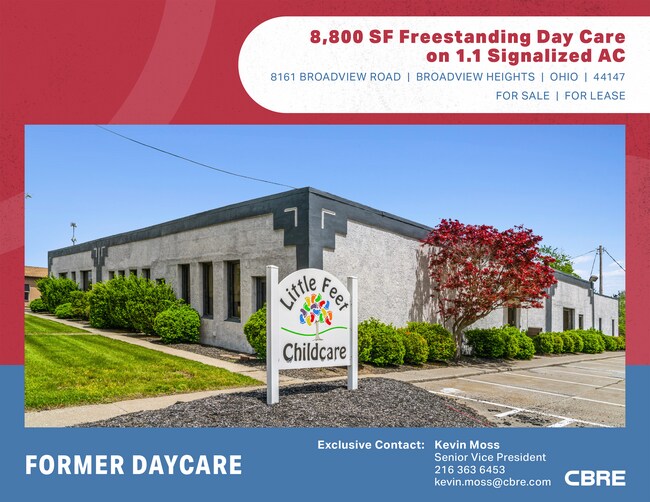
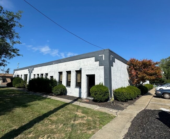
Property Record
8161 Broadview Rd, Broadview Heights, OH 44147

Current Lease Availabilities
Property Detail
8161 Broadview Rd
581-27-006
VOL 365 PG 68 PCL B FF 263.88 D 268.04 1.1045AC OL 6 2012S/R
Daycare
Cuyahoga
C-1
Ohio
B and X Area of moderate flood hazard, usually the area between the limits of the 100-year and 500-year floods.
23
2025
1.11 AC
2025
South
136103
Cleveland
8,677 SF
Cleveland-Elyria, OH
NEARBY LISTINGS FOR SALE OR LEASE
DEMOGRAPHICS near 8161 Broadview Rd
1 mile
3 mile
5 mile
2025 Total Population
5,543
48,247
142,443
2030 Population
5,409
47,367
140,858
Pop Growth 2025-2030
(2.42%)
(1.82%)
(1.11%)
Average Age
45
45
44
2025 Total Households
2,318
19,755
60,373
HH Growth 2025-2030
(2.59%)
(1.98%)
(1.20%)
Median Household Inc
$86,897
$92,820
$80,979
Avg Household Size
2.40
2.40
2.30
2025 Avg HH Vehicles
2.00
2.00
2.00
Median Home Value
$275,237
$270,390
$235,989
Median Year Built
1971
1969
1966
Nearby Places
Map Layers
Map Styles
 Street
 Aerial
Layers
 Traffic
 Biking
Places
Listings with unknown addresses are not visible on the map
- Restaurants
- Banks
- Shops
- Fitness
- Groceries
PUBLIC TRANSPORTATION
COMMUTER RAIL
Canal Exploration Center (National Park Scenic Railway - Cuyahoga Valley Scenic Railroad)
Drive
Walk
Distance
Canal Exploration Center (National Park Scenic Railway - Cuyahoga Valley Scenic Railroad)
11 min
5.6 mi
Rockside (National Park Scenic Railway - Cuyahoga Valley Scenic Railroad)
Drive
Walk
Distance
Rockside (National Park Scenic Railway - Cuyahoga Valley Scenic Railroad)
14 min
7.2 mi
AIRPORT
Cleveland-Hopkins International
Drive
Walk
Distance
Cleveland-Hopkins International
29 min
14.2 mi
Freight Ports
Port of Toledo
Drive
Walk
Distance
Port of Toledo
143 min
115.4 mi
Nearby Properties
Address
Land Use
TOTAL SIZE
Lot Size
Zoning
Address
Land Use
TOTAL SIZE
Lot Size
Zoning
202,152 SF
21.04 AC
U-1
Address
Land Use
TOTAL SIZE
Lot Size
Zoning
238,500 SF
20.89 AC
SC
Address
Land Use
TOTAL SIZE
Lot Size
Zoning
238,500 SF
20.31 AC
SC
Address
Land Use
TOTAL SIZE
Lot Size
Zoning
162,134 SF
12.24 AC
CG
Address
Land Use
TOTAL SIZE
Lot Size
Zoning
285,065 SF
5.43 AC
D-1
Address
Land Use
TOTAL SIZE
Lot Size
Zoning
281,600 SF
18.73 AC
SF-A
Address
Land Use
TOTAL SIZE
Lot Size
Zoning
166,699 SF
65.80 AC
B-5
Address
Land Use
TOTAL SIZE
Lot Size
Zoning
149,522 SF
19.09 AC
PF
Address
Land Use
TOTAL SIZE
Lot Size
Zoning
48,682 SF
4.64 AC
C-4
Address
Land Use
TOTAL SIZE
Lot Size
Zoning
63,282 SF
20.09 AC
O-B
Address
Land Use
TOTAL SIZE
Lot Size
Zoning
28,189 SF
15.33 AC
B-1OR2
Address
Land Use
TOTAL SIZE
Lot Size
Zoning
124,224 SF
25.99 AC
U-1
Address
Land Use
TOTAL SIZE
Lot Size
Zoning
238,500 SF
20.41 AC
SC
Address
Land Use
TOTAL SIZE
Lot Size
Zoning
56,002 SF
6.76 AC
U-5
Address
Land Use
TOTAL SIZE
Lot Size
Zoning
126,224 SF
5.31 AC
RB
Address
Land Use
TOTAL SIZE
Lot Size
Zoning
188,503 SF
23.72 AC
D-1
Address
Land Use
TOTAL SIZE
Lot Size
Zoning
24,900 SF
4.42 AC
B-1OR2
Address
Land Use
TOTAL SIZE
Lot Size
Zoning
55,332 SF
3.01 AC
E-2
Address
Land Use
TOTAL SIZE
Lot Size
Zoning
89,807 SF
7.29 AC
Address
Land Use
TOTAL SIZE
Lot Size
Zoning
49,470 SF
6.61 AC
E-1
Address
Land Use
TOTAL SIZE
Lot Size
Zoning
83,495 SF
9.70 AC
E-1
Address
Land Use
TOTAL SIZE
Lot Size
Zoning
142,510 SF
13.87 AC
E-2
Address
Land Use
TOTAL SIZE
Lot Size
Zoning
59,813 SF
5.56 AC
Address
Land Use
TOTAL SIZE
Lot Size
Zoning
72,957 SF
11.48 AC
1F-3
Address
Land Use
TOTAL SIZE
Lot Size
Zoning
49,388 SF
29.19 AC
C-F
Address
Land Use
TOTAL SIZE
Lot Size
Zoning
49,811 SF
21.80 AC
A-1
Address
Land Use
TOTAL SIZE
Lot Size
Zoning
111,152 SF
80.99 AC
C-F
Address
Land Use
TOTAL SIZE
Lot Size
Zoning
37,452 SF
16.24 AC
D-1
Address
Land Use
TOTAL SIZE
Lot Size
Zoning
123.70 AC
A-1
Address
Land Use
TOTAL SIZE
Lot Size
Zoning
96,600 SF
8.95 AC
MF-1
The World's #1 Commercial Real Estate Marketplace
Connect with us
© 2026 CoStar Group
The information above has been obtained from sources believed reliable. While we do not doubt its accuracy we have not verified it and make no guarantee, warranty or representation about it. It is your responsibility to independently confirm its accuracy and completeness. Any projections, opinions, assumptions, or estimates used are for example only and do not represent the current or future performance of the property. The value of this transaction to you depends on tax and other factors which should be evaluated by your tax, financial, and legal advisors. You and your advisors should conduct a careful, independent investigation of the property to determine to your satisfaction the suitability of the property for your needs.