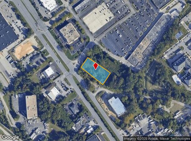
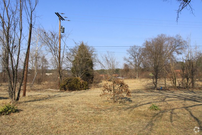
Property Record
8163 Ritchie Hwy, Pasadena, MD 21122

NEARBY LISTINGS FOR SALE OR LEASE
Property Detail
8163 Ritchie Hwy
Baltimore-Columbia-Towson, MD
Elvaton
03-000-14250400
1 ACRE ELVATON
Commercialnec
Anne Arundel
X
Maryland
24003C0155E
2
2024
1 AC
2025
Route 2 Corridor South
731307
Baltimore
842 SF
DEMOGRAPHICS near 8163 Ritchie Hwy
1 Mile
3 Mile
5 Mile
2024 Total Population
6,456
91,987
185,530
2029 Population
6,662
94,101
189,846
Pop Growth 2024-2029
+ 3.19%
+ 2.30%
+ 2.33%
Average Age
40
39
40
2024 Total Households
2,633
34,052
68,245
HH Growth 2024-2029
+ 3.38%
+ 2.37%
+ 2.37%
Median Household Inc
$103,737
$98,955
$105,802
Avg Household Size
2.40
2.60
2.70
2024 Avg HH Vehicles
2.00
2.00
2.00
Median Home Value
$406,909
$387,867
$389,611
Median Year Built
1996
1979
1979
Nearby Places
Map Layers
Map Styles
 Street
 Aerial
- Restaurants
- Banks
- Shops
- Fitness
- Groceries
PUBLIC TRANSPORTATION
AIRPORT
Baltimore/Washington International Thurgood Marshall
DRIVE
WALK
Distance
Baltimore/Washington International Thurgood Marshall
18 min
10.1 mi
Freight Ports
Port of Baltimore
DRIVE
WALK
Distance
Port of Baltimore
25 min
15.6 mi
SALE & LEASE HISTORY
LISTING DATE
SALE/LEASE

Sep 24, 2016
For Sale
Nearby Properties
Address
Land Use
TOTAL SIZE
Lot Size
Zoning
Address
Land Use
TOTAL SIZE
Lot Size
Zoning
637,060 SF
22.19 AC
C2
Address
Land Use
TOTAL SIZE
Lot Size
Zoning
851,355 SF
172.49 AC
R5
Address
Land Use
TOTAL SIZE
Lot Size
Zoning
374,664 SF
22.89 AC
R15
Address
Land Use
TOTAL SIZE
Lot Size
Zoning
32.18 AC
R15
Address
Land Use
TOTAL SIZE
Lot Size
Zoning
176,405 SF
41.81 AC
C3
Address
Land Use
TOTAL SIZE
Lot Size
Zoning
11.57 AC
R22
Address
Land Use
TOTAL SIZE
Lot Size
Zoning
285,360 SF
14.96 AC
Address
Land Use
TOTAL SIZE
Lot Size
Zoning
277,037 SF
10.45 AC
R5
Address
Land Use
TOTAL SIZE
Lot Size
Zoning
14.21 AC
R15
Address
Land Use
TOTAL SIZE
Lot Size
Zoning
15.33 AC
R15
Address
Land Use
TOTAL SIZE
Lot Size
Zoning
21.45 AC
R15
Address
Land Use
TOTAL SIZE
Lot Size
Zoning
14.53 AC
R22
Address
Land Use
TOTAL SIZE
Lot Size
Zoning
14.58 AC
R22
Address
Land Use
TOTAL SIZE
Lot Size
Zoning
16.72 AC
R15
Address
Land Use
TOTAL SIZE
Lot Size
Zoning
7.07 AC
R15
Address
Land Use
TOTAL SIZE
Lot Size
Zoning
18.93 AC
R15
Address
Land Use
TOTAL SIZE
Lot Size
Zoning
154,044 SF
16.89 AC
C3
Address
Land Use
TOTAL SIZE
Lot Size
Zoning
123,376 SF
25.42 AC
C3
Address
Land Use
TOTAL SIZE
Lot Size
Zoning
14.70 AC
R15
Address
Land Use
TOTAL SIZE
Lot Size
Zoning
166,646 SF
4.61 AC
R22
Address
Land Use
TOTAL SIZE
Lot Size
Zoning
303,626 SF
20.88 AC
C3
Address
Land Use
TOTAL SIZE
Lot Size
Zoning
0.34 AC
R22
Address
Land Use
TOTAL SIZE
Lot Size
Zoning
7.64 AC
R15
Address
Land Use
TOTAL SIZE
Lot Size
Zoning
28,188 SF
6.51 AC
C3
Address
Land Use
TOTAL SIZE
Lot Size
Zoning
106,160 SF
5.11 AC
R-2
Address
Land Use
TOTAL SIZE
Lot Size
Zoning
6.95 AC
R15
Address
Land Use
TOTAL SIZE
Lot Size
Zoning
106,760 SF
5.09 AC
C4
Address
Land Use
TOTAL SIZE
Lot Size
Zoning
139,230 SF
39.22 AC
R2
Address
Land Use
TOTAL SIZE
Lot Size
Zoning
122,175 SF
7.32 AC
R5
Address
Land Use
TOTAL SIZE
Lot Size
Zoning
154,056 SF
19.89 AC
R2
The World's #1 Commercial Real Estate Marketplace
Connect with us
© 2025 CoStar Group
The information above has been obtained from sources believed reliable. While we do not doubt its accuracy we have not verified it and make no guarantee, warranty or representation about it. It is your responsibility to independently confirm its accuracy and completeness. Any projections, opinions, assumptions, or estimates used are for example only and do not represent the current or future performance of the property. The value of this transaction to you depends on tax and other factors which should be evaluated by your tax, financial, and legal advisors. You and your advisors should conduct a careful, independent investigation of the property to determine to your satisfaction the suitability of the property for your needs.