Property Record
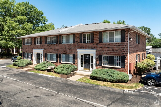
8166 Grant Colonial Dr, Saint Louis, MO 63123

NEARBY LISTINGS FOR SALE OR LEASE
-
-
View all Saint Louis listings for sale on LoopNet.com
Property Detail
8166 Grant Colonial Dr
24K-22-0055
LOC EAST OF N-S CENTER LINE OF SECTION
Apartment
St. Louis
X
Missouri
29189C0329K
4.66 AC
2024
Marlborough
2025
St. Louis
220801
St. Louis, MO-IL
181,253 SF
DEMOGRAPHICS near 8166 Grant Colonial Dr
1 Mile
3 Mile
5 Mile
2024 Total Population
12,988
106,673
279,370
2029 Population
12,571
103,572
269,247
Pop Growth 2024-2029
(3.21%)
(2.91%)
(3.62%)
Average Age
44
42
42
2024 Total Households
6,321
46,358
125,715
HH Growth 2024-2029
(3.43%)
(3.13%)
(3.81%)
Median Household Inc
$71,427
$80,510
$73,069
Avg Household Size
2.00
2.20
2.20
2024 Avg HH Vehicles
2.00
2.00
2.00
Median Home Value
$276,452
$253,092
$238,271
Median Year Built
1963
1957
1955
Nearby Places
Map Layers
Map Styles
 Street
 Aerial
- Restaurants
- Banks
- Shops
- Fitness
- Groceries
PUBLIC TRANSPORTATION
COMMUTER RAIL
Shrewsbury-Lansdowne (Shrewsbury-Lansdowne I-44 Emerson Park - St. Louis MetroLink (MetroLink))
DRIVE
WALK
Distance
Shrewsbury-Lansdowne (Shrewsbury-Lansdowne I-44 Emerson Park - St. Louis MetroLink (MetroLink))
6 min
2.9 mi
Sunnen (Shrewsbury-Lansdowne I-44 Emerson Park - St. Louis MetroLink (MetroLink))
DRIVE
WALK
Distance
Sunnen (Shrewsbury-Lansdowne I-44 Emerson Park - St. Louis MetroLink (MetroLink))
6 min
3.3 mi
AIRPORT
St Louis Lambert International
DRIVE
WALK
Distance
St Louis Lambert International
24 min
15.4 mi
Scott AFB/Midamerica St Louis
DRIVE
WALK
Distance
Scott AFB/Midamerica St Louis
55 min
36.1 mi
Freight Ports
Port Milwaukee
DRIVE
WALK
Distance
Port Milwaukee
434 min
380.4 mi
Nearby Properties
Address
Land Use
TOTAL SIZE
Lot Size
Zoning
Address
Land Use
TOTAL SIZE
Lot Size
Zoning
844,350 SF
63.08 AC
64A1
Address
Land Use
TOTAL SIZE
Lot Size
Zoning
57.77 AC
A
Address
Land Use
TOTAL SIZE
Lot Size
Zoning
559,752 SF
24.37 AC
53R-3
Address
Land Use
TOTAL SIZE
Lot Size
Zoning
322,742 SF
15.04 AC
9LID
Address
Land Use
TOTAL SIZE
Lot Size
Zoning
389,475 SF
27.55 AC
D
Address
Land Use
TOTAL SIZE
Lot Size
Zoning
142,232 SF
28.76 AC
NU
Address
Land Use
TOTAL SIZE
Lot Size
Zoning
212,406 SF
21.42 AC
AB
Address
Land Use
TOTAL SIZE
Lot Size
Zoning
198,556 SF
10.12 AC
A
Address
Land Use
TOTAL SIZE
Lot Size
Zoning
44.38 AC
R1
Address
Land Use
TOTAL SIZE
Lot Size
Zoning
158,767 SF
17.01 AC
64A3
Address
Land Use
TOTAL SIZE
Lot Size
Zoning
39,712 SF
30.49 AC
R1
Address
Land Use
TOTAL SIZE
Lot Size
Zoning
3,024 SF
4.73 AC
64A3
Address
Land Use
TOTAL SIZE
Lot Size
Zoning
8,981 SF
10.81 AC
64A3
Address
Land Use
TOTAL SIZE
Lot Size
Zoning
22.44 AC
A
Address
Land Use
TOTAL SIZE
Lot Size
Zoning
396 SF
8.57 AC
69M-1
Address
Land Use
TOTAL SIZE
Lot Size
Zoning
48,236 SF
16.23 AC
64A1
Address
Land Use
TOTAL SIZE
Lot Size
Zoning
1,176 SF
11.19 AC
64A3
Address
Land Use
TOTAL SIZE
Lot Size
Zoning
375,783 SF
15.42 AC
37MULTI
Address
Land Use
TOTAL SIZE
Lot Size
Zoning
1,512 SF
23.22 AC
41SP
Address
Land Use
TOTAL SIZE
Lot Size
Zoning
113,971 SF
6.64 AC
C-8
Address
Land Use
TOTAL SIZE
Lot Size
Zoning
142,800 SF
13.38 AC
106PL1
Address
Land Use
TOTAL SIZE
Lot Size
Zoning
22.67 AC
PCD
Address
Land Use
TOTAL SIZE
Lot Size
Zoning
262,264 SF
16.27 AC
R6
Address
Land Use
TOTAL SIZE
Lot Size
Zoning
106,148 SF
13.01 AC
53C-2
Address
Land Use
TOTAL SIZE
Lot Size
Zoning
2,369 SF
10.70 AC
R4
Address
Land Use
TOTAL SIZE
Lot Size
Zoning
489,909 SF
20.11 AC
R4
Address
Land Use
TOTAL SIZE
Lot Size
Zoning
1,800 SF
116.73 AC
PS
Address
Land Use
TOTAL SIZE
Lot Size
Zoning
261,362 SF
17.19 AC
R6
Address
Land Use
TOTAL SIZE
Lot Size
Zoning
17.92 AC
64A4
Address
Land Use
TOTAL SIZE
Lot Size
Zoning
36,112 SF
84.29 AC
AA
The World's #1 Commercial Real Estate Marketplace
Connect with us
© 2025 CoStar Group
The information above has been obtained from sources believed reliable. While we do not doubt its accuracy we have not verified it and make no guarantee, warranty or representation about it. It is your responsibility to independently confirm its accuracy and completeness. Any projections, opinions, assumptions, or estimates used are for example only and do not represent the current or future performance of the property. The value of this transaction to you depends on tax and other factors which should be evaluated by your tax, financial, and legal advisors. You and your advisors should conduct a careful, independent investigation of the property to determine to your satisfaction the suitability of the property for your needs.