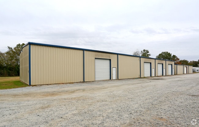
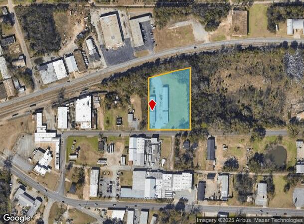
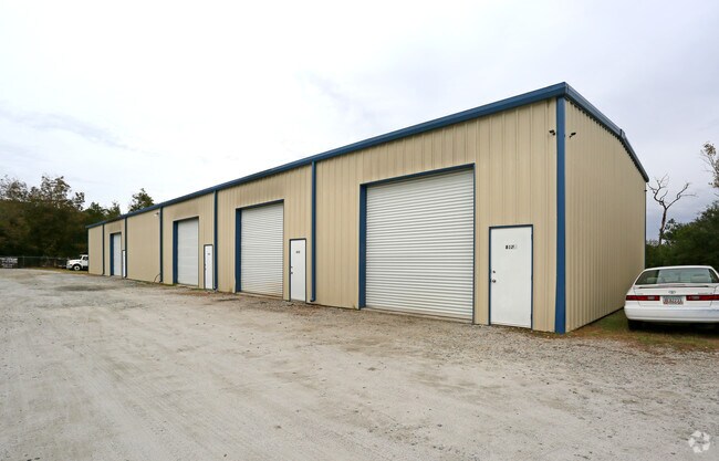
Property Record
817 Flint Ave, Albany, GA 31701
NEARBY LISTINGS FOR SALE OR LEASE
-
-
-
-
No Photo
-
-
-
-
View all Albany listings for sale on LoopNet.com
Property Detail
817 Flint Ave
Albany, GA
Roosevelt Ave Downtown
0000D-00033-08D
LOTS 3-6 FLINT AVE COMMERCIAL PARK
Publicstorage
Dougherty
X
Georgia
13095C0108E
3-6
2024
2.46 AC
2024
Albany/Southwest
011400
Other Market Areas
6,125 SF
DEMOGRAPHICS near 817 Flint Ave
1 Mile
3 Mile
5 Mile
2024 Total Population
6,696
40,089
73,118
2029 Population
6,569
38,394
70,762
Pop Growth 2024-2029
(1.90%)
(4.23%)
(3.22%)
Average Age
39
38
38
2024 Total Households
3,021
16,953
30,220
HH Growth 2024-2029
(2.02%)
(4.32%)
(3.42%)
Median Household Inc
$28,705
$37,728
$43,126
Avg Household Size
2.20
2.20
2.30
2024 Avg HH Vehicles
1.00
1.00
1.00
Median Home Value
$70,700
$86,566
$123,046
Median Year Built
1955
1968
1975
Nearby Places
Map Layers
Map Styles
 Street
 Aerial
- Restaurants
- Banks
- Shops
- Fitness
- Groceries
PUBLIC TRANSPORTATION
AIRPORT
Southwest Georgia Regional
DRIVE
WALK
Distance
Southwest Georgia Regional
10 min
4.5 mi
Freight Ports
Port of Panama City
DRIVE
WALK
Distance
Port of Panama City
230 min
158.8 mi
Nearby Properties
Address
Land Use
TOTAL SIZE
Lot Size
Zoning
Address
Land Use
TOTAL SIZE
Lot Size
Zoning
Address
Land Use
TOTAL SIZE
Lot Size
Zoning
58.86 AC
C3
Address
Land Use
TOTAL SIZE
Lot Size
Zoning
51,008 SF
19.48 AC
C5
Address
Land Use
TOTAL SIZE
Lot Size
Zoning
274,484 SF
16.31 AC
C5
Address
Land Use
TOTAL SIZE
Lot Size
Zoning
1.77 AC
C2
Address
Land Use
TOTAL SIZE
Lot Size
Zoning
15.20 AC
C2
Address
Land Use
TOTAL SIZE
Lot Size
Zoning
2.53 AC
C2
Address
Land Use
TOTAL SIZE
Lot Size
Zoning
1.75 AC
C2
Address
Land Use
TOTAL SIZE
Lot Size
Zoning
0.83 AC
C2
Address
Land Use
TOTAL SIZE
Lot Size
Zoning
77,688 SF
2.93 AC
C3
Address
Land Use
TOTAL SIZE
Lot Size
Zoning
70,596 SF
2.38 AC
C2
Address
Land Use
TOTAL SIZE
Lot Size
Zoning
232,840 SF
49.88 AC
M1
Address
Land Use
TOTAL SIZE
Lot Size
Zoning
0.54 AC
C2
Address
Land Use
TOTAL SIZE
Lot Size
Zoning
9,676 SF
10.73 AC
R6
Address
Land Use
TOTAL SIZE
Lot Size
Zoning
9.37 AC
C3
Address
Land Use
TOTAL SIZE
Lot Size
Zoning
21,144 SF
11.79 AC
R6
Address
Land Use
TOTAL SIZE
Lot Size
Zoning
19,104 SF
10.81 AC
R6
Address
Land Use
TOTAL SIZE
Lot Size
Zoning
8 AC
M1
Address
Land Use
TOTAL SIZE
Lot Size
Zoning
204,625 SF
27.28 AC
M1
Address
Land Use
TOTAL SIZE
Lot Size
Zoning
0.52 AC
C2
Address
Land Use
TOTAL SIZE
Lot Size
Zoning
98,560 SF
19.64 AC
R6
Address
Land Use
TOTAL SIZE
Lot Size
Zoning
82,944 SF
8.10 AC
R6
Address
Land Use
TOTAL SIZE
Lot Size
Zoning
25,777 SF
9.30 AC
C3
Address
Land Use
TOTAL SIZE
Lot Size
Zoning
30,190 SF
212.69 AC
C5
Address
Land Use
TOTAL SIZE
Lot Size
Zoning
28,713 SF
9.96 AC
C3
Address
Land Use
TOTAL SIZE
Lot Size
Zoning
30,336 SF
19.19 AC
R6
Address
Land Use
TOTAL SIZE
Lot Size
Zoning
21,572 SF
5.27 AC
C1
Address
Land Use
TOTAL SIZE
Lot Size
Zoning
5,100 SF
18.93 AC
R6
Address
Land Use
TOTAL SIZE
Lot Size
Zoning
146,281 SF
17.87 AC
M1
Address
Land Use
TOTAL SIZE
Lot Size
Zoning
10,608 SF
45.66 AC
M1
The World's #1 Commercial Real Estate Marketplace
Connect with us
© 2025 CoStar Group
The information above has been obtained from sources believed reliable. While we do not doubt its accuracy we have not verified it and make no guarantee, warranty or representation about it. It is your responsibility to independently confirm its accuracy and completeness. Any projections, opinions, assumptions, or estimates used are for example only and do not represent the current or future performance of the property. The value of this transaction to you depends on tax and other factors which should be evaluated by your tax, financial, and legal advisors. You and your advisors should conduct a careful, independent investigation of the property to determine to your satisfaction the suitability of the property for your needs.