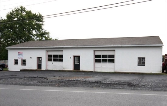
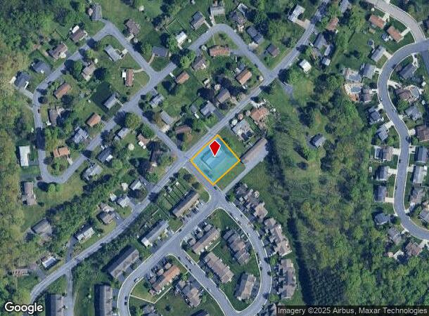
Property Record
817 Magaro Rd, Enola, PA 17025

NEARBY LISTINGS FOR SALE OR LEASE
-
-
View all Enola listings for sale on LoopNet.com
Property Detail
817 Magaro Rd
Harrisburg-Carlisle, PA
SHERWOOD COURT LOT 1-A PB 77 PG 102
09-15-1288-001
Cumberland
Commercialbuilding
Pennsylvania
X
1
42041C0115F
0.45 AC
2025
Harrisburg Area West
2025
Philadelphia
010204
DEMOGRAPHICS near 817 Magaro Rd
1 Mile
3 Mile
5 Mile
2024 Total Population
7,539
50,571
140,086
2029 Population
8,080
54,023
148,456
Pop Growth 2024-2029
+ 7.18%
+ 6.83%
+ 5.97%
Average Age
43
42
40
2024 Total Households
3,014
20,687
58,941
HH Growth 2024-2029
+ 7.50%
+ 7.07%
+ 6.16%
Median Household Inc
$103,131
$95,573
$76,824
Avg Household Size
2.40
2.40
2.30
2024 Avg HH Vehicles
2.00
2.00
2.00
Median Home Value
$259,413
$259,604
$229,340
Median Year Built
1993
1980
1969
Nearby Places
Map Layers
Map Styles
 Street
 Aerial
- Restaurants
- Banks
- Shops
- Fitness
- Groceries
PUBLIC TRANSPORTATION
COMMUTER RAIL
DRIVE
WALK
Distance
12 min
6.1 mi
AIRPORT
Harrisburg International
DRIVE
WALK
Distance
Harrisburg International
29 min
16.6 mi
Nearby Properties
Address
Land Use
TOTAL SIZE
Lot Size
Zoning
Address
Land Use
TOTAL SIZE
Lot Size
Zoning
43.94 AC
Address
Land Use
TOTAL SIZE
Lot Size
Zoning
22.15 AC
Address
Land Use
TOTAL SIZE
Lot Size
Zoning
72.78 AC
Address
Land Use
TOTAL SIZE
Lot Size
Zoning
Address
Land Use
TOTAL SIZE
Lot Size
Zoning
35.15 AC
Address
Land Use
TOTAL SIZE
Lot Size
Zoning
Address
Land Use
TOTAL SIZE
Lot Size
Zoning
69.46 AC
Address
Land Use
TOTAL SIZE
Lot Size
Zoning
Address
Land Use
TOTAL SIZE
Lot Size
Zoning
Address
Land Use
TOTAL SIZE
Lot Size
Zoning
28.13 AC
Address
Land Use
TOTAL SIZE
Lot Size
Zoning
30.87 AC
Address
Land Use
TOTAL SIZE
Lot Size
Zoning
Address
Land Use
TOTAL SIZE
Lot Size
Zoning
725 SF
19.33 AC
Address
Land Use
TOTAL SIZE
Lot Size
Zoning
27.92 AC
Address
Land Use
TOTAL SIZE
Lot Size
Zoning
21.68 AC
Address
Land Use
TOTAL SIZE
Lot Size
Zoning
79.43 AC
Address
Land Use
TOTAL SIZE
Lot Size
Zoning
13.57 AC
Address
Land Use
TOTAL SIZE
Lot Size
Zoning
Address
Land Use
TOTAL SIZE
Lot Size
Zoning
13.05 AC
Address
Land Use
TOTAL SIZE
Lot Size
Zoning
13.25 AC
Address
Land Use
TOTAL SIZE
Lot Size
Zoning
17.48 AC
Address
Land Use
TOTAL SIZE
Lot Size
Zoning
4.41 AC
Address
Land Use
TOTAL SIZE
Lot Size
Zoning
Address
Land Use
TOTAL SIZE
Lot Size
Zoning
5.25 AC
Address
Land Use
TOTAL SIZE
Lot Size
Zoning
10.50 AC
Address
Land Use
TOTAL SIZE
Lot Size
Zoning
16.61 AC
Address
Land Use
TOTAL SIZE
Lot Size
Zoning
14.76 AC
Address
Land Use
TOTAL SIZE
Lot Size
Zoning
15.58 AC
Address
Land Use
TOTAL SIZE
Lot Size
Zoning
1.86 AC
Address
Land Use
TOTAL SIZE
Lot Size
Zoning
4.44 AC
The World's #1 Commercial Real Estate Marketplace
Connect with us
© 2025 CoStar Group
The information above has been obtained from sources believed reliable. While we do not doubt its accuracy we have not verified it and make no guarantee, warranty or representation about it. It is your responsibility to independently confirm its accuracy and completeness. Any projections, opinions, assumptions, or estimates used are for example only and do not represent the current or future performance of the property. The value of this transaction to you depends on tax and other factors which should be evaluated by your tax, financial, and legal advisors. You and your advisors should conduct a careful, independent investigation of the property to determine to your satisfaction the suitability of the property for your needs.