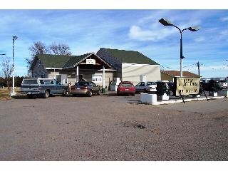
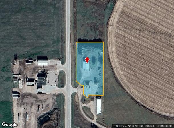
Property Record
817 N Spur 56C Rd, Hershey, NE 69143
NEARBY LISTINGS FOR SALE OR LEASE
-
-
View all Hershey listings for sale on LoopNet.com
Property Detail
817 N Spur 56C Rd
0082583.00
Kj's Replat (Hershey)
Officebuilding
KJ'S REPLAT (OF BOGGS ADM SUB LOTS 1 & 2) LOT 1 3.38 A.; MAP NUMBER: 2873-33-0-00000-000-2512
A
Lincoln
31111C0570C
Nebraska
2024
3.38 AC
2025
I-80 Corridor
959800
Other Market Areas
768 SF
North Platte, NE
DEMOGRAPHICS near 817 N Spur 56C Rd
1 Mile
3 Mile
5 Mile
2024 Total Population
148
930
1,267
2029 Population
145
883
1,205
Pop Growth 2024-2029
(2.03%)
(5.05%)
(4.89%)
Average Age
44
42
43
2024 Total Households
61
389
527
HH Growth 2024-2029
(3.28%)
(5.14%)
(4.74%)
Median Household Inc
$86,250
$71,612
$73,571
Avg Household Size
2.40
2.40
2.40
2024 Avg HH Vehicles
3.00
3.00
3.00
Median Home Value
$244,444
$210,366
$211,504
Median Year Built
1973
1969
1969
Nearby Places
Map Layers
Map Styles
 Street
 Aerial
- Restaurants
- Banks
- Shops
- Fitness
- Groceries
Nearby Properties
Address
Land Use
TOTAL SIZE
Lot Size
Zoning
Address
Land Use
TOTAL SIZE
Lot Size
Zoning
53,000 SF
34.28 AC
COMMERCIAL
Address
Land Use
TOTAL SIZE
Lot Size
Zoning
4,500 SF
8.28 AC
COMMERCIAL
Address
Land Use
TOTAL SIZE
Lot Size
Zoning
320 AC
AGRICULTUR
Address
Land Use
TOTAL SIZE
Lot Size
Zoning
168 SF
156.85 AC
AGRICULTUR
Address
Land Use
TOTAL SIZE
Lot Size
Zoning
298.12 AC
AGRICULTUR
Address
Land Use
TOTAL SIZE
Lot Size
Zoning
10,668 SF
9.29 AC
COMMERCIAL
Address
Land Use
TOTAL SIZE
Lot Size
Zoning
245.19 AC
AGRICULTUR
Address
Land Use
TOTAL SIZE
Lot Size
Zoning
631.87 AC
AGRICULTUR
Address
Land Use
TOTAL SIZE
Lot Size
Zoning
149.54 AC
AGRICULTUR
Address
Land Use
TOTAL SIZE
Lot Size
Zoning
150.92 AC
AGRICULTUR
Address
Land Use
TOTAL SIZE
Lot Size
Zoning
150.10 AC
AGRICULTUR
Address
Land Use
TOTAL SIZE
Lot Size
Zoning
1,200 SF
160 AC
AGRICULTUR
Address
Land Use
TOTAL SIZE
Lot Size
Zoning
160 AC
AGRICULTUR
Address
Land Use
TOTAL SIZE
Lot Size
Zoning
160 AC
AGRICULTUR
Address
Land Use
TOTAL SIZE
Lot Size
Zoning
162.07 AC
AGRICULTUR
Address
Land Use
TOTAL SIZE
Lot Size
Zoning
160.69 AC
AGRICULTUR
Address
Land Use
TOTAL SIZE
Lot Size
Zoning
160 AC
AGRICULTUR
Address
Land Use
TOTAL SIZE
Lot Size
Zoning
165.30 AC
AGRICULTUR
Address
Land Use
TOTAL SIZE
Lot Size
Zoning
157.23 AC
AGRICULTUR
Address
Land Use
TOTAL SIZE
Lot Size
Zoning
139.36 AC
AGRICULTUR
Address
Land Use
TOTAL SIZE
Lot Size
Zoning
142.31 AC
AGRICULTUR
Address
Land Use
TOTAL SIZE
Lot Size
Zoning
7,592 SF
0.21 AC
COMMERCIAL
Address
Land Use
TOTAL SIZE
Lot Size
Zoning
120 AC
AGRICULTUR
Address
Land Use
TOTAL SIZE
Lot Size
Zoning
69.15 AC
AGRICULTUR
Address
Land Use
TOTAL SIZE
Lot Size
Zoning
79 AC
AGRICULTUR
Address
Land Use
TOTAL SIZE
Lot Size
Zoning
160 AC
AGRICULTUR
Address
Land Use
TOTAL SIZE
Lot Size
Zoning
160 AC
AGRICULTUR
Address
Land Use
TOTAL SIZE
Lot Size
Zoning
667 SF
140.75 AC
AGRICULTUR
Address
Land Use
TOTAL SIZE
Lot Size
Zoning
79 AC
AGRICULTUR
The World's #1 Commercial Real Estate Marketplace
Connect with us
© 2025 CoStar Group
The information above has been obtained from sources believed reliable. While we do not doubt its accuracy we have not verified it and make no guarantee, warranty or representation about it. It is your responsibility to independently confirm its accuracy and completeness. Any projections, opinions, assumptions, or estimates used are for example only and do not represent the current or future performance of the property. The value of this transaction to you depends on tax and other factors which should be evaluated by your tax, financial, and legal advisors. You and your advisors should conduct a careful, independent investigation of the property to determine to your satisfaction the suitability of the property for your needs.