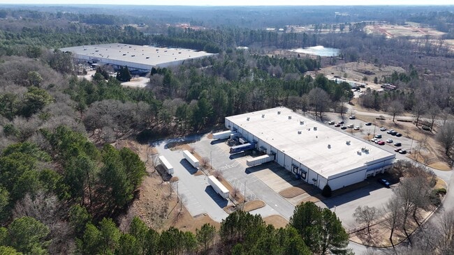
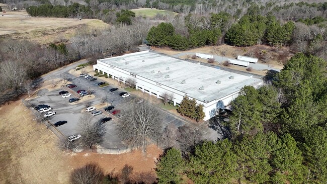
Property Record
815 Progress Dr, Winder, GA 30680

Property Detail
815 Progress Dr
XX043-005
815 PROGRESS DR
Warehouse
Barrow
M-2
Georgia
B and X Area of moderate flood hazard, usually the area between the limits of the 100-year and 500-year floods.
res
2025
19.22 AC
2025
S Barrow
180108
Atlanta
49,527 SF
Atlanta-Sandy Springs-Roswell, GA
NEARBY LISTINGS FOR SALE OR LEASE
DEMOGRAPHICS near 815 Progress Dr
1 mile
3 mile
5 mile
2025 Total Population
319
18,851
58,480
2030 Population
348
20,871
64,592
Pop Growth 2025-2030
+ 9.09%
+ 10.72%
+ 10.45%
Average Age
37
36
37
2025 Total Households
107
6,033
18,744
HH Growth 2025-2030
+ 9.35%
+ 10.91%
+ 10.72%
Median Household Inc
$99,999
$90,812
$86,568
Avg Household Size
3.00
3.10
3.10
2025 Avg HH Vehicles
2.00
2.00
2.00
Median Home Value
$305,556
$336,548
$347,131
Median Year Built
1997
2003
2002
Nearby Places
Map Layers
Map Styles
 Street
 Aerial
Layers
 Traffic
 Biking
Places
Listings with unknown addresses are not visible on the map
- Restaurants
- Banks
- Shops
- Fitness
- Groceries
SALE & LEASE HISTORY
LISTING DATE
SALE/LEASE

Feb 11, 2025
For Lease
Feb 11, 2025
For Sale
Nearby Properties
Address
Land Use
TOTAL SIZE
Lot Size
Zoning
Address
Land Use
TOTAL SIZE
Lot Size
Zoning
222,481 SF
23.21 AC
M-1
Address
Land Use
TOTAL SIZE
Lot Size
Zoning
10,128 SF
28.19 AC
R-3
Address
Land Use
TOTAL SIZE
Lot Size
Zoning
420,876 SF
26.84 AC
M-2
Address
Land Use
TOTAL SIZE
Lot Size
Zoning
164,877 SF
34.89 AC
C1
Address
Land Use
TOTAL SIZE
Lot Size
Zoning
22,320 SF
15.90 AC
R-3
Address
Land Use
TOTAL SIZE
Lot Size
Zoning
120,000 SF
142.73 AC
AG
Address
Land Use
TOTAL SIZE
Lot Size
Zoning
305,327 SF
22.05 AC
M-2
Address
Land Use
TOTAL SIZE
Lot Size
Zoning
301,200 SF
39.18 AC
M-2
Address
Land Use
TOTAL SIZE
Lot Size
Zoning
231,285 SF
34.50 AC
M-2
Address
Land Use
TOTAL SIZE
Lot Size
Zoning
167,580 SF
21.82 AC
M-2
Address
Land Use
TOTAL SIZE
Lot Size
Zoning
183,060 SF
17.90 AC
M-2
Address
Land Use
TOTAL SIZE
Lot Size
Zoning
89,520 SF
13.99 AC
M-2
Address
Land Use
TOTAL SIZE
Lot Size
Zoning
23,546 SF
24.55 AC
RA200
Address
Land Use
TOTAL SIZE
Lot Size
Zoning
137,200 SF
20 AC
M-2
Address
Land Use
TOTAL SIZE
Lot Size
Zoning
2,398 SF
8.13 AC
R-3
Address
Land Use
TOTAL SIZE
Lot Size
Zoning
1,188 SF
7.63 AC
R-3
Address
Land Use
TOTAL SIZE
Lot Size
Zoning
64,800 SF
47.27 AC
M-1
Address
Land Use
TOTAL SIZE
Lot Size
Zoning
20,660 SF
10.94 AC
RA200
Address
Land Use
TOTAL SIZE
Lot Size
Zoning
38,550 SF
3.04 AC
C-2
Address
Land Use
TOTAL SIZE
Lot Size
Zoning
15,808 SF
16.43 AC
RA200
Address
Land Use
TOTAL SIZE
Lot Size
Zoning
105.99 AC
C-3
Address
Land Use
TOTAL SIZE
Lot Size
Zoning
16,384 SF
5.10 AC
RA200
Address
Land Use
TOTAL SIZE
Lot Size
Zoning
69,285 SF
53.11 AC
M-2
Address
Land Use
TOTAL SIZE
Lot Size
Zoning
212.21 AC
RA200
Address
Land Use
TOTAL SIZE
Lot Size
Zoning
153 AC
R100
Address
Land Use
TOTAL SIZE
Lot Size
Zoning
1,036 SF
120.72 AC
C1
Address
Land Use
TOTAL SIZE
Lot Size
Zoning
14,300 SF
5.77 AC
M-1
Address
Land Use
TOTAL SIZE
Lot Size
Zoning
71,300 SF
13.82 AC
M-2
Address
Land Use
TOTAL SIZE
Lot Size
Zoning
24,400 SF
20 AC
M-2
Address
Land Use
TOTAL SIZE
Lot Size
Zoning
166.81 AC
RA200
The World's #1 Commercial Real Estate Marketplace
Connect with us
© 2026 CoStar Group
The information above has been obtained from sources believed reliable. While we do not doubt its accuracy we have not verified it and make no guarantee, warranty or representation about it. It is your responsibility to independently confirm its accuracy and completeness. Any projections, opinions, assumptions, or estimates used are for example only and do not represent the current or future performance of the property. The value of this transaction to you depends on tax and other factors which should be evaluated by your tax, financial, and legal advisors. You and your advisors should conduct a careful, independent investigation of the property to determine to your satisfaction the suitability of the property for your needs.