Property Record
817 Watsontown Rd, Berlin, NJ 08009
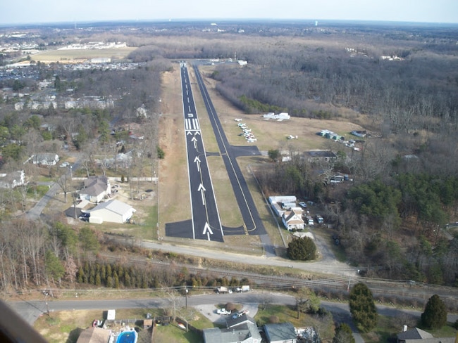
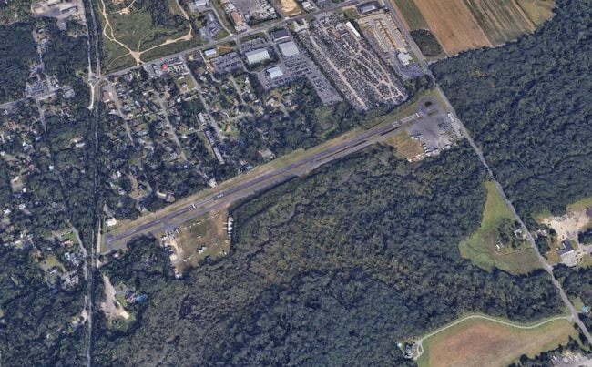
This Property Is For Sale
NEARBY LISTINGS FOR SALE OR LEASE
-
-
View all Berlin listings for sale on LoopNet.com
Property Detail
817 Watsontown Rd
36-00101-0000-00007
FACILITY NAME: AIRPORT
Commercialnec
Camden
A
New Jersey
34007C0139E
7
2024
35 AC
2025
South Camden County
609103
Philadelphia
3,240 SF
Philadelphia-Camden-Wilmington, PA-NJ-DE-MD
DEMOGRAPHICS near 817 Watsontown Rd
1 Mile
3 Mile
5 Mile
2024 Total Population
4,440
45,380
131,723
2029 Population
4,480
45,612
131,663
Pop Growth 2024-2029
+ 0.90%
+ 0.51%
(0.05%)
Average Age
43
41
40
2024 Total Households
1,696
17,297
49,607
HH Growth 2024-2029
+ 1.00%
+ 0.63%
(0.02%)
Median Household Inc
$101,293
$80,301
$83,810
Avg Household Size
2.60
2.60
2.60
2024 Avg HH Vehicles
2.00
2.00
2.00
Median Home Value
$273,877
$245,929
$251,478
Median Year Built
1978
1977
1978
Nearby Places
- Restaurants
- Banks
- Shops
- Fitness
- Groceries
PUBLIC TRANSPORTATION
COMMUTER RAIL
Atco (Atlantic City Line - NJ Transit Commuter Rail (NJ Transit))
DRIVE
WALK
Distance
Atco (Atlantic City Line - NJ Transit Commuter Rail (NJ Transit))
6 min
4.1 mi
Lindenwold (Njt) (Atlantic City Line - NJ Transit Commuter Rail (NJ Transit))
DRIVE
WALK
Distance
Lindenwold (Njt) (Atlantic City Line - NJ Transit Commuter Rail (NJ Transit))
9 min
6.2 mi
AIRPORT
Philadelphia International
DRIVE
WALK
Distance
Philadelphia International
38 min
24.8 mi
Atlantic City International
DRIVE
WALK
Distance
Atlantic City International
65 min
35.7 mi
Freight Ports
Broadway Terminal - Pier 5
DRIVE
WALK
Distance
Broadway Terminal - Pier 5
23 min
16.3 mi
Nearby Properties
Address
Land Use
TOTAL SIZE
Lot Size
Zoning
Address
Land Use
TOTAL SIZE
Lot Size
Zoning
136.22 AC
Address
Land Use
TOTAL SIZE
Lot Size
Zoning
6,208 SF
30.73 AC
PARC
Address
Land Use
TOTAL SIZE
Lot Size
Zoning
Address
Land Use
TOTAL SIZE
Lot Size
Zoning
44.34 AC
C1
Address
Land Use
TOTAL SIZE
Lot Size
Zoning
88.36 AC
PR4
Address
Land Use
TOTAL SIZE
Lot Size
Zoning
73.95 AC
PI3
Address
Land Use
TOTAL SIZE
Lot Size
Zoning
27.18 AC
PR4
Address
Land Use
TOTAL SIZE
Lot Size
Zoning
14.53 AC
C2
Address
Land Use
TOTAL SIZE
Lot Size
Zoning
4.67 AC
INST
Address
Land Use
TOTAL SIZE
Lot Size
Zoning
18.90 AC
Address
Land Use
TOTAL SIZE
Lot Size
Zoning
155 AC
PI
Address
Land Use
TOTAL SIZE
Lot Size
Zoning
34.55 AC
INS
Address
Land Use
TOTAL SIZE
Lot Size
Zoning
19.46 AC
INST
Address
Land Use
TOTAL SIZE
Lot Size
Zoning
25.18 AC
Address
Land Use
TOTAL SIZE
Lot Size
Zoning
69,324 SF
20.26 AC
Address
Land Use
TOTAL SIZE
Lot Size
Zoning
Address
Land Use
TOTAL SIZE
Lot Size
Zoning
9,744 SF
112.93 AC
EIB
Address
Land Use
TOTAL SIZE
Lot Size
Zoning
139.40 AC
Address
Land Use
TOTAL SIZE
Lot Size
Zoning
59,361 SF
19.21 AC
INST
Address
Land Use
TOTAL SIZE
Lot Size
Zoning
Address
Land Use
TOTAL SIZE
Lot Size
Zoning
5,739 SF
11.75 AC
C2
Address
Land Use
TOTAL SIZE
Lot Size
Zoning
16.22 AC
Address
Land Use
TOTAL SIZE
Lot Size
Zoning
22.93 AC
PC-2
Address
Land Use
TOTAL SIZE
Lot Size
Zoning
14.10 AC
RD-1
Address
Land Use
TOTAL SIZE
Lot Size
Zoning
2,098 SF
27 AC
C-2
Address
Land Use
TOTAL SIZE
Lot Size
Zoning
Address
Land Use
TOTAL SIZE
Lot Size
Zoning
8.16 AC
I1
Address
Land Use
TOTAL SIZE
Lot Size
Zoning
8.56 AC
PARC
Address
Land Use
TOTAL SIZE
Lot Size
Zoning
14.42 AC
MB
Address
Land Use
TOTAL SIZE
Lot Size
Zoning
0.42 AC
E-1
The World's #1 Commercial Real Estate Marketplace
Connect with us
© 2025 CoStar Group
The information above has been obtained from sources believed reliable. While we do not doubt its accuracy we have not verified it and make no guarantee, warranty or representation about it. It is your responsibility to independently confirm its accuracy and completeness. Any projections, opinions, assumptions, or estimates used are for example only and do not represent the current or future performance of the property. The value of this transaction to you depends on tax and other factors which should be evaluated by your tax, financial, and legal advisors. You and your advisors should conduct a careful, independent investigation of the property to determine to your satisfaction the suitability of the property for your needs.