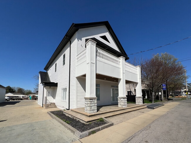
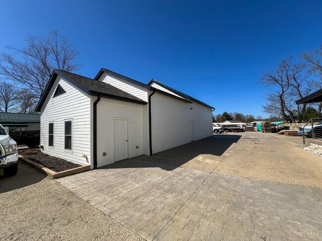
Property Record
8177 S State Route 48, Maineville, OH 45039

NEARBY LISTINGS FOR SALE OR LEASE
-
-
View all Maineville listings for sale on LoopNet.com
Property Detail
8177 S State Route 48
Cincinnati, OH-KY-IN
Maineville Corp
16-03-226-013
MAINEVILLE CORP. LOT 52-PT
Commercialnec
Warren
X
Ohio
39165C0228F
52
2024
0.06 AC
2024
Outlying Warren County
032203
Cincinnati/Dayton
3,308 SF
DEMOGRAPHICS near 8177 S State Route 48
1 Mile
3 Mile
5 Mile
2024 Total Population
6,234
33,628
90,830
2029 Population
6,826
36,777
97,636
Pop Growth 2024-2029
+ 9.50%
+ 9.36%
+ 7.49%
Average Age
40
40
40
2024 Total Households
2,258
12,328
34,359
HH Growth 2024-2029
+ 9.48%
+ 9.35%
+ 7.45%
Median Household Inc
$105,572
$107,466
$103,740
Avg Household Size
2.70
2.70
2.60
2024 Avg HH Vehicles
2.00
2.00
2.00
Median Home Value
$265,025
$277,290
$286,381
Median Year Built
2004
2000
1994
Nearby Places
Map Layers
Map Styles
 Street
 Aerial
- Restaurants
- Banks
- Shops
- Fitness
- Groceries
PUBLIC TRANSPORTATION
AIRPORT
Cincinnati/Northern Kentucky International
DRIVE
WALK
Distance
Cincinnati/Northern Kentucky International
59 min
37.6 mi
Nearby Properties
Address
Land Use
TOTAL SIZE
Lot Size
Zoning
Address
Land Use
TOTAL SIZE
Lot Size
Zoning
12,761 SF
47.72 AC
Address
Land Use
TOTAL SIZE
Lot Size
Zoning
21,601 SF
12.40 AC
Address
Land Use
TOTAL SIZE
Lot Size
Zoning
85,048 SF
15.95 AC
Address
Land Use
TOTAL SIZE
Lot Size
Zoning
Address
Land Use
TOTAL SIZE
Lot Size
Zoning
117,046 SF
20.33 AC
Address
Land Use
TOTAL SIZE
Lot Size
Zoning
23.89 AC
Address
Land Use
TOTAL SIZE
Lot Size
Zoning
16,289 SF
0.41 AC
Address
Land Use
TOTAL SIZE
Lot Size
Zoning
13,743 SF
0.29 AC
Address
Land Use
TOTAL SIZE
Lot Size
Zoning
58,761 SF
15.10 AC
Address
Land Use
TOTAL SIZE
Lot Size
Zoning
35,100 SF
10.92 AC
Address
Land Use
TOTAL SIZE
Lot Size
Zoning
12,571 SF
0.30 AC
Address
Land Use
TOTAL SIZE
Lot Size
Zoning
13,742 SF
4.70 AC
Address
Land Use
TOTAL SIZE
Lot Size
Zoning
65,906 SF
6.14 AC
Address
Land Use
TOTAL SIZE
Lot Size
Zoning
30,640 SF
5.10 AC
Address
Land Use
TOTAL SIZE
Lot Size
Zoning
0.41 AC
Address
Land Use
TOTAL SIZE
Lot Size
Zoning
4.52 AC
Address
Land Use
TOTAL SIZE
Lot Size
Zoning
14,505 SF
2.19 AC
Address
Land Use
TOTAL SIZE
Lot Size
Zoning
0.29 AC
Address
Land Use
TOTAL SIZE
Lot Size
Zoning
11,620 SF
2.03 AC
Address
Land Use
TOTAL SIZE
Lot Size
Zoning
26,232 SF
3.20 AC
Address
Land Use
TOTAL SIZE
Lot Size
Zoning
22,128 SF
4.52 AC
Address
Land Use
TOTAL SIZE
Lot Size
Zoning
0.30 AC
Address
Land Use
TOTAL SIZE
Lot Size
Zoning
81,187 SF
6.72 AC
Address
Land Use
TOTAL SIZE
Lot Size
Zoning
15.77 AC
Address
Land Use
TOTAL SIZE
Lot Size
Zoning
8,840 SF
24 AC
Address
Land Use
TOTAL SIZE
Lot Size
Zoning
8,631 SF
4.94 AC
Address
Land Use
TOTAL SIZE
Lot Size
Zoning
14,804 SF
131.33 AC
Address
Land Use
TOTAL SIZE
Lot Size
Zoning
20,080 SF
3.37 AC
Address
Land Use
TOTAL SIZE
Lot Size
Zoning
14,000 SF
1.89 AC
Address
Land Use
TOTAL SIZE
Lot Size
Zoning
5,111 SF
20.01 AC
The World's #1 Commercial Real Estate Marketplace
Connect with us
© 2025 CoStar Group
The information above has been obtained from sources believed reliable. While we do not doubt its accuracy we have not verified it and make no guarantee, warranty or representation about it. It is your responsibility to independently confirm its accuracy and completeness. Any projections, opinions, assumptions, or estimates used are for example only and do not represent the current or future performance of the property. The value of this transaction to you depends on tax and other factors which should be evaluated by your tax, financial, and legal advisors. You and your advisors should conduct a careful, independent investigation of the property to determine to your satisfaction the suitability of the property for your needs.