Property Record
818 8Th St, Midfield, AL 35228
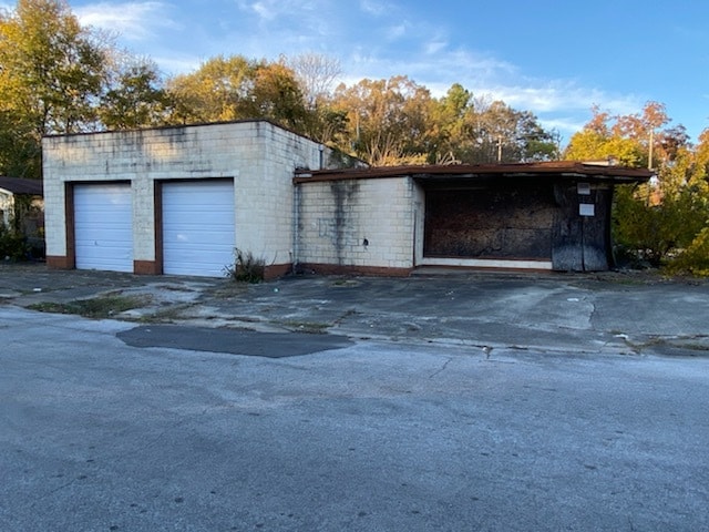


Property Detail
818 8Th St
30-00-22-4-017-014.000
LOTS 11 & 12 BLK 2 FAIRFIELD HGLDS 1ST ADD
Servicestation
JEFFERSON
B2
Alabama
B and X Area of moderate flood hazard, usually the area between the limits of the 100-year and 500-year floods.
11,12
2024
0.32 AC
2025
Bessemer
013400
Birmingham
1,263 SF
Birmingham, AL
NEARBY LISTINGS FOR SALE OR LEASE
-
-
View all Midfield listings for sale on LoopNet.com
DEMOGRAPHICS near 818 8Th St
1 mile
3 mile
5 mile
2025 Total Population
6,359
40,326
102,849
2030 Population
6,328
40,340
102,940
Pop Growth 2025-2030
(0.49%)
+ 0.03%
+ 0.09%
Average Age
41
41
41
2025 Total Households
2,533
15,930
42,029
HH Growth 2025-2030
(0.51%)
0.00%
+ 0.03%
Median Household Inc
$57,499
$49,034
$46,582
Avg Household Size
2.50
2.40
2.30
2025 Avg HH Vehicles
2.00
2.00
2.00
Median Home Value
$128,474
$125,466
$119,441
Median Year Built
1964
1964
1964
Nearby Places
Map Layers
Map Styles
 Street
 Aerial
Layers
 Traffic
 Biking
Places
Listings with unknown addresses are not visible on the map
- Restaurants
- Banks
- Shops
- Fitness
- Groceries
PUBLIC TRANSPORTATION
AIRPORT
Birmingham-Shuttlesworth International
Drive
Walk
Distance
Birmingham-Shuttlesworth International
21 min
15.8 mi
Freight Ports
Port of Mobile
Drive
Walk
Distance
Port of Mobile
285 min
242.6 mi
SALE & LEASE HISTORY
LISTING DATE
SALE/LEASE

Nov 16, 2021
For Sale
Nearby Properties
Address
Land Use
TOTAL SIZE
Lot Size
Zoning
Address
Land Use
TOTAL SIZE
Lot Size
Zoning
2,573,547 SF
112 AC
I2
Address
Land Use
TOTAL SIZE
Lot Size
Zoning
1,244,986 SF
I2
Address
Land Use
TOTAL SIZE
Lot Size
Zoning
200,650 SF
19 AC
R4
Address
Land Use
TOTAL SIZE
Lot Size
Zoning
195,495 SF
29 AC
B3
Address
Land Use
TOTAL SIZE
Lot Size
Zoning
553,137 SF
87 AC
I2
Address
Land Use
TOTAL SIZE
Lot Size
Zoning
460,483 SF
20 AC
I3
Address
Land Use
TOTAL SIZE
Lot Size
Zoning
145,300 SF
25 AC
R3
Address
Land Use
TOTAL SIZE
Lot Size
Zoning
191,664 SF
15 AC
R4
Address
Land Use
TOTAL SIZE
Lot Size
Zoning
288,000 SF
39.40 AC
I2-I
Address
Land Use
TOTAL SIZE
Lot Size
Zoning
219,210 SF
19 AC
M2
Address
Land Use
TOTAL SIZE
Lot Size
Zoning
230,088 SF
I3
Address
Land Use
TOTAL SIZE
Lot Size
Zoning
46,155 SF
1 AC
R4
Address
Land Use
TOTAL SIZE
Lot Size
Zoning
130,563 SF
I3
Address
Land Use
TOTAL SIZE
Lot Size
Zoning
218,210 SF
11 AC
CM-2
Address
Land Use
TOTAL SIZE
Lot Size
Zoning
77,902 SF
44 AC
I3
Address
Land Use
TOTAL SIZE
Lot Size
Zoning
58,822 SF
7.80 AC
B3
Address
Land Use
TOTAL SIZE
Lot Size
Zoning
69,344 SF
2 AC
B-1
Address
Land Use
TOTAL SIZE
Lot Size
Zoning
1,200 SF
14 AC
R3
Address
Land Use
TOTAL SIZE
Lot Size
Zoning
104,775 SF
9 AC
B-2
Address
Land Use
TOTAL SIZE
Lot Size
Zoning
157,183 SF
7 AC
B2
Address
Land Use
TOTAL SIZE
Lot Size
Zoning
1,437,077 SF
I2
Address
Land Use
TOTAL SIZE
Lot Size
Zoning
80,043 SF
11 AC
B3-C
Address
Land Use
TOTAL SIZE
Lot Size
Zoning
94,026 SF
5 AC
I2R2
Address
Land Use
TOTAL SIZE
Lot Size
Zoning
45,666 SF
3 AC
R5
Address
Land Use
TOTAL SIZE
Lot Size
Zoning
96,543 SF
9 AC
B2
Address
Land Use
TOTAL SIZE
Lot Size
Zoning
101,671 SF
15 AC
B2
Address
Land Use
TOTAL SIZE
Lot Size
Zoning
163,056 SF
I-3
Address
Land Use
TOTAL SIZE
Lot Size
Zoning
80,220 SF
7 AC
M2
Address
Land Use
TOTAL SIZE
Lot Size
Zoning
59,554 SF
1.37 AC
R2
Address
Land Use
TOTAL SIZE
Lot Size
Zoning
40,124 SF
0.88 AC
R4
The World's #1 Commercial Real Estate Marketplace
Connect with us
© 2026 CoStar Group
The information above has been obtained from sources believed reliable. While we do not doubt its accuracy we have not verified it and make no guarantee, warranty or representation about it. It is your responsibility to independently confirm its accuracy and completeness. Any projections, opinions, assumptions, or estimates used are for example only and do not represent the current or future performance of the property. The value of this transaction to you depends on tax and other factors which should be evaluated by your tax, financial, and legal advisors. You and your advisors should conduct a careful, independent investigation of the property to determine to your satisfaction the suitability of the property for your needs.