Property Record
818 A1a Beach Blvd, Saint Augustine, FL 32080
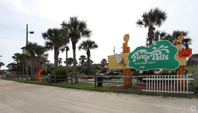

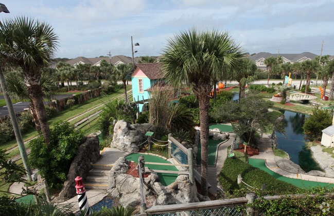
Property Detail
818 A1a Beach Blvd
172440-0000
6-1 PT OF LOT 4 -S170 OF N470 OF W373FT LYING E OF A1A (MINI GOLF) OR1849/1844
Amusementpark
ST. JOHNS
BU-1A
Florida
B and X Area of moderate flood hazard, usually the area between the limits of the 100-year and 500-year floods.
4
2025
1.75 AC
2026
St Johns County
021410
Jacksonville (Florida)
676 SF
Jacksonville, FL
NEARBY LISTINGS FOR SALE OR LEASE
DEMOGRAPHICS near 818 A1a Beach Blvd
1 mile
3 mile
5 mile
2025 Total Population
7,554
27,585
64,288
2030 Population
8,986
32,516
75,227
Pop Growth 2025-2030
+ 18.96%
+ 17.88%
+ 17.02%
Average Age
50
52
49
2025 Total Households
3,549
13,423
29,607
HH Growth 2025-2030
+ 19.36%
+ 18.38%
+ 17.58%
Median Household Inc
$79,605
$86,974
$78,790
Avg Household Size
2.10
2.00
2.10
2025 Avg HH Vehicles
2.00
2.00
2.00
Median Home Value
$736,206
$606,305
$490,150
Median Year Built
1991
1991
1993
Nearby Places
Map Layers
Map Styles
 Street
 Aerial
Layers
 Traffic
 Biking
Places
Listings with unknown addresses are not visible on the map
- Restaurants
- Banks
- Shops
- Fitness
- Groceries
Nearby Properties
Address
Land Use
TOTAL SIZE
Lot Size
Zoning
Address
Land Use
TOTAL SIZE
Lot Size
Zoning
279,494 SF
6.06 AC
Address
Land Use
TOTAL SIZE
Lot Size
Zoning
209,356 SF
12.88 AC
RG-O
Address
Land Use
TOTAL SIZE
Lot Size
Zoning
106,797 SF
10.80 AC
Address
Land Use
TOTAL SIZE
Lot Size
Zoning
127,090 SF
4.06 AC
R2
Address
Land Use
TOTAL SIZE
Lot Size
Zoning
7,133 SF
18.57 AC
RS3
Address
Land Use
TOTAL SIZE
Lot Size
Zoning
8,556 SF
20.32 AC
CHT
Address
Land Use
TOTAL SIZE
Lot Size
Zoning
7,021 SF
6.29 AC
OR
Address
Land Use
TOTAL SIZE
Lot Size
Zoning
73,318 SF
9.77 AC
RS3
Address
Land Use
TOTAL SIZE
Lot Size
Zoning
85,384 SF
5.42 AC
R2
Address
Land Use
TOTAL SIZE
Lot Size
Zoning
46,787 SF
3.04 AC
BU1A
Address
Land Use
TOTAL SIZE
Lot Size
Zoning
15,872 SF
124.49 AC
OR
Address
Land Use
TOTAL SIZE
Lot Size
Zoning
62,867 SF
48.30 AC
OR
Address
Land Use
TOTAL SIZE
Lot Size
Zoning
54,119 SF
2.03 AC
BU-1
Address
Land Use
TOTAL SIZE
Lot Size
Zoning
36.64 AC
RG-O
Address
Land Use
TOTAL SIZE
Lot Size
Zoning
76,239 SF
1.07 AC
CM1
Address
Land Use
TOTAL SIZE
Lot Size
Zoning
27,185 SF
206.55 AC
PUD
Address
Land Use
TOTAL SIZE
Lot Size
Zoning
52,011 SF
11.51 AC
CG-B
Address
Land Use
TOTAL SIZE
Lot Size
Zoning
8,997 SF
7.13 AC
PUD
Address
Land Use
TOTAL SIZE
Lot Size
Zoning
46,796 SF
1.36 AC
R2
Address
Land Use
TOTAL SIZE
Lot Size
Zoning
52,176 SF
7.86 AC
Address
Land Use
TOTAL SIZE
Lot Size
Zoning
26,624 SF
2.24 AC
PUD
Address
Land Use
TOTAL SIZE
Lot Size
Zoning
25,453 SF
322.02 AC
OR
Address
Land Use
TOTAL SIZE
Lot Size
Zoning
20,618 SF
1.24 AC
BU-1A
Address
Land Use
TOTAL SIZE
Lot Size
Zoning
96,200 SF
7.76 AC
RG-O
Address
Land Use
TOTAL SIZE
Lot Size
Zoning
2,700 SF
4.20 AC
CM1
Address
Land Use
TOTAL SIZE
Lot Size
Zoning
15,700 SF
1.13 AC
RG-O
Address
Land Use
TOTAL SIZE
Lot Size
Zoning
16,270 SF
1 AC
Address
Land Use
TOTAL SIZE
Lot Size
Zoning
5,088 SF
1.99 AC
Address
Land Use
TOTAL SIZE
Lot Size
Zoning
2,950 SF
7.34 AC
OR
Address
Land Use
TOTAL SIZE
Lot Size
Zoning
7,318 SF
18 AC
OR
The World's #1 Commercial Real Estate Marketplace
Connect with us
© 2026 CoStar Group
The information above has been obtained from sources believed reliable. While we do not doubt its accuracy we have not verified it and make no guarantee, warranty or representation about it. It is your responsibility to independently confirm its accuracy and completeness. Any projections, opinions, assumptions, or estimates used are for example only and do not represent the current or future performance of the property. The value of this transaction to you depends on tax and other factors which should be evaluated by your tax, financial, and legal advisors. You and your advisors should conduct a careful, independent investigation of the property to determine to your satisfaction the suitability of the property for your needs.