Property Record
818 Route 171, Woodstock, CT 06281
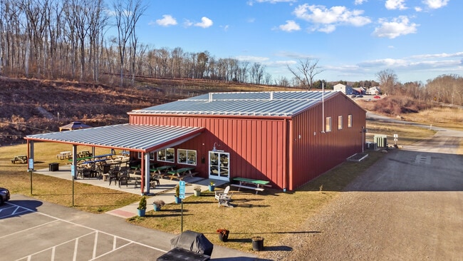
This Property Is For Sale
NEARBY LISTINGS FOR SALE OR LEASE
Property Detail
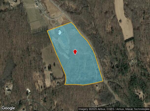
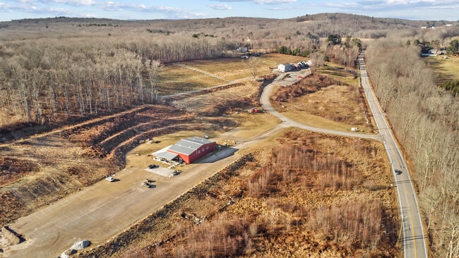
818 Route 171
Worcester, MA-CT
Windham
WOOD-005783-000047-000002A
Connecticut
Timberlandforesttreesagricultural
2a
2024
26.30 AC
2025
Windham County
901101
Hartford
4,264 SF
DEMOGRAPHICS near 818 Route 171
1 Mile
3 Mile
5 Mile
2024 Total Population
315
3,948
11,456
2029 Population
326
4,086
11,763
Pop Growth 2024-2029
+ 3.49%
+ 3.50%
+ 2.68%
Average Age
44
44
44
2024 Total Households
118
1,528
4,518
HH Growth 2024-2029
+ 4.24%
+ 3.53%
+ 2.79%
Median Household Inc
$97,023
$110,849
$99,982
Avg Household Size
2.60
2.50
2.40
2024 Avg HH Vehicles
2.00
2.00
2.00
Median Home Value
$456,249
$429,777
$409,710
Median Year Built
1974
1981
1980
Nearby Places
- Restaurants
- Banks
- Shops
- Fitness
- Groceries
PUBLIC TRANSPORTATION
AIRPORT
Worcester Regional
DRIVE
WALK
Distance
Worcester Regional
52 min
34.2 mi
Freight Ports
Port of Davisville, RI
DRIVE
WALK
Distance
Port of Davisville, RI
76 min
55.7 mi
Nearby Properties
Address
Land Use
TOTAL SIZE
Lot Size
Zoning
Address
Land Use
TOTAL SIZE
Lot Size
Zoning
119.01 AC
Address
Land Use
TOTAL SIZE
Lot Size
Zoning
55,340 SF
4 AC
0
Address
Land Use
TOTAL SIZE
Lot Size
Zoning
62,370 SF
46.40 AC
0
Address
Land Use
TOTAL SIZE
Lot Size
Zoning
16,771 SF
4.04 AC
0
Address
Land Use
TOTAL SIZE
Lot Size
Zoning
1.20 AC
0
Address
Land Use
TOTAL SIZE
Lot Size
Zoning
32,700 SF
2.61 AC
0
Address
Land Use
TOTAL SIZE
Lot Size
Zoning
43.90 AC
0
Address
Land Use
TOTAL SIZE
Lot Size
Zoning
17.90 AC
0
Address
Land Use
TOTAL SIZE
Lot Size
Zoning
7,450 SF
0.70 AC
0
Address
Land Use
TOTAL SIZE
Lot Size
Zoning
16,224 SF
6.30 AC
Address
Land Use
TOTAL SIZE
Lot Size
Zoning
3,000 SF
2.50 AC
0
Address
Land Use
TOTAL SIZE
Lot Size
Zoning
3,698 SF
93.55 AC
0
Address
Land Use
TOTAL SIZE
Lot Size
Zoning
6,602 SF
3.60 AC
0
Address
Land Use
TOTAL SIZE
Lot Size
Zoning
8.30 AC
0
Address
Land Use
TOTAL SIZE
Lot Size
Zoning
8,426 SF
8.31 AC
0
Address
Land Use
TOTAL SIZE
Lot Size
Zoning
335 AC
Address
Land Use
TOTAL SIZE
Lot Size
Zoning
4,752 SF
2.30 AC
0
Address
Land Use
TOTAL SIZE
Lot Size
Zoning
7,078 SF
2.90 AC
0
Address
Land Use
TOTAL SIZE
Lot Size
Zoning
22 AC
0
Address
Land Use
TOTAL SIZE
Lot Size
Zoning
Address
Land Use
TOTAL SIZE
Lot Size
Zoning
9,248 SF
2.10 AC
0
Address
Land Use
TOTAL SIZE
Lot Size
Zoning
29.58 AC
RR
Address
Land Use
TOTAL SIZE
Lot Size
Zoning
5,210 SF
25.06 AC
Address
Land Use
TOTAL SIZE
Lot Size
Zoning
3.20 AC
0
Address
Land Use
TOTAL SIZE
Lot Size
Zoning
544 SF
5.12 AC
Address
Land Use
TOTAL SIZE
Lot Size
Zoning
3.30 AC
0
Address
Land Use
TOTAL SIZE
Lot Size
Zoning
5,355 SF
1.25 AC
0
Address
Land Use
TOTAL SIZE
Lot Size
Zoning
Address
Land Use
TOTAL SIZE
Lot Size
Zoning
3,495 SF
0.81 AC
0
Address
Land Use
TOTAL SIZE
Lot Size
Zoning
1.70 AC
The World's #1 Commercial Real Estate Marketplace
Connect with us
© 2025 CoStar Group
The information above has been obtained from sources believed reliable. While we do not doubt its accuracy we have not verified it and make no guarantee, warranty or representation about it. It is your responsibility to independently confirm its accuracy and completeness. Any projections, opinions, assumptions, or estimates used are for example only and do not represent the current or future performance of the property. The value of this transaction to you depends on tax and other factors which should be evaluated by your tax, financial, and legal advisors. You and your advisors should conduct a careful, independent investigation of the property to determine to your satisfaction the suitability of the property for your needs.